Situation Summary
Solomon Islands maintains a stable security posture with no verified acute incidents or civil unrest in the past 24–48 hours. The country remains at baseline crime levels, with routine urban offences and isolated violent crimes treated as ordinary criminal matters. Two significant policy developments—a US maritime security agreement and expansion of nationwide unexploded-ordnance clearance—have generated political debate and increased security-sector operational tempo, but pose no immediate threat to population security or business continuity.
Key Developments
- Honiara, Guadalcanal – 29 July 2026 – Government formally signed US "Shiprider" maritime security agreement enabling joint patrols and interdictions in Solomon Islands' exclusive economic zone to combat illegal fishing, drug trafficking, and transnational maritime crime.
- Honiara, Guadalcanal – 29 July 2026 – Opposition Leader Manasseh Sogavare and other political figures publicly criticized the US maritime pact as a potential sovereignty compromise; debate remains peaceful and contained within parliamentary channels.
- Gold Ridge Mine area, Central Guadalcanal – 29 July 2026 – Authorities confirmed recovery of one body from the earlier Pit 1 ground collapse; ongoing site assessment and recovery operations continue with no new casualties or safety incidents reported in the past 24–48 hours.
- Honiara, Guadalcanal – 28–29 July 2026 – Prime Minister Matthew Wale and US officials announced an additional US$6 million in funding for nationwide unexploded-ordnance clearance, increasing technical survey and disposal activity in communities and former battle areas.
- Malaita Province – late July 2026 – Police handling isolated violent-crime cases (including a fatal stabbing in Auki with suspect arrested); no indication of broader communal violence or civil unrest beyond routine criminal investigation.
- National – late July 2026 – Risk-monitoring platforms and travel advisories report no credible threats to ports, airport, power infrastructure, or population centers; travel advice remains *exercise normal safety precautions*.
Highest-Risk Areas
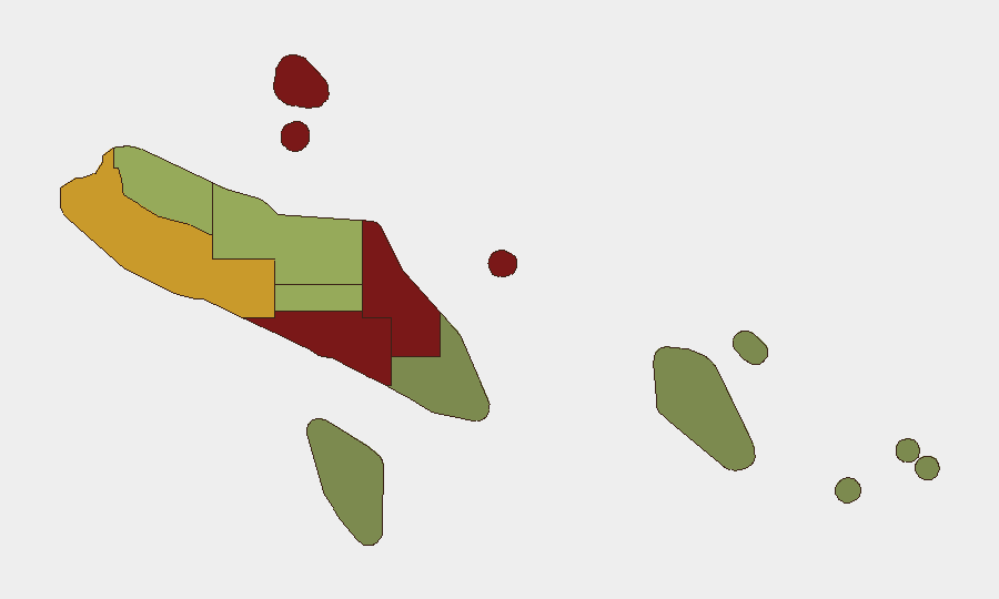
Honiara (risk 92) and Guadalcanal (risk 88) dominate the national risk profile, driven by population density, concentration of government and business assets, historical communal tensions, and elevated urban crime. Malaita (risk 85) remains a secondary concern owing to isolated serious crime and longstanding inter-provincial friction. Western, Choiseul, and Isabel provinces carry moderate risk (72, 58, 52 respectively), primarily reflecting lower population density, limited state presence, and baseline communal-dispute activity. Eastern provinces (Makira-Ulawa, Rennell and Bellona, Temotu) present minimal acute threat.
How GeoBit Would Assist
Security and risk teams should deploy AOI Monitoring & Early Warning on Honiara, Guadalcanal, and Malaita to detect onset of protests, communal clashes, or infrastructure disruption. OSINT fusion—combining X/Twitter sentiment analysis, news feeds, and radio SIGINT—enables continuous tracking of political stability and labor unrest linked to the maritime agreement or mining-sector disputes. Conflict & Military and Network & Actor Analysis capabilities support assessment of long-term regime stability and transnational crime networks that the new US maritime pact aims to address.
7-Day Outlook
Political debate over the US maritime agreement will likely persist in parliamentary and media channels but remains non-violent. UXO-clearance expansion will increase security-sector activity in affected communities, requiring coordination with local authorities; no escalation is anticipated. Overall security trajectory remains stable; routine crime monitoring and duty-of-care protocols for Honiara and Guadalcanal assets remain the priority.
Highest-Risk Areas — Ranked
| # | State / Region | Risk |
|---|---|---|
| 1 | Honiara | 92 |
| 2 | Guadalcanal | 88 |
| 3 | Malaita | 85 |
| 4 | Western | 72 |
| 5 | Choiseul | 58 |
| 6 | Isabel | 52 |
| 7 | Central Province | 48 |
| 8 | Makira-Ulawa | 38 |
| 9 | Rennell and Bellona | 22 |
| 10 | Temotu | 18 |
Sources
Previous Daily Briefs
A new Solomon Islands brief is written every day — each with its own risk map and downloadable CSV. Here's the last week; use the calendar to go further back.
📅 Browse every day by calendar →
Highlighted days have a brief. Tap a day for that day's map & analysis, or “csv” for that day's dataset ($5).
Atlas — our AI intelligence desk — emails them this snapshot personally. Nothing else, no list.