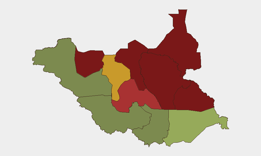
Situation Summary
South Sudan remains classified as a mid-tier global security risk (#48 globally, composite score 45) with no tracked security events recorded in the current 24–48-hour window (17–19 July 2026). The security environment is defined by persistent sub-national fragmentation: active armed clashes between SSPDF and opposition forces (particularly SPLA-IO) concentrated in the oil-rich northern states (Unity, Jonglei, Upper Nile) and ongoing government security operations in response to recent Independence Day attacks. No new major incidents have been confirmed since mid-July; however, the absence of current reporting does not indicate de-escalation, as communications infrastructure and media access remain severely constrained across conflict zones.
Key Developments
No discrete security or travel-risk incidents have been reliably verified and cross-confirmed for South Sudan within the last 24–48 hours (17–19 July 2026). Open-source reporting currently does not extend beyond mid-July.
Recent context (before 17 July, included for situational awareness):
- Akobo West County, Jonglei State (13–14 July): Fresh SSPDF–SPLA-IO clashes near Walgak; road-ambush risks documented for humanitarian and commercial traffic following the 5 July assassination of Akobo County Commissioner James Kueth Makuach.
- Warrap State (8–9 July and follow-up through 14 July): Coordinated armed attacks on government facilities during Independence Day observances resulted in at least 15 killed and 12 wounded; ongoing security crackdowns with checkpoints and aggressive screening through mid-July.
- Juba–Bor and Juba–Yei highway corridors (13–14 July): Intensified SSPDF and police presence, ad-hoc roadblocks, and aggressive vehicle screening increased checkpoint confrontation risks for travelers.
- Greater Upper Nile and Jonglei States (April–May 2026 escalation continuing): Sustained military operations including aerial bombardments; significant civilian casualties and displacement, particularly acute around Akobo County.
Highest-Risk Areas
Unity State (risk 95), Jonglei State (risk 93), and Upper Nile State (risk 88) dominate the threat landscape and account for the majority of active armed conflict, displacement, and infrastructure degradation. These three northern states are the epicenter of SSPDF–SPLA-IO competition for territorial control and oil-sector influence. Greater Pibor Administrative Area (risk 87) and Northern Bahr el Ghazal (risk 82) face secondary but significant pressures from communal violence, pastoral conflict, and localized armed groups. By contrast, Central Equatoria (risk 35) and Western Bahr el Ghazal (risk 28), which include or are adjacent to the capital Juba, carry materially lower risk profiles but remain subject to government security operations and checkpoint harassment.
How GeoBit Would Assist
Security and duty-of-care teams monitoring South Sudan should prioritize AOI (Area-of-Interest) Monitoring & Early Warning on Unity, Jonglei, and Upper Nile states to detect resumption of clashes or displacement events before mainstream reporting. Conflict & Military battle mapping and force-structure tracking provide real-time visibility of SSPDF and opposition movements that inform safe-passage routing. Routing & Network Analysis capabilities enable alternative-journey planning around active checkpoints and ambush-prone corridors, particularly on the Juba–Bor and Juba–Yei highways. Cross-reference with OSINT fusion and multi-language social-media monitoring to triangulate incident reports on X/Twitter, Telegram, and local radio before official confirmation.
7-Day Outlook
Absent new major-incident triggers, the security picture is likely to remain characterized by low-visibility localized clashes in the north, routine checkpoint operations in Central Equatoria, and humanitarian access constraints. However, heightened government security operations following the early-July Independence Day attacks suggest elevated checkpoint confrontation risk and potential for secondary security sweeps through at least late July. Monitoring of opposition communications and cross-border displacement patterns will be critical to early warning of broader escalation.
Highest-Risk Areas — Ranked
| # | State / Region | Risk |
|---|---|---|
| 1 | Unity | 95 |
| 2 | Jonglei | 93 |
| 3 | Upper Nile | 88 |
| 4 | Greater Pibor Administrative Area | 87 |
| 5 | Northern Bahr el Ghazal | 82 |
| 6 | Lakes | 78 |
| 7 | Warrap | 72 |
| 8 | Ruweng Administrative Area | 68 |
| 9 | Eastern Equatoria | 52 |
| 10 | Western Equatoria | 38 |
| 11 | Central Equatoria | 35 |
| 12 | Western Bahr el Ghazal State | 28 |
Previous Daily Briefs
A new South Sudan brief is written every day — each with its own risk map and downloadable CSV. Here's the last week; use the calendar to go further back.
📅 Browse every day by calendar →
Highlighted days have a brief. Tap a day for that day's map & analysis, or “csv” for that day's dataset ($5).
Atlas — our AI intelligence desk — emails them this snapshot personally. Nothing else, no list.