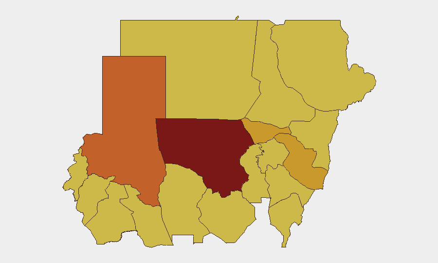
Situation Summary
Sudan remains in active civil war with no effective nationwide ceasefire in place as of 23 June 2026. The Rapid Support Forces (RSF) are executing a significant military offensive in North Kordofan State, particularly around El Obeid, while concurrent fighting continues in Khartoum and across Darfur. International actors including the UN Security Council have escalated warnings of imminent mass atrocities, reflecting the deteriorating humanitarian and security trajectory across most of the country.
Key Developments
- El Obeid, North Kordofan (21–22 June): RSF forces have tightened their encirclement of El Obeid with a major military build-up and intensified artillery shelling. UN Security Council issued a public warning of "imminent risk of mass atrocities," signaling alarm over the pace and scale of the offensive.
- Bara–El Obeid corridor, North Kordofan (21–22 June): Fluid front-line clashes between SAF and RSF reported, with SAF claiming recent seizures of strategic positions while RSF mounted counterattacks and briefly retook areas around Bara, indicating volatile and unstable control along key supply routes.
- Khartoum and surrounding districts (21–22 June): After a brief weekend truce lapsed, residents reported renewed artillery fire and clashes between SAF and RSF, with shelling audible across multiple neighborhoods and no effective ceasefire holding.
- Khartoum (22 June): Unconventional violence event recorded, consistent with reports of resumed active hostilities in the capital.
- Nile River State (21–22 June): Worsening economic and infrastructure stress in government-controlled areas, with residents facing long fuel queues, currency collapse, and rising food insecurity—heightening risk of localized unrest and criminality.
- South Sudan border / Jamjang reception area (21–22 June): UNHCR confirmed continued cross-border movement of Sudanese refugees into South Sudan, including new arrivals in June, reflecting ongoing displacement pressure from current fighting.
- UN and regional diplomacy (21–23 June): Multiple public statements and disapprovals from the UN toward Sudan, alongside public statements from South Sudan, underscore international diplomatic escalation and regional destabilization.
Highest-Risk Areas
North Kordofan State (risk score 100) is the single highest-risk area in Sudan, driven by the current RSF offensive and the imminent threat to El Obeid's civilian population. North Darfur, Al Khartum, and Al Qadarif follow closely (risk scores 71–75), with persistent active fighting, artillery shelling, and humanitarian deterioration. The remaining Darfur states, Blue Nile, River Nile, and Kassala all score 70 or above, indicating that risk is geographically widespread across Sudan's periphery and major urban centers, rather than isolated to a single theater.
How GeoBit Would Assist
Organizations with personnel or assets in Sudan should deploy AOI Monitoring & Early Warning on North Kordofan, Khartoum, and key transportation corridors to receive real-time alerts on fighting escalation and displacement patterns. Battle Mapping and Conflict Analysis combined with Routing & Network Analysis enable security teams to evaluate alternative supply routes and safe passage corridors around active clashes. OSINT Fusion drawing on social media, local reporting, and satellite imagery will maintain dynamic situational awareness on front-line movement, supply shortages, and humanitarian access windows—critical inputs for duty-of-care decisions on evacuation, shelter-in-place protocols, and resource positioning.
7-Day Outlook
The RSF offensive in North Kordofan is likely to intensify in the near term, with El Obeid facing the highest risk of further encirclement and assault within 5–7 days. Khartoum will remain under active pressure from renewed SAF–RSF clashes, with humanitarian conditions and fuel/food availability continuing to deteriorate. Expect continued diplomatic escalation at the UN and further cross-border refugee flows into South Sudan if fighting widens or intensifies.
Highest-Risk Areas — Ranked
| # | State / Region | Risk |
|---|---|---|
| 1 | North Kordofan State | 100 |
| 2 | North Darfur State | 75.2 |
| 3 | Al Khartum | 71.4 |
| 4 | Al Qadarif State | 71.4 |
| 5 | Central Darfur State | 70.9 |
| 6 | Blue Nile | 70 |
| 7 | River Nile State | 70 |
| 8 | Aj Jazira | 70 |
| 9 | Red Sea State | 70 |
| 10 | Kassala State | 70 |
| 11 | Sennar State | 70 |
| 12 | South Darfur State | 70 |
Sources
Previous Daily Briefs
A new Sudan brief is written every day — each with its own risk map and downloadable CSV. Here's the last week; use the calendar to go further back.
📅 Browse every day by calendar →
Highlighted days have a brief. Tap a day for that day's map & analysis, or “csv” for that day's dataset ($5).