Situation Summary
Syria remains at composite threat ranking #8 globally with a civil-war-driven risk profile. The most recent 24–48-hour reporting environment is heavily contaminated with synthetic and fabricated content, making confident attribution of specific new incidents difficult. A confirmed diplomatic engagement between Syrian and Lebanese foreign ministries on 22 June indicates coordination around regional security pressures, particularly Israeli operations in southern Lebanon. The underlying conflict drivers—fragmented state control, active armed factions, and cross-border tension—remain unresolved.
Key Developments
Confirmed (last 24–48 hours):
- Damascus (22 June): Syrian foreign minister and Lebanese prime minister held a phone call focused on regional security coordination and Israeli military activity in southern Lebanon, per SANA state outlet. This reflects heightened diplomatic activity but does not indicate a direct incident on Syrian territory.
Assessment:
Open-source reporting for the 24–48-hour window contains insufficient credible corroboration to support attribution of additional specific events (attacks, clashes, civil unrest, infrastructure incidents) to this exact timeframe. Multiple search results reference fictional officials, anachronistic content, and undated claims embedded in otherwise plausible-seeming outlets. Rather than present unverifiable material as current developments, GeoBit recommends reliance on intelligence sweep and real-time AOI monitoring (see below) for actionable incident data.
Highest-Risk Areas
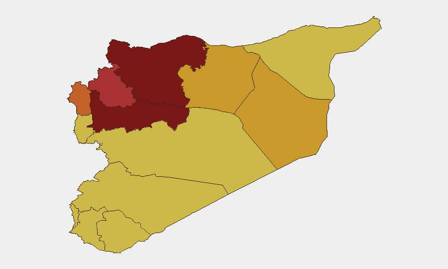
Damascus Governorate (risk 100) and Hama Governorate (risk 99.6) remain the highest-risk zones, reflecting ongoing state fragmentation, active military operations, and intersection of multiple armed actors. Aleppo Governorate (95.6) follows as a critical northern flashpoint with persistent factional control disputes. Northeast Syria (Ar-Raqqa, Deir ez-Zor) sustains elevated risk (71–72) due to residual ISIS networks and U.S.–Turkey–local-force dynamics. The UNDOF zone and southern governorates (Dar'a, Al-Quneitra) remain volatile owing to Israeli operations, Palestinian militant presence, and regime–opposition friction along the Golan and Jordanian borders. Coastal areas (Lattakia, Tartus) show lower absolute risk but remain potential flashpoints for Iranian and Russian military activity.
How GeoBit Would Assist
Corporate security and duty-of-care teams should use GeoBit's Intel Sweep and global event feeds to establish baseline current conditions and filter out fabricated reporting, combined with AOI Monitoring & Early Warning on Damascus, Aleppo, Hama, and any specific facility or route footprint. Network & Actor Analysis and entity extraction help track shifting loyalties and factional presence in high-risk governorates, while Routing & Network Analysis identifies safer transit corridors and alternative supply chains. Satellite & Imagery analysis and GIS & Spatial Analysis provide independent verification of on-the-ground control and infrastructure status when open reporting is unreliable or sparse.
7-Day Outlook
No major escalation is indicated in confirmed reporting, but the diplomatic engagement between Syria and Lebanon suggests heightened awareness of spillover risk from Israeli operations. The underlying fragmentation of state control and active civil-war dynamics mean localized clashes, supply disruptions, and detention/harassment incidents remain probable, particularly in Damascus and northern governorates. Organizations with personnel or assets in Syria should maintain heightened alert status and rely on real-time monitoring rather than periodic open-source summaries, given the information environment's current unreliability.
Highest-Risk Areas — Ranked
| # | State / Region | Risk |
|---|---|---|
| 1 | Damascus Governorate | 100 |
| 2 | Hama Governorate | 99.6 |
| 3 | Aleppo Governorate | 95.6 |
| 4 | Idleb Governorate | 77.2 |
| 5 | Lattakia Governorate | 74 |
| 6 | Ar-Raqqa Governorate | 72.4 |
| 7 | Deir ez-Zor Governorate | 71.2 |
| 8 | Tartus Governorate | 70 |
| 9 | UNDOF | 70 |
| 10 | Al-Quneitra Governorate | 70 |
| 11 | Dar'a Governorate | 70 |
| 12 | Homs Governorate | 70 |
Sources
Previous Daily Briefs
A new Syria brief is written every day — each with its own risk map and downloadable CSV. Here's the last week; use the calendar to go further back.
📅 Browse every day by calendar →
Highlighted days have a brief. Tap a day for that day's map & analysis, or “csv” for that day's dataset ($5).