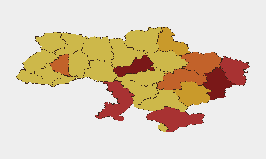
Situation Summary
Ukraine remains the highest-threat country globally (composite score 100) driven by active conventional warfare and sustained Russian strikes on civilian and military targets. Over the past 48 hours, Russia has escalated attacks on the capital and infrastructure, while Ukraine has executed coordinated deep-strike operations against Russian logistics, energy systems, and aviation assets across occupied territories. The intensity and geographic breadth of operations indicate sustained high-tempo conflict with no near-term de-escalation signals.
Key Developments
- Kyiv (Darnytskyi district), July 5, 2026 – Russia conducted a large-scale overnight missile and drone attack on the capital, triggering air raid sirens and widespread explosions. At least 13 killed and ~90 injured were reported, with fires affecting a vehicle service station and residential areas in Darnytskyi.
- Crimea (power infrastructure), July 4–5, 2026 – Ukrainian Unmanned Systems Forces reported striking 16 power stations across occupied Crimea in a 48-hour period, causing widespread blackouts and degrading Russian operational logistics on the peninsula.
- Hvardiiske airfield, occupied Crimea, July 4–5, 2026 – Ukraine's General Staff reported overnight strikes on the military airfield and adjacent ammunition depots, targeting Russian aviation and supply assets.
- Occupied Crimean military airbases, July 4–5, 2026 – Ukraine's Security Service reported drone strikes on two Russian military airbases, damaging or destroying at least seven combat aircraft in coordinated operations.
- Donetsk Oblast logistics, July 4–5, 2026 – Ukrainian forces struck two logistics bridges in occupied Donetsk during overnight operations, targeting Russian supply and troop movement corridors.
- Occupied Donetsk, Luhansk, and Kherson oblasts, July 4–5, 2026 – Ukraine's General Staff reported coordinated strikes on ammunition depots across these occupied regions as part of deep-penetration attack operations.
- Front-line combat (Donetsk region), July 4–5, 2026 – Ukraine's Defense Forces repelled 27 Russian attacks near Novokalynove and Avdiivka and 3 near Pervomaiske, indicating intense localized ground combat and high movement risk in these sectors.
- Dnipropetrovsk and Sumy regions, July 4, 2026 – Russian strikes killed 2 and injured over 20 across these regions, with partial destruction of high-rise residential buildings and ongoing rescue operations.
Highest-Risk Areas
Kyiv (risk 100) and Cherkasy Oblast (86.8) face the highest composite threat scores, driven by sustained Russian air and missile attacks on the capital and proximity to active ground operations. Eastern oblasts—Donetsk (80), Luhansk (79.2), and Kharkiv (75.4)—remain critical due to direct ground combat, logistics interdiction, and civilian exposure to artillery and drone strikes. Occupied or contested regions (Crimea, Zaporizhia, Kherson) present elevated risks from both Russian operations and Ukrainian strikes on military infrastructure, complicating movement and increasing collateral harm to civilians and commercial assets.
How GeoBit Would Assist
Teams managing personnel or assets in Ukraine should employ AOI Monitoring & Early Warning to track real-time threats in high-risk oblasts with automated alerting; Conflict & Military battle mapping to understand front-line positions and logistics corridors; and Routing & Network Analysis to identify safer transit routes avoiding active strike zones and ground combat areas. Satellite & Imagery analysis paired with OSINT fusion enables near-real-time correlation of reported strikes with damage assessment and humanitarian access routes.
7-Day Outlook
Sustained high-tempo missile and drone exchanges are expected to continue across Kyiv, Crimea, and rear-area Russian positions in occupied territory. Ground combat intensity in Donetsk and Luhansk oblasts will likely persist, with Ukrainian counter-logistics operations targeting Russian supply lines. No major operational changes are signaled; duty-of-care teams should assume elevated threat levels across all tracked regions for at least the next week.
Highest-Risk Areas — Ranked
| # | State / Region | Risk |
|---|---|---|
| 1 | Kyiv | 100 |
| 2 | Cherkasy Oblast | 86.8 |
| 3 | Donetsk Oblast | 80 |
| 4 | Luhansk Oblast | 79.2 |
| 5 | Autonomous Republic of Crimea | 77.4 |
| 6 | Odesa Oblast | 76.8 |
| 7 | Kharkiv Oblast | 75.4 |
| 8 | Ternopil Oblast | 73.7 |
| 9 | Dnipropetrovsk Oblast | 73.2 |
| 10 | Zaporizhia Oblast | 72.4 |
| 11 | Sumy Oblast | 71 |
| 12 | Kherson Oblast | 70.5 |
Sources
Previous Daily Briefs
A new Ukraine brief is written every day — each with its own risk map and downloadable CSV. Here's the last week; use the calendar to go further back.
📅 Browse every day by calendar →
Highlighted days have a brief. Tap a day for that day's map & analysis, or “csv” for that day's dataset ($5).
Atlas — our AI intelligence desk — emails them this snapshot personally. Nothing else, no list.