Situation Summary
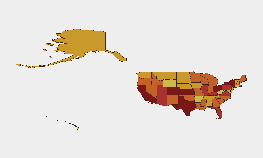
The United States remains GeoBit's highest-ranked threat environment globally (composite score 100, 6,047 tracked events), driven by elevated rates of gun violence, civil disorder, critical infrastructure strain, and cyber incidents concentrated in high-population and economically significant regions. Over the past 48 hours, major metropolitan areas have experienced a cluster of shootings, property crime, and infrastructure disruptions, with California, Kansas, New York, and Texas maintaining the highest composite risk scores. The threat landscape reflects persistent vulnerabilities in public safety, grid resilience, and digital security across multiple jurisdictions simultaneously.
Key Developments
- Miami, Florida (evening 29 June) – Targeted mass shooting in Little Havana killed 3 people and injured 7 others; suspect fled in dark SUV, remains at large.
- Chicago, Illinois (29 June night/early 30 June) – Series of drive-by shootings across South and West Sides resulted in 14 shot, 2 fatalities; multiple victims in critical condition, no arrests in principal attacks.
- Oakland, California (afternoon 29 June) – Illegal freeway sideshow on I-880 involved participants firing weapons; at least one vehicle struck by rounds; CHP dispersed crowd and is reviewing video for vehicle identification.
- Atlanta, Georgia (early 29 June) – Club-adjacent altercation in Buckhead escalated to gunfire, 1 dead and 3 injured; active homicide investigation ongoing.
- Portland, Oregon (evening 29 June) – Several hundred demonstrators protesting federal immigration enforcement blocked streets, broke business windows, and vandalized police vehicle near Justice Center and federal courthouse; officers declared unlawful assembly, deployed crowd-control munitions, 5 arrests made.
- New York City, New York (night 29 June) – Electrical signal fire near West 4th Street–Washington Square station caused partial service suspension on A/C/E and B/D/F/M lines; significant commuter disruption into morning rush period.
- Phoenix, Arizona (29 June) – Temperatures exceeding 115°F triggered record electricity demand and scattered outages in central and west Phoenix; emergency cooling centers activated, heat-illness risk elevated.
- New Orleans, Louisiana (29 June afternoon/evening) – Three armed carjackings in rapid succession across Mid-City and Gentilly neighborhoods; two suspects arrested following pursuit on I-610, others remain at large.
- Denver, Colorado (29 June) – Regional healthcare network ransomware incident forced patient diversions and system shutdown; emergency departments operational but elective procedures postponed.
Highest-Risk Areas
California (100), Kansas (90.4), New York (89.8), and Texas (86.3) drive the composite national risk score, reflecting large population concentrations, high rates of violent crime (particularly in major urban centers), active protest activity, and critical infrastructure interdependencies. Colorado, Ohio, and Florida follow closely, each experiencing cyber threats to essential services, gun violence, and heat-related infrastructure strain. These states' combined exposure to simultaneous violent crime, civil unrest, and infrastructure vulnerabilities creates compounding duty-of-care risks for organizations with distributed personnel and assets.
How GeoBit Would Assist
Security teams should deploy Intel Sweep and global event feeds with multi-language OSINT to establish real-time awareness of emerging incidents across high-risk states, combined with AOI Monitoring & Early Warning persistent watch on key metropolitan areas and critical infrastructure sites. Network & Actor Analysis would identify coordination patterns in the carjacking and shooting clusters, while GIS & Spatial Analysis and Routing & Network Analysis would enable alternative journey planning and facility access strategies to avoid incident zones and congested transit corridors.
7-Day Outlook
Gun violence and property crime are expected to remain elevated in California, Illinois, New York, and Texas through early July, with heat-related grid strain continuing in the Southwest. Federal law-enforcement investigations into the ransomware and firearms incidents may yield suspect identifications within 48–72 hours; escalation of immigration-related protest activity remains possible near federal facilities.
Highest-Risk Areas — Ranked
| # | State / Region | Risk |
|---|---|---|
| 1 | California | 100 |
| 2 | Kansas | 90.4 |
| 3 | New York | 89.8 |
| 4 | Texas | 86.3 |
| 5 | Colorado | 82.1 |
| 6 | Ohio | 81.2 |
| 7 | Florida | 79.4 |
| 8 | Illinois | 78.6 |
| 9 | Arizona | 78.1 |
| 10 | Pennsylvania | 78.1 |
| 11 | Utah | 77.8 |
| 12 | Kentucky | 77.7 |
Sources
Previous Daily Briefs
A new United States brief is written every day — each with its own risk map and downloadable CSV. Here's the last week; use the calendar to go further back.
📅 Browse every day by calendar →
Highlighted days have a brief. Tap a day for that day's map & analysis, or “csv” for that day's dataset ($5).