Situation Summary
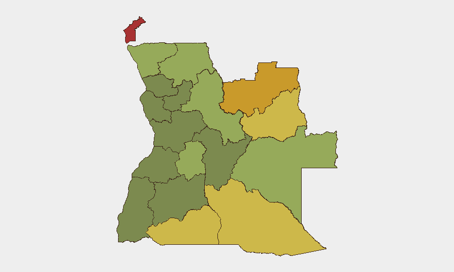
Angola remains a stable but fragmented risk environment, ranked #52 globally with a composite threat score of 37. No major security incidents, civil unrest, infrastructure disruptions, or travel alerts have been reported in the past 24–48 hours by credible international or regional sources. The primary risk concentration remains in the eastern and northeastern provinces, where resource competition, border permeability, and limited state presence drive elevated threat profiles.
Key Developments
No verified security or conflict incidents meeting recency and credibility thresholds were identified in Angola during the last 24–48 hours. Web research across mainstream news, African regional outlets, international security advisories, and social media monitoring yielded no reports of terrorism, armed conflict, civil unrest, crime events, infrastructure failures, or new travel warnings specific to Angola in this period.
Wildfire activity continues across multiple provinces and into neighboring DRC, with 12 documented wildfire events detected in recent reporting; however, these are environmental/seasonal incidents with indirect rather than direct security implications for most corporate operations. Wildfire zones include Cabinda, Lunda Norte, and border regions—areas already designated as highest-risk due to other drivers (resource conflict, criminal activity, governance gaps).
Corporate security teams should note that absence of 24–48 hour incident reporting does not indicate absence of underlying risk; it reflects a period without acute triggering events. The sub-national risk ranking and environmental signals (wildfire, porous borders) remain the primary planning factors.
Highest-Risk Areas
Cabinda Province (risk 78), Lunda Norte (72), and Lunda Sul (68) dominate the threat landscape. These three northeastern provinces are driven by overlapping factors: competition for diamond and mineral resources, limited state authority, cross-border trafficking networks, and historical separatist sentiment in Cabinda. Cuando Cubango, Cunene, and Moxico provinces (risk scores 64, 62, 58 respectively) form a secondary risk band along Angola's southern and eastern borders, where porous frontiers with Namibia, Botswana, and Zambia enable criminal movement and contraband flows. Central and southern provinces (Huambo, Bié, Huíla, Malanje) show markedly lower composite scores, reflecting greater state presence and economic stability.
Organizations with personnel or assets in extractive industries, logistics, or border-adjacent operations should prioritize risk mitigation in Cabinda and Lunda Norte; those in Luanda and southern hubs face routine urban crime and infrastructure concerns rather than political or armed-conflict risk.
How GeoBit Would Assist
Area-of-Interest (AOI) Monitoring & Early Warning would track Cabinda, Lunda Norte, and border crossing zones for emerging incidents (armed activity, protest mobilization, trafficking surges) with automated alerting. Intel Sweep and multi-language OSINT fusion would monitor regional news, local reporting, and cross-border intelligence signals to detect early indicators of instability before major events. Routing & Network Analysis would support duty-of-care teams in identifying and stress-testing safe transit corridors and alternative supply routes around high-risk provinces.
7-Day Outlook
No acute escalation indicators are visible in the immediate term. Seasonal wildfire activity will likely persist but remains a secondary operational concern. Risk trajectory is stable; near-term developments will be driven by routine criminal activity, resource-sector incidents, and any border-region trafficking or governance incidents rather than by political instability or conflict. Continuous monitoring of Cabinda and Lunda Norte provinces remains operationally warranted.
Highest-Risk Areas — Ranked
| # | State / Region | Risk |
|---|---|---|
| 1 | Cabinda Province | 78 |
| 2 | Lunda Norte Province | 72 |
| 3 | Lunda Sul Province | 68 |
| 4 | Cuando Cubango Province | 64 |
| 5 | Cunene Province | 62 |
| 6 | Moxico Province | 58 |
| 7 | Zaire Province | 54 |
| 8 | Huambo Province | 50 |
| 9 | Uíge Province | 48 |
| 10 | Malanje Province | 42 |
| 11 | Bié Province | 35 |
| 12 | Huíla Province | 32 |
Sources
Previous Daily Briefs
A new Angola brief is written every day — each with its own risk map and downloadable CSV. Here's the last week; use the calendar to go further back.
📅 Browse every day by calendar →
Highlighted days have a brief. Tap a day for that day's map & analysis, or “csv” for that day's dataset ($5).
Atlas — our AI intelligence desk — emails them this snapshot personally. Nothing else, no list.