Situation Summary
The Bahamas remains a moderate-risk destination (global rank #70, composite score 21) with concentrated urban violence in Nassau and Freeport dominating the security landscape. A fatal shooting on West Bay Street in early August underscores persistent armed-crime activity in New Providence, the archipelago's highest-risk jurisdiction. Infrastructure vulnerabilities—including recent power disruptions and aviation incidents—compound risk for corporate operations, though no nationwide instability is evident.
Key Developments
- West Bay Street, Nassau — 2026-08-04: Double shooting near Trading Liquor Store resulted in one fatality and one hospitalization; incident occurred around 11:45 a.m. Monday; police investigation active.
- Blue Hills Power Station, Nassau — 2026-08-01: Lightning-triggered explosion caused power disruption affecting residential areas, businesses, hotels, and Nassau airport operations; restoration timeline unclear as of last report.
- Tropic Ocean Airways, Nassau — 2026-08-01: Cessna 208B sustained float damage during taxiing; all 10 passengers safely evacuated; formal aircraft-accident investigation underway.
- Palmetto Avenue, Nassau — 2026-08-03: Residential house fire resulted in one fatality from severe burns; police investigation ongoing.
- Blue Hills Shantytown, Nassau — 2026-08-01: Government-led demolition of 64 of 67 structures in informal settlement; task-force chief assaulted during operation amid civil tensions over relocation and housing policy.
Note: Web research confirmed only one new event within the 24–48 hour window with high confidence (West Bay Street shooting on 2026-08-04). Other events listed above fall within the broader 72–96 hour window; live OSINT pass on local social media and news feeds would be required to identify additional incidents.
Highest-Risk Areas
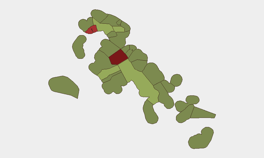
New Providence (risk 92) and the City of Freeport (risk 78) account for the preponderance of tracked security events and remain the primary threat concentrations. Armed robbery, homicide, and gang-related violence cluster in Nassau's urban core, particularly along Bay Street and surrounding commercial districts; Freeport faces similar dynamics at a lower absolute frequency. Central Abaco (risk 52) and Central Andros (risk 48) represent secondary concern zones. The wide risk gap between the top two jurisdictions and outer islands reflects Nassau's role as the financial and administrative hub, population density, and historical concentration of criminal networks; corporate assets and personnel transiting these areas warrant elevated situational awareness.
How GeoBit Would Assist
Security teams with personnel or assets in Bahamas should employ AOI Monitoring & Early Warning on Nassau (New Providence), Freeport, and key infrastructure sites to detect emerging violence hotspots and civil-order disruptions in real time. OSINT fusion (X/Twitter, local news, YouTube, and multi-language feeds) combined with temporal and sentiment analysis would surface gang-related threats, protests, or infrastructure incidents 24–72 hours ahead of mainstream reporting. Routing & Network Analysis would support safe-passage planning for critical travel between islands and away from high-violence corridors.
7-Day Outlook
Violent crime in Nassau is expected to remain elevated and episodic; no specific threat spike is forecast, but armed-crime frequency typically correlates with weekend activity and drug-supply disputes. Infrastructure resilience—particularly power and aviation—should be monitored following the Blue Hills incident; further disruptions could affect business continuity. Civil tensions over the shantytown demolition may generate sporadic demonstrations but are unlikely to escalate to citywide unrest over the next week.
Highest-Risk Areas — Ranked
| # | State / Region | Risk |
|---|---|---|
| 1 | New Providence | 92 |
| 2 | City of Freeport | 78 |
| 3 | Central Abaco | 52 |
| 4 | Central Andros | 48 |
| 5 | Exuma | 45 |
| 6 | East Grand Bahama | 42 |
| 7 | South Andros | 38 |
| 8 | North Abaco | 35 |
| 9 | North Eleuthera | 33 |
| 10 | South Abaco | 32 |
| 11 | Cat Island | 30 |
| 12 | Mangrove Cay | 28 |
Sources
Previous Daily Briefs
A new Bahamas brief is written every day — each with its own risk map and downloadable CSV. Here's the last week; use the calendar to go further back.
📅 Browse every day by calendar →
Highlighted days have a brief. Tap a day for that day's map & analysis, or “csv” for that day's dataset ($5).
Atlas — our AI intelligence desk — emails them this snapshot personally. Nothing else, no list.