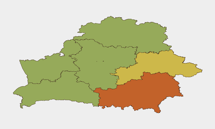
Situation Summary
Belarus remains a transit and logistics hub for irregular migration, cross-border weapons and goods flows, and unattributed drone activity linked to the broader Russia–Ukraine conflict. Risk is concentrated in border regions, particularly Homyel (Gomel), where infrastructure intersects with active smuggling routes and cross-border strike operations. National composite threat score remains moderate (8/136 globally), but subnational volatility—especially in Homyel Region (75)—reflects real friction along transit corridors and emerging state-facilitation of irregular border crossing. No major domestic security incidents have been recorded in the past 24–48 hours, but border infrastructure and regional stability continue to deteriorate.
Key Developments
- Zhlobin, Gomel Region, 2026-08-18 (~08:00): An unidentified drone crashed and detonated near the BMZ steel plant; Pramyslovaya Street was cordoned off. Drone type, origin, and target remain undisclosed. No casualties reported, but localized security response and industrial facility disruption occurred.
- Belarus–Russia border, Bryansk/Gomel, 2026-08-19: Ukrainian drones struck trucks carrying Iranian goods at the Krasny Kamen checkpoint terminal (Bryansk, Russia); at least one burning trailer continued into Gomel Region, Belarus. Civilian buses near the checkpoint were also reportedly hit. Risk of collateral impact on road traffic entering Belarus remains elevated.
- Novaya Guta, Belarus–Ukraine border, 2026-08-19: Russian and Ukrainian human rights commissioners conducted a 103-for-103 prisoner-of-war exchange on Belarusian soil. Reflects Belarus's continued role as a neutral exchange venue but signals sustained militarized activity and official Minsk presence along the conflict border.
- Belarus–EU road checkpoints, 2026-08-19–20: State Border Committee reported sharp vehicle queue buildup exiting Belarus toward EU member states, attributed to slow processing at neighboring (EU) checkpoints. Travel delays and extended processing times remain likely for the next 48–72 hours.
- Lazdijai District / Kapčiamiestis, Lithuania–Belarus border, 2026-08-19–20 (incident disclosure): Lithuanian government dismissed the head of border services for concealing a July 26 incident in which migrants attacked border guards and attempted to drag one into Belarusian territory. Investigation reveals tunnel construction likely supported by Belarusian special services. Signals institutional instability in neighboring Lithuanian border management and heightened scrutiny of Belarus-side facilitation.
Highest-Risk Areas
Homyel Region (75) dominates subnational risk due to proximity to the Russia–Ukraine conflict, the active Belarus–Russia border checkpoint infrastructure (now subject to Ukrainian drone strikes), and reported smuggling-tunnel networks. Minsk (68) reflects capital-city concentration of political tension, international diplomatic activity, and crime. Mahilyow (62), Brest (55), and Hrodna (52) follow as secondary migration and smuggling corridors. Risk is primarily transnational—irregular migration, cross-border drone spillover, and weapons trafficking—rather than domestic instability, but cumulative border pressure creates localized infrastructure and security-service strain.
How GeoBit Would Assist
Security teams should deploy AOI Monitoring & Early Warning on Homyel Region border checkpoints and industrial sites (e.g., Zhlobin, Krasny Kamen approaches) to detect drone activity, traffic disruption, and cross-border incidents in real time. Border & Disputed-Territory Search and OSINT Fusion (X/Twitter, Telegram channels, Ukrainian and Russian military-intelligence feeds) enable continuous tracking of migrant-tunnel networks, drone strikes, and checkpoint congestion. Routing & Network Analysis helps duty-of-care teams identify alternative road crossings and avoid queued checkpoints dynamically.
7-Day Outlook
Border congestion is expected to persist as EU-side processing backlogs clear slowly; checkpoint waits may exceed 12–24 hours for outbound traffic. Cross-border drone activity will likely continue in the Gomel Region as Ukrainian operations target Russian logistics in Bryansk; spillover risk remains low but non-zero for major roads and civilian infrastructure. Migrant-tunnel activity and state-facilitation investigations will keep Lithuania–Belarus border under heightened scrutiny, potentially triggering tighter controls and longer delays at EU entry points.
Highest-Risk Areas — Ranked
| # | State / Region | Risk |
|---|---|---|
| 1 | Homyel Region | 75 |
| 2 | Minsk | 68 |
| 3 | Mahilyow Region | 62 |
| 4 | Brest Region | 55 |
| 5 | Hrodna Region | 52 |
| 6 | Minsk Region | 48 |
| 7 | Vitsebsk Region | 45 |
Sources
Previous Daily Briefs
A new Belarus brief is written every day — each with its own risk map and downloadable CSV. Here's the last week; use the calendar to go further back.
- August 18, 2026
- August 15, 2026
- August 13, 2026
- August 11, 2026
- August 10, 2026
- August 8, 2026
- August 6, 2026
📅 Browse every day by calendar →
Highlighted days have a brief. Tap a day for that day's map & analysis, or “csv” for that day's dataset ($5).
Atlas — our AI intelligence desk — emails them this snapshot personally. Nothing else, no list.