Situation Summary
Benin remains a relatively stable West African state (global rank #50, composite threat score 30) but faces persistent terrorism and border-security pressures in its northern departments, where armed groups operate across porous frontiers with Burkina Faso and Niger. Criminal activity in urban centers, particularly greater Cotonou, continues under police management, with no major civil unrest or regime instability reported. The security picture reflects a state exercising functional law enforcement and military counter-terrorism operations, though northern border zones remain active theaters of conflict.
Key Developments
- No discrete, reliably documented incidents have been confirmed in Benin during the last 24–48 hours (since approximately 16 July 2026) across open-source security reporting, news wires, or social media monitoring. The absence of reportage likely reflects limited open-source coverage depth rather than absence of underlying activity.
- Koualou Border Zone (Benin–Burkina Faso frontier, northern Benin) – ongoing since 14 July 2026: Joint Beninese–Burkinabè counter-terrorism operation remains active; no new discrete clashes or attacks confirmed in the last 48 hours, but the operation itself continues as an active security theater.
- Godomey, Abomey-Calavi (Atlantique Department) – 15 July 2026 (outside 48h window but indicative of current trajectory): Republican Police conducted large anti-crime sweep targeting organized crime in two neighborhoods, arresting 52 suspects and seizing narcotics. Reflects intensified urban enforcement in greater Cotonou area.
- Government & Regional Diplomatic Activity – 16–17 July 2026: Multiple public statements and investigations involving Benin government, Nigerian authorities (Abuja), and Benin administration agencies occurred; specific substance not disclosed in available briefing materials, but signals active diplomatic or administrative engagement on unspecified matter(s).
Highest-Risk Areas
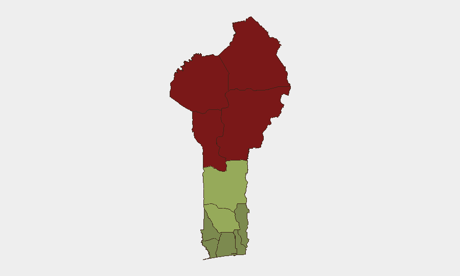
The four northernmost departments (Alibori, Atakora, Donga, Borgou) account for the vast majority of assessed threat concentration, with composite scores ranging from 92 down to 83. These zones sit astride the Benin–Burkina Faso and Benin–Niger borders, where armed groups exploit limited state presence and cross-border havens. The Zou Department (risk 45) represents a secondary risk tier; all southern coastal and central departments (Littoral, Ouémé, Atlantique) score below 35, though Atlantique sees urban-crime enforcement activity around Cotonu–Abomey-Calavi. Risk in the south is primarily criminal and urban; northern risk is predominantly terrorism and border-security related.
How GeoBit Would Assist
Teams with personnel or assets in Benin should prioritize AOI Monitoring & Early Warning on the Koualou sector and key northern border crossings to detect spikes in armed activity or displacement. Conflict & Military tracking (force structure, weapons capability, battle mapping) would provide operational detail on the evolving counter-terrorism campaign and armed-group capabilities. GIS & Spatial Analysis combined with Routing & Network Analysis enable security managers to plot safe corridors in the north and identify high-risk border zones for travel planning; Intel Sweep (OSINT, multi-language feeds, entity extraction) should maintain continuous watch on government statements, regional security bulletins, and social media sentiment to capture emerging incidents or diplomatic shifts outside the usual 24–48h reporting lag.
7-Day Outlook
No dramatic escalation or de-escalation is anticipated in the near term. The joint Benin–Burkina Faso border operation is likely to continue at current tempo, with sporadic clashes expected but no indication of major offensive by either side. Urban-crime enforcement in Cotonou and surrounding areas will persist under police management, and the diplomatic/administrative activity flagged on 16–17 July may yield policy or security posture adjustments within days.
Highest-Risk Areas — Ranked
| # | State / Region | Risk |
|---|---|---|
| 1 | Alibori Department | 92 |
| 2 | Atakora Department | 88 |
| 3 | Donga Department | 85 |
| 4 | Borgou Department | 83 |
| 5 | Zou Department | 45 |
| 6 | Collines Department | 42 |
| 7 | Plateau Department | 38 |
| 8 | Kouffo Department | 35 |
| 9 | Mono Department | 32 |
| 10 | Atlantique Department | 28 |
| 11 | Littoral | 25 |
| 12 | Ouémé Department | 22 |
Sources
Previous Daily Briefs
A new Benin brief is written every day — each with its own risk map and downloadable CSV. Here's the last week; use the calendar to go further back.
📅 Browse every day by calendar →
Highlighted days have a brief. Tap a day for that day's map & analysis, or “csv” for that day's dataset ($5).
Atlas — our AI intelligence desk — emails them this snapshot personally. Nothing else, no list.