Situation Summary
Botswana remains a low-threat operating environment globally (#157 in composite risk), with no confirmed security incidents or civil unrest in the current 24–48-hour window. The threat landscape is characterized by localized criminality and socioeconomic pressures concentrated in urban centers rather than systemic instability or political conflict. Current conditions support routine business and expatriate operations with standard precautions.
Key Developments
No discrete security, civil-unrest, crime, political-instability, or travel-risk incidents were independently verified in Botswana during the last 24–48 hours. Available reporting for 2026-08-03 to 2026-08-05 was insufficient to confirm time-stamped incidents meeting recency criteria.
*Background advisory (timeframe uncertain):* Botswana Police have issued warnings regarding missing citizens linked to fraudulent overseas job-offer schemes; this reflects a persistent threat vector rather than a fresh incident event.
Highest-Risk Areas
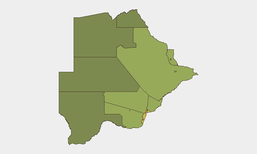
Gaborone (risk 72) and South-East District (68) carry the highest composite risk scores, followed by Lobatse (65) and Francistown (62). These urban and peri-urban centers concentrate Botswana's economic activity, population density, and associated property crime, vehicle theft, burglary, and organized petty crime. Mining towns (Jwaneng, Selebi Phikwe) also rank elevated due to cash-economy vulnerability and transient labor populations. Rural and northern districts (North-West, Central, North-East) remain substantially lower-risk, reflecting sparser populations and fewer high-value targets.
How GeoBit Would Assist
Security teams with personnel or assets in Gaborone, South-East District, or mining zones would benefit from Area-of-Interest (AOI) Monitoring & Early Warning configured on key facilities, border crossings, and transport corridors to detect emerging crime patterns or civil-unrest signals in real time. Intel Sweep and X/Twitter & Telegram OSINT capabilities enable continuous monitoring of local security advisories, police alerts, and community-reported incidents across a 24–48-hour cycle, improving detection of localized threats before they affect operations. Routing & Network Analysis can support alternative journey planning for staff movement in higher-risk urban areas during periods of elevated street crime.
7-Day Outlook
No escalation in national or regional security conditions is anticipated over the next seven days. Seasonal patterns and economic cycles remain the primary drivers of localized crime variance. Standard duty-of-care protocols (awareness of surroundings in urban centers, avoidance of cash display, secure transport, and liaison with local security partners) remain proportionate to the operating environment.
Highest-Risk Areas — Ranked
| # | State / Region | Risk |
|---|---|---|
| 1 | Gaborone | 72 |
| 2 | South-East District | 68 |
| 3 | Lobatse | 65 |
| 4 | Francistown | 62 |
| 5 | Jwaneng | 61 |
| 6 | Selebi Phikwe | 58 |
| 7 | Southern District | 55 |
| 8 | Kgatleng District | 50 |
| 9 | Kweneng District | 48 |
| 10 | North-East District | 45 |
| 11 | Central District | 42 |
| 12 | North-West District | 38 |
Sources
Previous Daily Briefs
A new Botswana brief is written every day — each with its own risk map and downloadable CSV. Here's the last week; use the calendar to go further back.
📅 Browse every day by calendar →
Highlighted days have a brief. Tap a day for that day's map & analysis, or “csv” for that day's dataset ($5).
Atlas — our AI intelligence desk — emails them this snapshot personally. Nothing else, no list.