Situation Summary
Burkina Faso remains classified as a high-threat environment (#25 globally) with a composite threat score of 93 across 17 tracked events. The country faces sustained pressure from terrorism, kidnapping risk, and border instability, compounded by an ongoing diplomatic rupture with France and the EU that has reduced institutional presence and consular services. Regional military tensions have intensified in the past 48 hours, with cross-border threat signals involving Ghana and Tunisia creating additional uncertainty. The overall trajectory suggests continued elevated risk with potential for rapid escalation in specific zones.
Key Developments
- 2026-07-20 · Ghana–Burkina Faso border: Threat event signal recorded; nature and specific location pending detailed field corroboration.
- 2026-07-19 · Burkina Faso (national): Public statement issued; context and messaging under analysis to assess policy or operational implications.
- 2026-07-19 · Burkina Faso vs. Tunisia: Conventional military force signal recorded; suggests potential cross-border military positioning or posturing that warrants monitoring.
- 2026-07-18 · Burkina Faso–Africa regional: Two threat signals detected on 18 July (Burkina Faso internal and cross-continental); indicators of escalating rhetoric or threat activity.
- Pre-brief context (15 July): EU diplomatic expulsion order (72-hour deadline) followed by French embassy/consulate closure; consular duty-of-care capacity significantly degraded.
Note: As of 16 July, no verified kinetic incidents (shootings, bombings, direct combat) were independently confirmed in the preceding 24–48-hour window. Current signals are threat-level and posturing events; ground-truth assessment ongoing.
Highest-Risk Areas
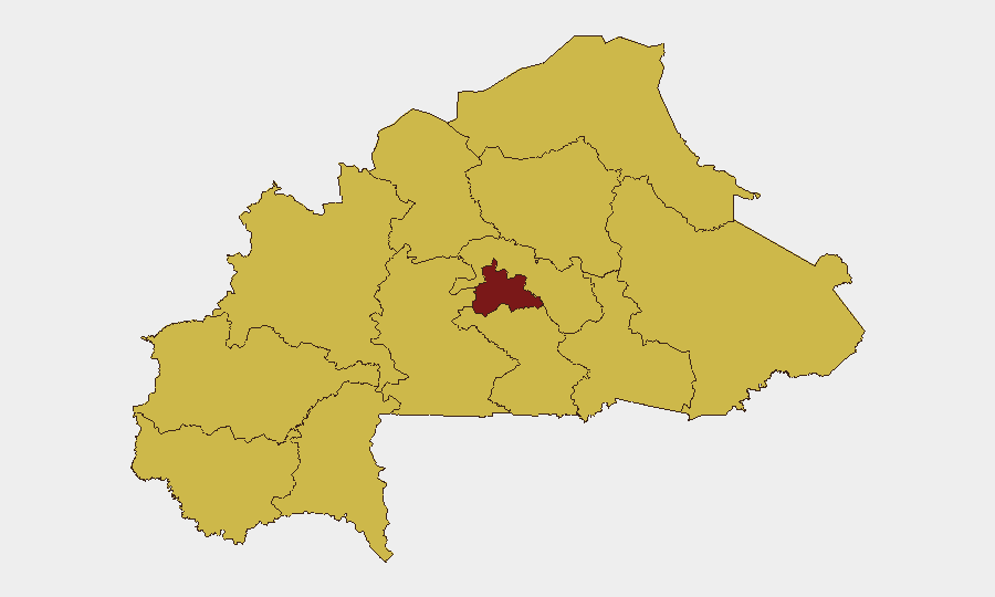
Centre region dominates the sub-national ranking at 95.2, substantially above all other zones (which cluster at 65.2). This elevation reflects concentration of insurgent activity, IED threat, kidnapping operations, and proximity to the capital and key infrastructure. The remaining ten tracked regions—spanning North, Sahel, East, Central-North, Southwest, Central-East, Central-South, Central-West, Boucle du Mouhoun, Upper-Basins, and Waterfalls—register uniform elevated risk, indicating nationwide insurgent presence and diffuse threat architecture rather than localized hotspots. Border zones (Burkina Faso–Ghana, Burkina Faso–Mali, Burkina Faso–Benin, Burkina Faso–Tunisia) are particular concern vectors given recent military signal activity.
How GeoBit Would Assist
Intel Sweep & OSINT Fusion: Continuous multi-language monitoring of X, Telegram, YouTube, and conflict feeds to confirm or downgrade the four threat events flagged 18–20 July and correlate with independent regional reporting. AOI Monitoring & Early Warning: Persistent geofencing of Centre region, border crossing points, and diplomatic compounds (Ouagadougou) with real-time alerting to duty-of-care teams if kinetic incidents, mass movement, or checkpoint changes occur. Conflict & Force-Structure Tracking: Battle mapping and force-positioning analysis to assess the military signal between Burkina Faso and Tunisia, clarify Ghana–Burkina Faso border tension, and triangulate intent. Routing & Network Analysis: Alternative journey planning and safe-passage corridor identification for personnel needing to relocate or conduct operations in high-risk zones, accounting for roadblocks and jihadist checkpoints.
7-Day Outlook
Regional military posturing is likely to persist and potentially intensify as diplomatic isolation deepens. Terrorist and kidnapping activity in Centre and northern regions should be expected to remain at or above current baseline. The absence of kinetic confirmation in the last 48 hours does not indicate de-escalation; rather, threat event signaling may precede tactical action by 24–72 hours. Organizations with personnel or assets in Burkina Faso should maintain heightened operational security posture and prepare contingency relocation protocols.
Highest-Risk Areas — Ranked
| # | State / Region | Risk |
|---|---|---|
| 1 | Centre | 95.2 |
| 2 | Upper-Basins | 65.2 |
| 3 | Boucle du Mouhoun | 65.2 |
| 4 | Central-West | 65.2 |
| 5 | Central-South | 65.2 |
| 6 | Central-East | 65.2 |
| 7 | Waterfalls | 65.2 |
| 8 | Southwest | 65.2 |
| 9 | Sahel | 65.2 |
| 10 | Central-North | 65.2 |
| 11 | East | 65.2 |
| 12 | North | 65.2 |
Sources
Previous Daily Briefs
A new Burkina Faso brief is written every day — each with its own risk map and downloadable CSV. Here's the last week; use the calendar to go further back.
📅 Browse every day by calendar →
Highlighted days have a brief. Tap a day for that day's map & analysis, or “csv” for that day's dataset ($5).
Atlas — our AI intelligence desk — emails them this snapshot personally. Nothing else, no list.