Situation Summary
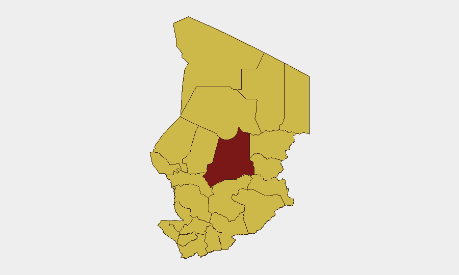
Chad remains a composite threat level #22 globally (score 90/100), with 16 tracked events in the current monitoring cycle. No verified security incidents inside Chad have been reported in the last 24–48 hours; however, kinetic activity directly across the Sudan–Chad border (Kulbus, West Darfur, 30 June) signals heightened cross-border instability. The security environment is characterized by persistent subnational fragmentation, with Batha region (risk 92.9) accounting for the majority of indexed threat exposure, while all other tracked regions cluster at moderate-to-elevated risk (62.9).
Key Developments
- Sudan–Chad Border | Kulbus, West Darfur | 30 June 2026: Sudanese army announced retaking of Kulbus, a strategic town immediately adjacent to the Chadian border. Competing claims by armed coalition ("Joint Forces") of full control remain unverified. This development directly affects cross-border security, displacement flows, and trafficking corridors into northern Chad.
- Diplomatic Statements | Multiple Capitals | 30 June–1 July 2026: Public statements by Chad, United States, Trinidad and Tobago, and Canadian authorities were logged in the event stream (1 July). Specific content not yet fully disambiguated in open reporting; recommend priority OSINT fusion review for any diplomatic incident or formal position shift affecting Chad operations.
- Coast Guard Property Seizure | Location TBD | 1 July 2026: A seizure/damage-of-property incident involving Chadian coast guard was recorded (1 July). Limited geographic and contextual detail available from current reporting; likely related to Lake Chad or border waterway interdiction. Recommend satellite & imagery analysis and maritime tracking capability deployment to assess extent and implications for supply/personnel movement.
No independently verified protests, armed clashes, criminal violence, or civil unrest inside Chad proper have been reported in the last 24–48 hours from cross-confirmed news wires or regional security feeds.
Highest-Risk Areas
Batha region (92.9) stands apart, driving nearly half of Chad's overall composite threat score and warranting primary focus for corporate security planning. The remaining 11 tracked regions—spanning the eastern, northern, and central zones (Ennedi-Ouest, Wadi Fira, Ouaddaï, Sila, Salamat, East Ennedi, Kanem, Lac, N'Djamena, Hadjer-Lamis, Chari-Baguirmi)—cluster at 62.9, indicating systemic, distributed vulnerability. The concentration of risk in border and remote zones reflects ongoing militia activity, trafficking, and displacement; elevated risk in N'Djamena itself signals potential for urban-center instability or governance friction despite capital status.
How GeoBit Would Assist
Corporate security teams should deploy AOI Monitoring & Early Warning on Batha and border zones (Sudan, Libya) for persistent watch with automated alerting; OSINT Fusion & Corroboration to disambiguate the recent diplomatic statements and clarify coast guard incident scope; and Satellite & Imagery Analysis plus Maritime Tracking to monitor Lake Chad and border crossing points for movement of personnel, goods, or military assets. Conflict & Military battle mapping and Border & Disputed-Territory Search will provide granular situational awareness as cross-border pressures evolve.
7-Day Outlook
The Sudanese border dynamics and unresolved coast guard action suggest moderate near-term escalation risk, particularly if cross-border armed groups test Chadian borders or if diplomatic friction translates into movement restrictions. Security teams should expect continued reporting ambiguity over the next 48–72 hours as events in Batha and border zones mature. Sustained monitoring of Sudan's control of Kulbus and any secondary armed-group repositioning is essential for forecasting impact on Chad's northern supply chains and personnel security.
Highest-Risk Areas — Ranked
| # | State / Region | Risk |
|---|---|---|
| 1 | Batha | 92.9 |
| 2 | Ennedi-Ouest | 62.9 |
| 3 | Wadi Fira | 62.9 |
| 4 | Ouaddaï | 62.9 |
| 5 | Sila | 62.9 |
| 6 | Salamat | 62.9 |
| 7 | East Ennedi | 62.9 |
| 8 | Kanem | 62.9 |
| 9 | Lac | 62.9 |
| 10 | N'Djamena | 62.9 |
| 11 | Hadjer-Lamis | 62.9 |
| 12 | Chari-Baguirmi | 62.9 |
Sources
Previous Daily Briefs
A new Chad brief is written every day — each with its own risk map and downloadable CSV. Here's the last week; use the calendar to go further back.
📅 Browse every day by calendar →
Highlighted days have a brief. Tap a day for that day's map & analysis, or “csv” for that day's dataset ($5).