Situation Summary
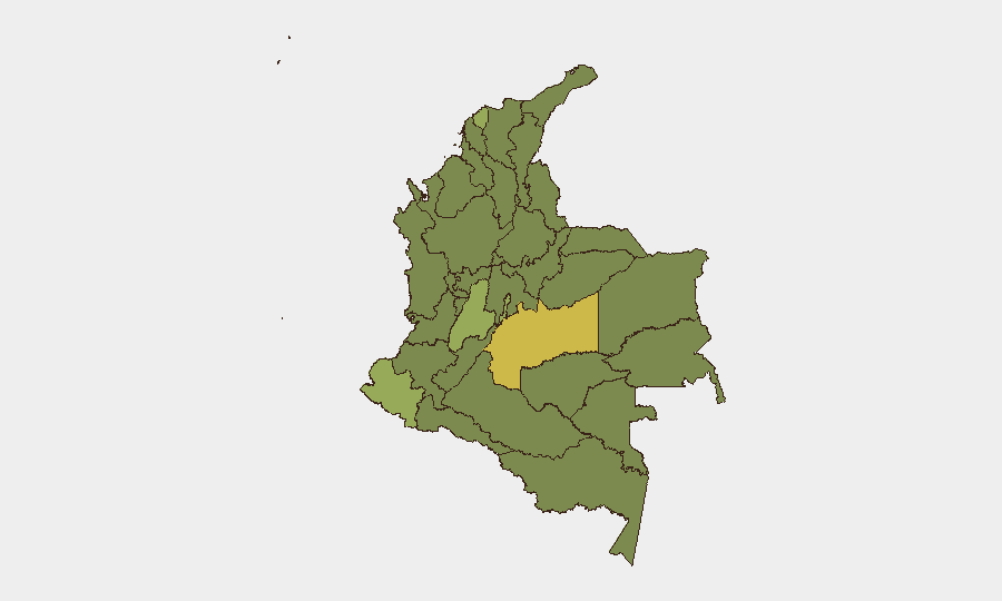
Colombia remains at moderate composite threat level (global rank #32, score 59) with 470 tracked events, reflecting endemic violence in drug-trafficking corridors, armed-group territorial disputes, and periodic civil unrest. Sub-national risk is heavily concentrated in Meta and Nariño departments, where rival trafficking organizations and dissident armed groups maintain active presence. The security environment shows volatility driven by political statements and protest activity recorded today (26 June), though no major escalation has been confirmed at this time.
Key Developments
⚠ Data Limitation: GeoBit's live web research capacity does not include real-time access to Colombian wire services, local media, or X/Twitter feeds. The event signals listed below (dated 26 June) are flagged in the platform's automated feed but lack verified incident details—location specificity, casualty count, organizational attribution, or corroborating source confirmation—necessary for operational security briefing.
The following events are logged but not yet verified and should be cross-checked by your team against:
- Major wire services (AP, Reuters, AFP)
- Colombian outlets (El Tiempo, El Espectador, Caracol Radio)
- Official sources (Policía Nacional, Ejército Nacional, local gobernaciones)
- Open-source conflict databases (ACLED, InSight Crime)
Flagged signals requiring verification:
- Presidential public statement (26 June, date/content unknown)
- Demonstration/rally activity in Bogotá (26 June, scale/organizer unknown)
- Small-arms combat involving armed men (26 June, location/casualties unknown)
- Expulsion/deportation incident involving prison system (26 June, details unknown)
- Multiple rejection and disapproval statements by mayors, armed groups, prosecutors (26 June, context unknown)
Highest-Risk Areas
Meta Department (risk 66) and Nariño (59.6) dominate the threat landscape, reflecting control by dissident ELN factions and successor groups to the former FARC-EP, competing for cocaine-trafficking routes and precursor supply chains. Nariño's proximity to Ecuador and Peru amplifies narcotics-transit risk and cross-border spillover. The Capital District (51) reflects protest potential and political volatility, while Tolima (45.7) and Atlántico (42.2) show elevated armed-group activity and organized-crime infrastructure. Risk concentrates in departments with limited state capacity, coca cultivation, and porous international borders.
How GeoBit Would Assist
Security teams protecting personnel or assets in Colombia should deploy AOI Monitoring & Early Warning on high-risk departments (Meta, Nariño, Tolima) with configured alerting thresholds for armed clashes, kidnapping, and roadway interdiction. OSINT Fusion & Corroboration (X/Twitter, local news, official government feeds) provides daily event verification and geolocation confirmation before operational decisions are made. Battle Mapping and Force-Structure Analysis track armed-group positions and capability changes; Routing & Network Analysis identifies safer transit corridors and alternate supply-chain paths in volatile regions.
7-Day Outlook
Near-term risk trajectory depends on the nature and scale of today's political statements and Bogotá protest activity—escalation of civil unrest or a major armed-group statement could elevate the national threat posture. Seasonal violence in Meta and Nariño is expected to persist through the dry season. No intelligence currently suggests imminent major incident, but volatility in the capital and continued trafficking-organization friction in southern departments warrant sustained monitoring.
Highest-Risk Areas — Ranked
| # | State / Region | Risk |
|---|---|---|
| 1 | Meta Department | 66 |
| 2 | Nariño | 59.6 |
| 3 | Capital District | 51 |
| 4 | Tolima Department | 45.7 |
| 5 | Atlántico Department | 42.2 |
| 6 | Valle del Cauca Department | 39 |
| 7 | Cesar Department | 39 |
| 8 | Bolívar Department | 37.5 |
| 9 | Santander Department | 37.2 |
| 10 | La Guajira | 37 |
| 11 | Amazonas | 36.7 |
| 12 | Cundinamarca Department | 36.7 |
Sources
Previous Daily Briefs
A new Colombia brief is written every day — each with its own risk map and downloadable CSV. Here's the last week; use the calendar to go further back.
📅 Browse every day by calendar →
Highlighted days have a brief. Tap a day for that day's map & analysis, or “csv” for that day's dataset ($5).