Situation Summary
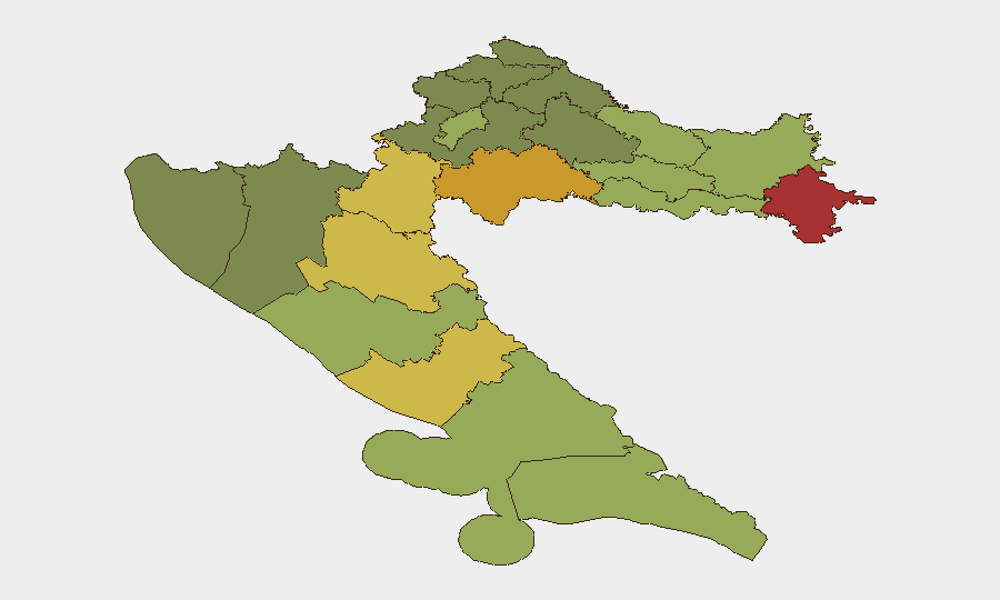
Croatia remains a low-to-moderate threat environment globally (#122, composite score 6) but faces elevated localised risks in its eastern border counties—Vukovar-Srijem, Sisak-Moslavina, and Karlovac—where historical conflict legacies, weapons proliferation, and cross-border crime persist. The last 48 hours have produced a mixed incident pattern: religious vandalism in Zagreb, several accidents (aircraft, bunker collapse, drowning), one weapons-trafficking arrest, and a targeted violent assault on Pag Island, with no indication of coordinated or systemic security deterioration. The overall trajectory remains stable, though eastern counties and religious sites warrant active monitoring.
Key Developments
- Zagreb, 24 July 0600h – Orthodox Church of the Transfiguration at Cvjetni trg vandalized overnight with religiously-motivated defacement; investigation ongoing and flagged as potential hate crime.
- Sava River near Zagreb, 23–24 July – Three Egyptian nationals drowned during informal river swimming; authorities attribute incident to dangerous currents and unregulated access points, indicating public-safety gap rather than security threat.
- Medulin, Istria, 24 July ~14:00h – Small aircraft crashed with four confirmed fatalities; classified as aviation accident, though relevant for travel-risk advisory in coastal Istria.
- Pula (Štinjan), 24 July 14:00h – Abandoned military bunker roof collapsed, injuring six foreign nationals; rescue operations completed without fatalities.
- Pag Island, 23 July – Young male stabbed and seriously injured; acquaintance arrested; classified as targeted rather than random violence.
- Đakovo (Osijek-Baranja County), 23 July – 53-year-old resident arrested following search uncovering large cache of firearms, grenades, and ammunition; charges filed for illegal weapons trafficking—significant indicator of arms proliferation in eastern region.
- Dramlje (Krapina-Zagorje), 23 July – 36-year-old German national arrested on three European arrest warrants for theft and fraud; extradition proceedings initiated.
- Istria County, 23 July – 66-year-old German national charged with child sexual exploitation; investigation concluded; victim-protection details withheld.
Highest-Risk Areas
Vukovar-Srijem, Sisak-Moslavina, and Karlovac counties dominate the risk ranking (scores 78, 72, 68 respectively) as residual legacies of the 1990s Homeland War: fragmented weapons caches, weak rule-of-law enforcement in rural pockets, and legacy smuggling networks remain embedded. The Đakovo arrest (23 July) exemplifies this—large-scale illegal armament discovery in Osijek-Baranja County (#8 in sub-national ranking) underscores persistent proliferation vulnerability. Coastal and urban zones (Zagreb #9, Split-Dalmatia #10) carry lower composite scores but remain relevant for transient populations, tourism security, and organised crime.
How GeoBit Would Assist
Security teams operating in or transiting Croatia should deploy AOI Monitoring & Early Warning on high-risk eastern counties (Vukovar-Srijem, Sisak-Moslavina) to flag weapons arrests, organised-crime activity, and cross-border incidents in real time. Intel Sweep and multi-language OSINT capabilities can monitor religious tensions and vandalism trends (as flagged by Zagreb church incident on 24 July) to anticipate escalation or copycat activity. Routing & Network Analysis supports safer alternative travel planning away from drowning-prone Sava access points and bunker-dense areas in Istria.
7-Day Outlook
No imminent destabilisation is anticipated; current incidents appear isolated rather than part of coordinated threat. Monitoring of religious-site security in Zagreb and weapons-trafficking enforcement in the east should remain elevated. Personnel and assets in Vukovar-Srijem, Sisak-Moslavina, and Karlovac counties should maintain baseline heightened awareness through 31 July pending further intelligence development.
Highest-Risk Areas — Ranked
| # | State / Region | Risk |
|---|---|---|
| 1 | Vukovar-Srijem County | 78 |
| 2 | Sisak-Moslavina County | 72 |
| 3 | Karlovac County | 68 |
| 4 | Lika-Senj County | 65 |
| 5 | Šibenik-Knin County | 62 |
| 6 | Brod-Posavina County | 58 |
| 7 | Zadar County | 55 |
| 8 | Osijek-Baranja County | 52 |
| 9 | City of Zagreb | 50 |
| 10 | Split-Dalmatia County | 48 |
| 11 | Požega-Slavonia County | 45 |
| 12 | Virovitica-Podravina County | 42 |
Sources
Previous Daily Briefs
A new Croatia brief is written every day — each with its own risk map and downloadable CSV. Here's the last week; use the calendar to go further back.
📅 Browse every day by calendar →
Highlighted days have a brief. Tap a day for that day's map & analysis, or “csv” for that day's dataset ($5).
Atlas — our AI intelligence desk — emails them this snapshot personally. Nothing else, no list.