Situation Summary
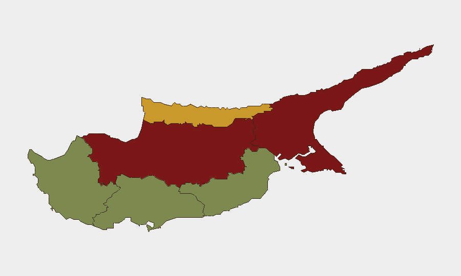
Cyprus maintains a low global threat ranking (composite score 4; #172 worldwide) with minimal tracked security events, yet sub-national disparities are pronounced. The divided island's northern regions—Nicosia, Famagusta, and Kyrenia—carry substantially elevated risk profiles (scores 72–92), while southern and western districts remain significantly lower-risk. Recent 24–48 hour activity reflects routine law enforcement operations and isolated incidents rather than systemic instability or organized threats.
Key Developments
- Nicosia, 2026-08-13 — Police conducted overnight operations resulting in 10 arrests, 295 traffic reports, and 108 speeding citations; enforcement also included drink-driving and criminal-activity checks across the capital.
- Orounta (Nicosia District), 2026-08-13 — A fire broke out in early morning hours and was contained with support from local firefighting units and the forestry department; no casualties or displacement reported.
- Kiti and Pervolia (Larnaca District), 2026-08-13 — Low-flying military aircraft reports prompted initial public concern; defence ministry later confirmed routine training flights by Greek F-16s and a French C-130 transport aircraft.
- Nationwide, 2026-08-12 — A 16-year-old was seriously injured in Aglantzia after a vehicle struck and dragged a personal mobility device; a separate stabbing incident in Limassol hospitalized a 44-year-old man.
- Nationwide, 2026-08-14 to 2026-08-16 — Cyprus Police announced enhanced patrols and checkpoint operations for the August 15 weekend, targeting dangerous driving, theft, and public-order violations in high-traffic leisure and travel areas.
Highest-Risk Areas
Nicosia (risk 92) and Famagusta (risk 88) dominate the sub-national threat landscape, reflecting the partition dynamics and longstanding communal sensitivities that characterize the island's northern sector. Kyrenia (risk 72) follows as a secondary concern. The southern and western regions—Limassol (22), Paphos (18), and Larnaca (28)—register substantially lower risk profiles and account for the majority of tourist and expatriate presence. Corporate security teams with personnel or operations in the north should maintain heightened situational awareness; those in the south face correspondingly reduced exposure to political, communal, or instability-related threats.
How GeoBit Would Assist
Security teams covering Cyprus would deploy AOI (Area-of-Interest) Monitoring & Early Warning on Nicosia and Famagusta to capture emerging tensions or incidents in real time, coupled with OSINT fusion and multi-language intelligence to track Turkish and Greek military activity, political signaling, and civil unrest indicators. GIS & Spatial Analysis and Routing & Network Analysis capabilities enable rapid identification of safe transit corridors and alternative routes around high-risk zones, while Risk & Threat Assessment profiles support duty-of-care and evacuation-readiness planning for personnel in the north. Integration of Intel Sweep feeds and sentiment analysis on local social media further provides early warning of localized flashpoints before escalation.
7-Day Outlook
Routine law enforcement and traffic operations are expected to continue, with heightened police presence sustained through the August 15 weekend holiday. No indicators of imminent systemic destabilization are evident, though the elevated baseline risk in northern regions warrants continued monitoring for any spike in communal or military signaling. Corporate asset exposure remains lowest in the south and west.
Highest-Risk Areas — Ranked
| # | State / Region | Risk |
|---|---|---|
| 1 | Nicosia | 92 |
| 2 | Famagusta | 88 |
| 3 | Kyrenia | 72 |
| 4 | Larnaca | 28 |
| 5 | Limassol | 22 |
| 6 | Paphos | 18 |
Sources
Previous Daily Briefs
A new Cyprus brief is written every day — each with its own risk map and downloadable CSV. Here's the last week; use the calendar to go further back.
- August 12, 2026
- August 10, 2026
- August 8, 2026
- August 6, 2026
- August 5, 2026
- August 4, 2026
- August 3, 2026
📅 Browse every day by calendar →
Highlighted days have a brief. Tap a day for that day's map & analysis, or “csv” for that day's dataset ($5).
Atlas — our AI intelligence desk — emails them this snapshot personally. Nothing else, no list.