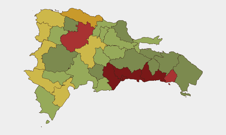
Situation Summary
The Dominican Republic maintains a composite threat score of 14 with no tracked active events as of 22 July 2026. The security environment remains characterized by endemic violent crime—armed robbery, assault, and theft—concentrated in urban centers and along the Haiti border, but no acute crisis or unrest is evident in current reporting. Seismic activity (two minor earthquakes near Punta Cana and Boca de Yuma in recent days) poses no immediate threat. The overall trajectory is stable, though chronic organized-crime and law-enforcement activity persist below crisis threshold.
Key Developments
Open-source reporting and social-media monitoring for the 24–48 hours preceding 22 July 2026 do not surface verifiable, incident-level security events meeting that recency standard. The most recent corroborated crime incidents and law-enforcement operations fall outside the immediate window:
- 16 July, Pedro Brand, Santo Domingo province: National Police arrested three alleged armed robbers linked to a criminal structure conducting armed assaults across multiple provinces. This operation followed intelligence work triggered by a remittance-company robbery in Moca.
- Mid-July, Cibao International Airport (Santiago) and San Pedro de Macorís: Authorities arrested three men on separate criminal warrants, including one detained attempting to board a flight to Philadelphia and two sought by U.S. justice.
Current advisory sources emphasize persistent risks (armed robbery, theft, violent crime in urban zones) rather than specific fresh incidents. Minor seismic events (M 3.4 and M 3.3) near Punta Cana and Boca de Yuma registered in recent days with no reported impacts.
Highest-Risk Areas
Santo Domingo (risk 92) and Nacional District (risk 88) dominate the sub-national ranking, reflecting concentrated violent crime, gang activity, and organized-crime operations in the capital and surrounding urban corridor. San Cristóbal, San Pedro de Macorís, and La Romana (risks 85, 83, 78) face elevated risk from armed robbery, trafficking, and criminal networks. Northern and southwestern border regions—Dajabón, Elías Piña, and Independencia Province (risks 68, 70, 64)—experience ongoing instability linked to migration, smuggling, and cross-border criminal activity with Haiti. These rankings reflect both incident density and underlying structural drivers (poverty, gang presence, limited police capacity in peripheral areas).
How GeoBit Would Assist
Intel Sweep and multi-language OSINT would monitor emerging gang and trafficking activity, social-media indicators of unrest, and law-enforcement operations across the sub-national hot zones. AOI Monitoring & Early Warning on Santo Domingo, Santiago, and border zones (Dajabón, Elías Piña) would flag incidents—arrests, violence, displacement—within 2–6 hours of occurrence, enabling rapid duty-of-care response for personnel and asset locations. Network & Actor Analysis would map criminal and trafficking networks linked to observed incidents, supporting threat modeling and travel-route risk assessment for corporate operations.
7-Day Outlook
No acute escalation is forecast for the week of 22–29 July. Violent crime is expected to remain endemic rather than epidemic, concentrated in known urban and border hotspots. Seismic activity may continue at minor magnitudes near the eastern Caribbean fault system, with negligible impact on corporate operations. Sustained monitoring of remittance robberies, gang enforcement, and border-zone smuggling remains operationally warranted for organizations with personnel or assets in the capital and northern provinces.
Highest-Risk Areas — Ranked
| # | State / Region | Risk |
|---|---|---|
| 1 | Santo Domingo | 92 |
| 2 | Nacional District | 88 |
| 3 | San Cristóbal | 85 |
| 4 | San Pedro de Macorís | 83 |
| 5 | La Romana | 78 |
| 6 | Santiago | 76 |
| 7 | Puerto Plata | 72 |
| 8 | Elías Piña | 70 |
| 9 | Dajabón | 68 |
| 10 | Barahona | 65 |
| 11 | Independencia Province | 64 |
| 12 | La Vega | 62 |
Sources
Previous Daily Briefs
A new Dominican Republic brief is written every day — each with its own risk map and downloadable CSV. Here's the last week; use the calendar to go further back.
📅 Browse every day by calendar →
Highlighted days have a brief. Tap a day for that day's map & analysis, or “csv” for that day's dataset ($5).
Atlas — our AI intelligence desk — emails them this snapshot personally. Nothing else, no list.