Situation Summary
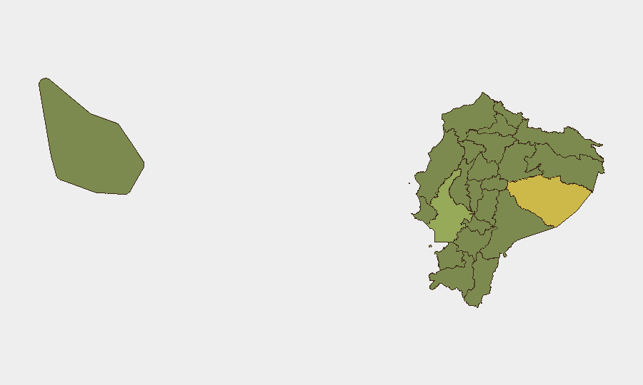
Ecuador remains at moderate global risk (rank 46, composite score 49) with 70 tracked threat events. The security environment is characterized by persistent criminality, localized military/police operations, and episodic civil unrest, particularly in frontier and coastal provinces. No major escalation has been reported in the last 24–48 hours, though the sub-national risk profile remains heavily concentrated in Pastaza (risk 64.4) and Guayas (47.3) provinces. The trajectory is one of endemic rather than acute instability.
Key Developments
Current reporting from the last 24–48 hours remains limited. Available event signals dated 2026-06-26 through 2026-06-28 indicate:
- Military operations and property seizure (2026-06-26, national scope): Armed forces conducted seizure/damage operations; specific location and operational scope require field corroboration.
- Administrative investigation (2026-06-26, national): Government administration initiated investigative action; details unavailable.
- Student and demonstrator activity (2026-06-26, likely Pichincha/Guayas): Student demands and arrest of demonstrators recorded; no immediate link to major civil unrest reported.
- Presidential demand (2026-06-26, national): Executive issued formal demand; subject and target unconfirmed.
- Publisher demand action (2026-06-28, likely Quito/Guayaquil media sector): Media outlet or publisher issued demand; context unclear.
- Diplomatic signal (2026-06-28, national): Ecuador signaled reduction in bilateral relations; counterparty and grievance require clarification.
Note: These event signals lack geographic specificity, operational detail, and independent cross-confirmation. Reliable Spanish-language outlets (El Universo, El Comercio, Primicias, Ecuavisa) and official channels (Policía Nacional, ECU911, municipal police X/Twitter) should be monitored for on-the-ground verification.
Highest-Risk Areas
Pastaza Province (64.4) represents the single highest-risk jurisdiction, likely driven by remote frontier geography, indigenous-settler tensions, environmental crime, and limited state presence. Guayas Province (47.3), which includes Guayaquil, reflects organized crime, port-related trafficking, gang violence, and urban security pressures endemic to Ecuador's largest economic and population center. Together, these two provinces account for the majority of national threat concentration. The remaining 10 provinces cluster in the 34–39 range, suggesting a secondary belt of concern across the Amazon border zone (Sucumbíos, Orellana), the northern frontier (Carchi, Imbabura), and coastal regions (Manabí, Santa Elena, Esmeraldas). Pichincha, though hosting the capital, ranks at 34.8—mid-range risk—suggesting that Quito's institutional presence provides moderate stabilization relative to periphery zones.
How GeoBit Would Assist
Security teams with personnel or assets in Ecuador should deploy persistent area-of-interest (AOI) monitoring and early-warning alerting on Pastaza, Guayas, and secondary-risk provinces, configured to flag criminality, civil unrest, and military/police operations within 24 hours. OSINT fusion across Spanish-language media, official police feeds, X/Twitter geosearch, and Telegram channels provides real-time event corroboration and actor identification. Route and network analysis enables rapid alternative-journey planning when road closures, curfews, or security cordons affect key corridors (e.g., Pan-American Highway, coastal routes). Multi-language sentiment and temporal analysis of social media can signal emerging protest cycles or cartel-related activity before mainstream reporting.
7-Day Outlook
Near-term trajectory remains stable at current endemic-threat baseline. Expect continued low-level police/military operations in Pastaza and Guayas, episodic student/civil-society demands in Quito and Guayaquil, and routine organized-crime activity in port and border zones. No indicators suggest major escalation, coup risk, or nationwide civil unrest in the next seven days, though frontier and coastal volatility may produce localized disruptions to transport and commerce.
Highest-Risk Areas — Ranked
| # | State / Region | Risk |
|---|---|---|
| 1 | Pastaza Province | 64.4 |
| 2 | Guayas Province | 47.3 |
| 3 | Manabí Province | 39.7 |
| 4 | Pichincha Province | 34.8 |
| 5 | Santa Elena Province | 34.8 |
| 6 | Sucumbíos Province | 34.4 |
| 7 | Orellana Province | 34.4 |
| 8 | Galápagos | 34.4 |
| 9 | Esmeraldas Province | 34.4 |
| 10 | Carchi Province | 34.4 |
| 11 | Imbabura Province | 34.4 |
| 12 | Santo Domingo de los Tsáchilas Province | 34.4 |
Sources
Previous Daily Briefs
A new Ecuador brief is written every day — each with its own risk map and downloadable CSV. Here's the last week; use the calendar to go further back.
📅 Browse every day by calendar →
Highlighted days have a brief. Tap a day for that day's map & analysis, or “csv” for that day's dataset ($5).