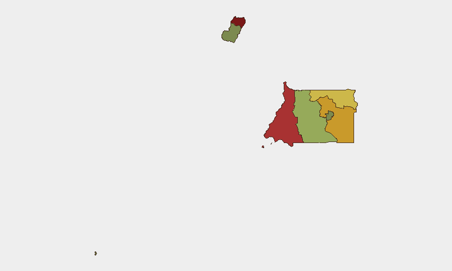
Situation Summary
Equatorial Guinea remains a low-frequency event environment; GeoBit has recorded zero tracked security incidents in the current reporting window and ranks the country #null globally (composite threat score 5). However, sub-national risk is highly concentrated: Bioko Norte (risk 85), Litoral Province (risk 78), and Wele-Nzas Province (risk 72) show materially elevated threat profiles, driven by ongoing crime and security-sector fragmentation. The country's land borders have remained closed since 15 December 2025, and security conditions in the major urban centers (Malabo, Bata) continue to deteriorate incrementally, with rising robbery, assault, and maritime piracy.
Key Developments
No discrete security, civil-unrest, crime, political-instability, infrastructure, or travel incidents were corroborated by GeoBit research in the last 24–48 hours. Web sources, local media feeds, and social-media monitoring did not surface dated recent events meeting the reporting threshold for this brief.
Note: The absence of tracked events does not indicate stability. General risk conditions—including robbery, assault, piracy in Malabo and Bata, and border closure since mid-December 2025—persist but are chronic rather than acute, and do not constitute new developments.
Highest-Risk Areas
Bioko Norte dominates the risk landscape (85), reflecting concentrated crime, security-force volatility, and urban instability in Malabo. Litoral Province (78) and Wele-Nzas Province (72) follow, with Litoral anchored by Bata's maritime piracy, robbery, and assault activity, and Wele-Nzas showing border-related and cross-border trafficking pressures. Centro Sur Province (45) and Bioko Sur (38) present moderate underlying risk. Djibloho (15) and Annobón Province (8) remain materially lower-risk zones. Corporate teams with operations or personnel in Bioko Norte, Litoral, or Wele-Nzas should maintain elevated duty-of-care posture; those in Malabo and Bata require active incident monitoring and contingency planning.
How GeoBit Would Assist
Security teams monitoring Equatorial Guinea should deploy AOI Monitoring & Early Warning on Malabo and Bata to detect incident escalation and maritime piracy upticks in real time. OSINT Fusion & Corroboration (X/Twitter, Telegram, local media) and Multi-Language Search will surface emerging crime, protest, or regime-stability signals ahead of mainstream reporting. Routing & Network Analysis supports alternative journey planning for personnel in high-risk provinces, and Maritime & Aviation Tracking provides situational awareness on port and airport disruptions tied to security incidents.
7-Day Outlook
No material change in the threat environment is anticipated over the next seven days absent a triggering event (e.g., border reopening, major crime incident, or regime action). Chronic conditions—piracy in Litoral waters, robbery in urban centers, and border closure—will likely persist. Continued passive monitoring and personnel awareness in Bioko Norte and Litoral is warranted.
Highest-Risk Areas — Ranked
| # | State / Region | Risk |
|---|---|---|
| 1 | Bioko Norte | 85 |
| 2 | Litoral Province | 78 |
| 3 | Wele-Nzas Province | 72 |
| 4 | Kié-Ntem Province | 68 |
| 5 | Centro Sur Province | 45 |
| 6 | Bioko Sur | 38 |
| 7 | Djibloho | 15 |
| 8 | Annobón Province | 8 |
Sources
Previous Daily Briefs
A new Equatorial Guinea brief is written every day — each with its own risk map and downloadable CSV. Here's the last week; use the calendar to go further back.
📅 Browse every day by calendar →
Highlighted days have a brief. Tap a day for that day's map & analysis, or “csv” for that day's dataset ($5).
Atlas — our AI intelligence desk — emails them this snapshot personally. Nothing else, no list.