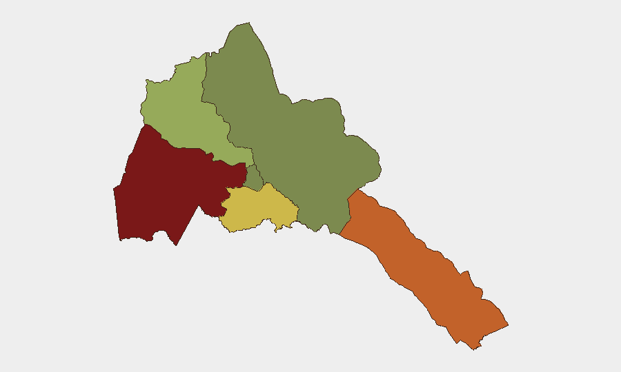
Situation Summary
Eritrea remains in a state of structural stability domestically, with no reported civil unrest, demonstrations, or major crime incidents in the last 24–48 hours. However, the country continues to face medium-to-high medium-term risk stemming from tensions with Ethiopia and potential involvement in any renewal of conflict in neighboring Tigray. Overall threat posture is unchanged; travel and operational security risk remains elevated due to regional dynamics rather than imminent domestic breakdown.
Key Developments
- Regional diplomatic posture (no new dated incident, 24–48h window): No specific security or political event has been reliably reported inside Eritrea on 1–2 August 2026. State media (ERi‑TV, Haddas Ertra) and Ministry of Information channels carry routine developmental content (medical outreach, administrative announcements) with no mention of clashes, arrests, or unrest in major population centers or border zones during this period.
- Ethiopia–Eritrea regional tension (ongoing context, not a new incident): Analytical reporting through February 2026 documents Ethiopian National Defense Force redeployments toward Tigray and notes Eritrean military presence in the border zone. This represents a sustained medium-term dynamic rather than a discrete incident in the last 48 hours.
- Gash-Barka region alert status (structural risk, not a new event): This western border region remains GeoBit's highest-risk sub-national area (composite score 92), driven by proximity to Sudan and historic militia activity. No fresh cross-border incursion or armed clash has been documented in the last 24 hours, but the region warrants persistent monitoring given Sudanese instability.
- Travel advisory status unchanged: Foreign governments (e.g., Australia, UK, others) maintain standing advisories recommending against or reconsidering travel to Eritrea due to potential conflict with neighboring states. These advisories predate the current 48-hour window and reflect longer-horizon risk assessment, not a new triggering event.
Highest-Risk Areas
Gash-Barka (risk 92) and the Southern Red Sea Region (risk 75) drive the country's composite threat score. Gash-Barka's exposure to Sudan's internal conflict and militia presence, combined with limited state capacity in remote areas, creates the highest discrete geographic risk. The Southern Red Sea Region's risk reflects both maritime security concerns and proximity to the disputed Hanish Islands and broader Red Sea geopolitical competition. Debub Region (risk 68) shows elevated risk linked to border proximity and militarization. By contrast, Maekel Region (capital Asmara; risk 18) and Northern Red Sea Region (risk 0) reflect tighter state control and lower incidence of armed activity, though corporate or expatriate operations in Asmara remain subject to broader Eritrean governance constraints (travel permits, movement restrictions).
How GeoBit Would Assist
Security teams with personnel or assets in Eritrea would deploy AOI Monitoring & Early Warning on Gash-Barka and Southern Red Sea Region to detect cross-border militia activity, Sudanese spillover, or military buildups with persistent alerting. Intel Sweep and multi-language OSINT fusion (ERi‑TV, regional press, Telegram channels, Tigray/Sudan-linked reporting) would provide 24-hour coverage of regime announcements, border incidents, and regional military moves. Conflict & Military force-structure tracking and border & disputed-territory search would maintain situational awareness of Eritrean and neighboring force dispositions affecting travel routes and security posture.
7-Day Outlook
Eritrea's near-term outlook remains stable domestically with low probability of sudden internal unrest or regime instability. Regional risk—particularly Ethiopia–Eritrea tensions and potential Tigray escalation—will likely persist at current levels unless new diplomatic moves or military incidents occur in the broader Horn. Operational security posture should remain alert to border-zone developments and travel advisory updates, but no imminent spike in threat is anticipated.
Highest-Risk Areas — Ranked
| # | State / Region | Risk |
|---|---|---|
| 1 | Gash-Barka | 92 |
| 2 | Southern Red Sea Region | 75 |
| 3 | Debub Region | 68 |
| 4 | Anseba | 55 |
| 5 | Maekel Region | 18 |
| 6 | Northen Red Sea Region | 0 |
Sources
Previous Daily Briefs
A new Eritrea brief is written every day — each with its own risk map and downloadable CSV. Here's the last week; use the calendar to go further back.
📅 Browse every day by calendar →
Highlighted days have a brief. Tap a day for that day's map & analysis, or “csv” for that day's dataset ($5).
Atlas — our AI intelligence desk — emails them this snapshot personally. Nothing else, no list.