Situation Summary
Fiji remains a relatively stable operating environment (global ranking #65, composite threat score 28) with no tracked major security crises as of 15 August 2026. Recent activity reflects endemic low-level street crime, drug enforcement, and isolated violent incidents rather than systemic instability. The Western Division continues to drive elevated national risk metrics, though incident frequency remains dispersed and localized.
Key Developments
- Lautoka, Vio Road — 10 Aug · Police conducted separate drug raids resulting in four arrests (two incidents); plastic packets of suspected methamphetamine and currency were seized. Enforcement activity suggests active narcotics distribution networks in the Western Division.
- Sigatoka — 9 Aug · A 38-year-old male died following an alleged assault; a father and son were arrested and charged with murder pending investigation and post-mortem examination. This represents a serious violent crime in the Central Division.
- Lautoka Remand Centre — 11 Aug · An Australian detainee was allegedly assaulted by a corrections officer; the officer was subsequently charged. Incident highlights potential duty-of-care exposure for foreign nationals in custody.
- Nadi International Airport — 14 Aug · Fiji Customs launched enhanced CCTV capability and a new multi-purpose security facility, strengthening border screening and detection at the primary international gateway.
- Western Division (Nadi–Lautoka corridor) — 10–28 Aug · The Republic of Fiji Military Forces announced Exercise Bougainville 2026, involving military movements, blank ammunition, and simulated battle sounds. No security threat; residents are advised not to mistake exercise activity for actual security incidents.
- Suva — 12 Aug · Police reported investigation into sexual harassment allegations involving officers within community policing Viber groups. Institutional integrity concern with reputational implications for law enforcement.
- Suva — 12 Aug · Police deployed enhanced security for Vodafone Super Deans Rugby semi-finals, indicating standard event-based protective measures and no specific credible threat to the event itself.
Highest-Risk Areas
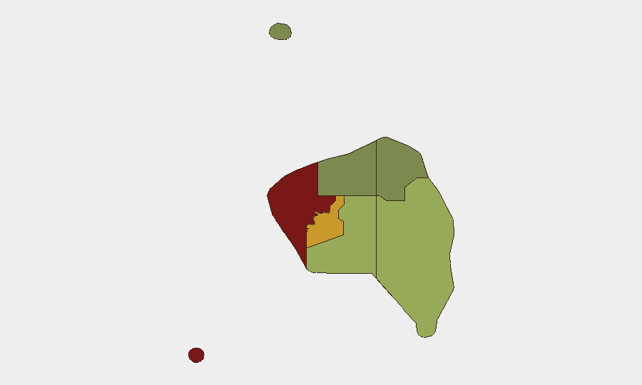
The Western Division (risk score 85) remains Fiji's highest-risk region, driven by concentrated drug-related arrests, property crime, and access via major transport routes (Lautoka, Nadi). The Central Division (risk score 72) has elevated risk due to recent fatal violence and broader interpersonal crime patterns. Together, these two divisions account for the majority of tracked incidents. Eastern, Northern, and Rotuma divisions show substantially lower activity and risk exposure. Risk concentration in the west reflects both genuine incident frequency and likely police enforcement emphasis in populated urban centers.
How GeoBit Would Assist
Security teams managing personnel or assets in Fiji should leverage AOI Monitoring & Early Warning on the Western and Central Divisions to track emerging crime hotspots, coupled with Intel Sweep and OSINT fusion to maintain real-time situational awareness of drug enforcement activity and violent incidents. Network & Actor Analysis would support identification of organized crime networks and key actors involved in narcotics distribution. Routing & Network Analysis can support secure movement planning to and from high-risk areas, particularly around Lautoka and Sigatoka.
7-Day Outlook
No major escalation is forecast. Routine crime, drug enforcement, and isolated violent incidents will likely continue at current baseline levels. The military exercise through 28 August presents no security risk to civilian operations but may generate routine noise and movement in the Nadi–Lautoka corridor; advance awareness limits operational friction.
Highest-Risk Areas — Ranked
| # | State / Region | Risk |
|---|---|---|
| 1 | Western | 85 |
| 2 | Central | 72 |
| 3 | Eastern | 45 |
| 4 | Northern | 38 |
| 5 | Rotuma | 12 |
Sources
Previous Daily Briefs
A new Fiji brief is written every day — each with its own risk map and downloadable CSV. Here's the last week; use the calendar to go further back.
- August 14, 2026
- August 13, 2026
- August 12, 2026
- August 11, 2026
- August 10, 2026
- August 9, 2026
- August 8, 2026
📅 Browse every day by calendar →
Highlighted days have a brief. Tap a day for that day's map & analysis, or “csv” for that day's dataset ($5).
Atlas — our AI intelligence desk — emails them this snapshot personally. Nothing else, no list.