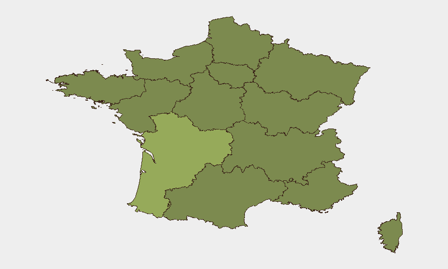
Situation Summary
France remains at composite threat rank #43 globally with sustained elevated terrorism alert status (Vigipirate Level 3 "urgence attentat") and 330 tracked security events. Active wildfire impacts in southern France near the Pyrenees are disrupting transport and major events, while heightened law-enforcement presence at transport hubs and public venues reflects sustained counter-terrorism posture. The threat environment is manageable but operationally disruptive; no acute mass-casualty incidents have been reported in the last 24–48 hours.
Key Developments
- Les Angles, Pyrénées-Orientales – 6 July 2026
Tour de France Stage 3 finale spectator ban enforced due to proximity of active wildfire (≈60 km away); organizers citing safety and operational constraints. *Impact: major public event disruption, crowd-control measures.*
- Pyrénées-Orientales wildfire zone – 5–7 July 2026
Approximately 1,821 hectares burned; ongoing fire-fighting operations and localized movement restrictions in rural southern France near Spanish border. *Impact: infrastructure vulnerability, potential air-quality degradation, road-closure risk.*
- Nationwide – ongoing as of 7 July 2026
Vigipirate Level 3 ("attack emergency") maintained; sustained visible security deployments and intensive screening at airports, train stations, and public venues. *Impact: traveler delays, heightened screening burden, operational planning constraints.*
- Major urban centers (Paris, Lyon, Marseille, Nice) – ongoing as of 6–7 July 2026
Authorities actively advising avoidance of demonstrations and large public gatherings; localized disruption risk when protests occur. *Impact: route planning uncertainty, public-transport bottlenecks during protest activity.*
- Tourist and transport hubs nationwide – ongoing as of 7 July 2026
Persistent petty crime advisory (pickpocketing, bag snatching) in high-footfall areas and on public transport; law-enforcement presence elevated but localized theft risk remains. *Impact: staff/traveler vulnerability, asset security during transit.*
Highest-Risk Areas
Nouvelle-Aquitaine (58.3) is the highest-risk region, driven by wildfire activity and proximity to the Spanish border. Île-de-France (39.5) ranks second, reflecting concentration of national infrastructure, major events, and transport hubs in and around Paris. Auvergne-Rhône-Alpes (35.0) and Brittany (33.8) follow, with Brittany showing notable risk elevation relative to historical patterns. The Pyrenees-Aquitaine corridor currently faces compounded environmental and mobility risk; metropolitan Paris-Ile-de-France remains the sustained terrorism-alert focal point due to symbolic and logistical criticality.
How GeoBit Would Assist
Security teams would deploy AOI Monitoring & Early Warning capabilities to track wildfire perimeter expansion, road closures, and air-quality degradation in southern France in real time. Routing & Network Analysis tools would enable dynamic alternative-route planning around Pyrenees wildfire zones and areas of demonstrated protest activity, protecting employee transit and supply chains. Intelligence & OSINT feeds (social-media sentiment, protest signaling, Telegram OSINT) combined with Early Warning & Prediction modules would provide 12–72 hour visibility into planned demonstrations and localized unrest, allowing duty-of-care teams to adjust movement and event attendance prior to disruption onset.
7-Day Outlook
Wildfire containment in southern France is expected to remain a dominant constraint on transport and event operations through 10–12 July; monitoring official prefectural updates is essential. Vigipirate Level 3 will likely persist through the immediate period; no material de-escalation of terrorism alert is signaled. Petty crime and protest-related disruption remain localized and event-driven, manageable through standard precaution protocols.
Highest-Risk Areas — Ranked
| # | State / Region | Risk |
|---|---|---|
| 1 | Nouvelle-Aquitaine | 58.3 |
| 2 | Ile-de-France | 39.5 |
| 3 | Auvergne-Rhône-Alpes | 35 |
| 4 | Brittany | 33.8 |
| 5 | Normandy | 30.5 |
| 6 | Occitania | 29.7 |
| 7 | Grand Est | 28.8 |
| 8 | Pays de la Loire | 28.8 |
| 9 | Bourgogne – Franche-Comté | 28.5 |
| 10 | Hauts-de-France | 28.3 |
| 11 | Centre-Val de Loire | 28.3 |
| 12 | Provence-Alpes-Côte d'Azur | 28.3 |
Sources
Previous Daily Briefs
A new France brief is written every day — each with its own risk map and downloadable CSV. Here's the last week; use the calendar to go further back.
📅 Browse every day by calendar →
Highlighted days have a brief. Tap a day for that day's map & analysis, or “csv” for that day's dataset ($5).
Atlas — our AI intelligence desk — emails them this snapshot personally. Nothing else, no list.