Situation Summary
Guinea-Bissau remains at composite threat level 8 globally (#131 ranking) with no acute security incidents tracked in the past 24–48 hours and no change to its Level 3 / Reconsider Travel advisory. The security environment is characterized by elevated but localized risk concentrated in the northern and eastern regions, driven by historical border instability, trafficking networks, and periodic civil-military tension rather than active armed conflict or nationwide destabilization. The current trajectory is stable with no indicators of imminent escalation.
Key Developments
- Nationwide, 10–13 Aug 2026 — No verified acute security incidents, armed conflict, major crime surges, or destabilization events reported in the last 24–48 hours.
- Nationwide, 10–13 Aug 2026 — Travel advisory status unchanged at Level 3 / Reconsider Travel; no new alert or escalation issued by risk authorities.
*Note: No discrete security events meeting the 24–48 hour window criterion have been identified. Monitoring remains active; background context on regional vulnerabilities is addressed below.*
Highest-Risk Areas
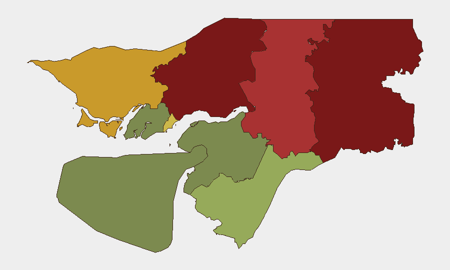
Northern and eastern Guinea-Bissau drive the country's composite risk profile. Gabu Region (risk 92) and Oio Region (risk 85) are the primary concern areas, followed by Bafatá (78) and Cacheu (72)—all bordering Senegal and Mali. These zones face chronic exposure to cross-border trafficking (drugs, arms, people), sporadic militia activity, and weak state capacity. Bissau Autonomous Sector (68), the capital region, carries elevated urban crime and political volatility risk. Southern regions (Tombali, Quinara, Biombo, Bolama) register substantially lower composite scores, reflecting relatively lower exposure to trafficking corridors and border spillover.
How GeoBit Would Assist
Security teams with personnel or assets in Guinea-Bissau should use GeoBit's AOI Monitoring & Early Warning to establish persistent watches on Gabu, Oio, and Bafatá regions and alert on changes in activity patterns, armed-group positioning, or checkpoint activity. Intelligence & OSINT capabilities—including multi-language social-media monitoring (X, Telegram), radio SIGINT, and sentiment analysis—enable early detection of political tension or civil unrest before formal incidents crystallize. For duty-of-care assessment and route planning, Routing & Network Analysis and Conflict & Military mapping support alternative journey planning and real-time positioning relative to highest-risk zones.
7-Day Outlook
No indicators suggest imminent escalation or acute incident onset over the next seven days. Routine low-level trafficking, administrative border tension, and petty crime remain baseline expectations in northern regions. Monitoring should focus on any shift in militia signaling, ECOWAS mediation developments (ongoing since early August), or political rhetoric that could signal renewed civil-military friction.
Report Date: 2026-08-13
Confidence: Moderate (stable baseline; absence of reports does not preclude localized incidents in remote areas)
Next Briefing: Daily update; escalation alert if Level 3+ event triggered
Highest-Risk Areas — Ranked
| # | State / Region | Risk |
|---|---|---|
| 1 | Gabu Region | 92 |
| 2 | Oio Region | 85 |
| 3 | Bafatá Region | 78 |
| 4 | Cacheu Region | 72 |
| 5 | Bissau Autonomous Sector | 68 |
| 6 | Tombali Region | 45 |
| 7 | Quinara Region | 38 |
| 8 | Biombo Region | 32 |
| 9 | Bolama Region | 15 |
Sources
Previous Daily Briefs
A new Guinea-Bissau brief is written every day — each with its own risk map and downloadable CSV. Here's the last week; use the calendar to go further back.
- August 11, 2026
- August 10, 2026
- August 8, 2026
- August 6, 2026
- August 5, 2026
- August 4, 2026
- August 3, 2026
📅 Browse every day by calendar →
Highlighted days have a brief. Tap a day for that day's map & analysis, or “csv” for that day's dataset ($5).
Atlas — our AI intelligence desk — emails them this snapshot personally. Nothing else, no list.