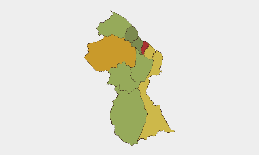
Situation Summary
Guyana remains a stable, low-threat environment globally (ranked #126 with a composite score of 14), but sub-national risk concentration in the coastal regions—particularly Demerara-Mahaica and Cuyuni-Mazaruni—reflects localized challenges in narcotics enforcement, road safety, and child welfare. The past week saw routine drug interdictions, a fatal traffic collision, and a high-profile presidential flight disruption, none of which signal systemic security deterioration. Overall trajectory remains steady with isolated operational incidents typical of a developing Caribbean nation with active law-enforcement and maritime activity.
Key Developments
- October 21, Upper Berbice River (Wiruni and Sandhills): Police destroyed seven cannabis plantations (28 acres) and 440 pounds of dried product; no arrests documented. Reflects ongoing narcotics enforcement in remote interior regions.
- October 22, East Bank Demerara: An 8,000-barrel waste-oil barge listed at a private wharf triggered multi-agency environmental contamination response; officials reported stabilization with cargo intact. Indicates maritime and industrial oversight activity.
- October 23, Long Creek, Soesdyke-Linden Highway: Passenger car struck a Guyana Defence Force truck at approximately 8:45 p.m., resulting in four fatalities and three injuries; police attributed cause to speeding. Represents elevated road safety risk on key transport corridors.
- October 24, Guyana–United States Air Route: An American Airlines flight carrying President Irfaan Ali returned to Miami following a passenger-crew dispute, disrupting scheduled international service. No security threat to the president was reported.
- October 25, Nationwide: President Ali announced task force and action plan addressing child safety after at least three child homicides within a three-week span. Signals government response to emerging public-safety concern.
- October 25, Corentyne (Whim and No. 51 Village, Berbice): A 36-year-old laborer was charged with 10 offenses following an alleged confrontation with police during traffic enforcement on October 20; court remand occurred during the reporting week.
Highest-Risk Areas
Demerara-Mahaica (risk 78) and Cuyuni-Mazaruni (risk 72) dominate the sub-national ranking, reflecting concentrated urban and trafficking-corridor vulnerabilities in the capital region and interior drug-production zones. East Berbice-Corentyne and Mahaica-Berbice (risks 62 and 65, respectively) show elevated exposure linked to border permeability, maritime transit, and smaller-scale narcotics activity. The interior and southern regions (Potaro-Siparuni through Essequibo Islands, risks 48–35) carry lower but persistent risk associated with remote geography and limited law-enforcement presence. Road safety, child welfare, and routine narcotics enforcement appear to be the primary drivers across coastal and near-interior areas.
How GeoBit Would Assist
Security teams operating in Guyana would benefit from AOI Monitoring & Early Warning to track trafficking corridors and high-risk zones in Demerara-Mahaica and Cuyuni-Mazaruni in real time, paired with OSINT Fusion & Corroboration to validate incident reports and distinguish routine law-enforcement activity from emerging threats. Risk & Threat Assessment capabilities would enable duty-of-care teams to model exposure along key transport routes (e.g., Soesdyke-Linden Highway) and maritime zones, while GIS & Spatial Analysis supports asset positioning and route planning to avoid identified hazard concentrations.
7-Day Outlook
No significant escalation or systemic deterioration is anticipated. Routine narcotics enforcement, road-safety incidents, and administrative responses to child welfare concerns will likely continue without substantial change to the overall security baseline. Monitoring of interior drug operations and coastal environmental incidents should remain part of standard duty-of-care protocols for operations in Demerara-Mahaica and Cuyuni-Mazaruni.
Highest-Risk Areas — Ranked
| # | State / Region | Risk |
|---|---|---|
| 1 | Demerara-Mahaica | 78 |
| 2 | Cuyuni-Mazaruni | 72 |
| 3 | Mahaica-Berbice | 65 |
| 4 | East Berbice-Corentyne | 62 |
| 5 | Upper Demerara-Berbice | 58 |
| 6 | Potaro-Siparuni | 48 |
| 7 | Barima-Waini | 45 |
| 8 | Upper Takutu-Upper Essequibo | 42 |
| 9 | Pomeroon-Supenaam | 38 |
| 10 | Essequibo Islands | 35 |
Sources
Previous Weekly Briefs
A new Guyana brief is written every Monday, covering the week — each with its own risk map and downloadable CSV. Use the calendar to go further back.
- October 19, 2026
- October 12, 2026
- October 5, 2026
- September 28, 2026
- September 21, 2026
- September 14, 2026
- September 7, 2026
📅 Browse past briefs by calendar →
Highlighted days have a brief. Tap a day for that day's map & analysis, or “csv” for that day's dataset ($5).
Atlas — our AI intelligence desk — emails them this snapshot personally. Nothing else, no list.