Situation Summary
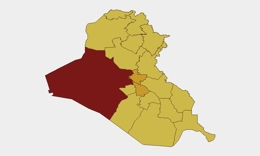
Iraq remains at elevated risk (composite threat score 99; #12 globally), with 351 tracked events reflecting persistent inter-state tensions, domestic security fragmentation, and localized armed activity. Recent signals show friction between Iraq, Iran, France, and the United States—compounded by Marine Corps/military engagement and diplomatic disapproval statements—indicating a volatile near-term environment. Al-Anbar Governorate dominates the risk profile at 99.5, while Baghdad (72.5) and central/southern governorates cluster between 69.5–71.5, signaling dispersed rather than concentrated threat geography. The security picture is characterized by instability without immediate systemic collapse, but with multiple triggering events active within a 72-hour window.
Key Developments
- 2026-06-25 · Small Arms Combat, Baghdad-vicinity (France–Iraq actors). Armed engagement between French and Iraqi forces occurred on 2026-06-23; ongoing diplomatic fallout continues with public statements on 2026-06-24–25.
- 2026-06-25 · David Petraeus Disapproval Statement. Former General Petraeus issued disapproval regarding Iraq on 2026-06-25, context and target unclear from available signals but flagged as recent diplomatic/analytical friction.
- 2026-06-22–23 · Iran–Iraq Threat and Counter-Statement. Iran threatened Iraq on 2026-06-22; Iraq issued disapproval of Iran on 2026-06-23, indicating escalating verbal/diplomatic posturing.
- 2026-06-23 · Unconventional Violence, Marine Corps engagement. U.S. Marine Corps engaged in unconventional violence activity on 2026-06-23; location and details pending clarification.
- 2026-06-23 · Investigative Actions by Iraq. Iraq initiated investigations into Algeria and internal military actors on 2026-06-23, suggesting internal security operations or alliance-friction inquiries.
- 2026-06-24–25 · Multi-Actor Public Statements. Iraq issued public statements against the United States (2026-06-24), a diplomat (2026-06-25), and Australia (2026-06-25), indicating rapid diplomatic messaging and potential coalition fracture.
Highest-Risk Areas
Al-Anbar Governorate (99.5) is the primary flashpoint, likely driven by ISIS-affiliated residual activity, tribal instability, and Syrian-border dynamics. Baghdad (72.5) concentrates governance, foreign diplomatic presence, and militia activity, making it a natural secondary node of risk. The cluster of governorates at 69.5–71.5 (Kirkuk, Wasit, Babil, Karbala, and the southern tier) reflects fragmented armed-group presence, Shia militia networks, and inter-provincial resource/political competition. This distributed risk profile suggests threats are not localized but embedded across supply lines, transit corridors, and administrative boundaries.
How GeoBit Would Assist
Security teams should employ Intel Sweep and OSINT Fusion to corroborate the diplomatic incidents and military engagements flagged above, isolating actor identities and tactical intent. AOI Monitoring & Early Warning with persistent watch on Al-Anbar, Baghdad, and Kirkuk would provide 48–72 hour advance notice of escalation in armed activity or personnel movement. Routing & Network Analysis would allow duty-of-care teams to evaluate safe corridors, identify checkpoints and militia positions, and plan evacuation or relocation routes. Conflict & Military capability (force structure, weapons tracking) helps assess whether recent engagements represent isolated incidents or coordinated escalation.
7-Day Outlook
Inter-state tensions (France, Iran, U.S.) are likely to remain elevated through diplomatic channels, with lower probability of direct kinetic escalation in the next 72 hours. Domestic security operations (Iraqi investigations of military/Algeria) suggest internal consolidation efforts, which may reduce external-facing violence in the short term. Risk trajectory is stable-to-rising, with Baghdad and Al-Anbar as flashpoints warranting continuous monitoring.
Highest-Risk Areas — Ranked
| # | State / Region | Risk |
|---|---|---|
| 1 | Al-Anbar Governorate | 99.5 |
| 2 | Baghdad Governorate | 72.5 |
| 3 | Babil Governorate | 71.5 |
| 4 | Karbala | 70 |
| 5 | Kirkuk Governorate | 69.7 |
| 6 | Wasit Governorate | 69.5 |
| 7 | Al-Qadisiyah Governorate | 69.5 |
| 8 | Dhi Qar Governorate | 69.5 |
| 9 | Al-Muthanna Governorate | 69.5 |
| 10 | Maysan Governorate | 69.5 |
| 11 | Al-Basra Governorate | 69.5 |
| 12 | Al-Najaf Governorate | 69.5 |
Previous Daily Briefs
A new Iraq brief is written every day — each with its own risk map and downloadable CSV. Here's the last week; use the calendar to go further back.
📅 Browse every day by calendar →
Highlighted days have a brief. Tap a day for that day's map & analysis, or “csv” for that day's dataset ($5).