Situation Summary
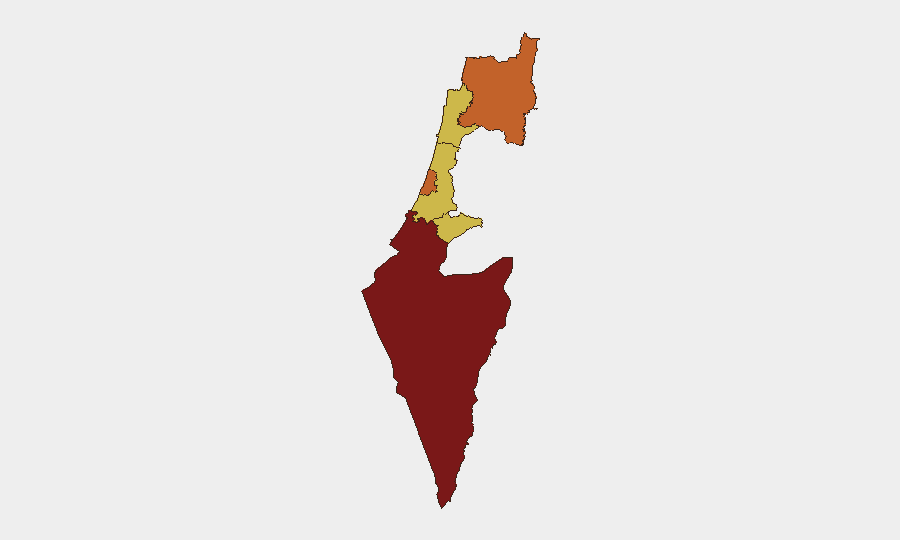
Israel remains at threat level #6 globally (composite score 100), driven by active multi-front military engagement. The past 48 hours show sustained conventional military operations involving Iran, Lebanon, and internal military mobilization, with 388 tracked events in the current cycle. The South District remains the highest-risk zone (score 100), followed by Tel Aviv, North, and Haifa districts (70–75.3), reflecting both geographic proximity to conflict zones and urban concentration. Trajectory is toward sustained rather than de-escalating tension.
Key Developments
- Southern Lebanon / Nabatieh — 26 June 2026: Israeli strikes hit the town of Nabatieh and adjacent villages following Hezbollah rocket exchanges; civilian casualties reported in Lebanon. Cross-border fire-exchange pattern continues with no immediate ceasefire signals.
- Israel-Iran Military Exchange — 25–26 June 2026: Signal events recorded as "Reject" (25 June) and "Conventional Military Force" (26 June) indicate direct or proxy military action; exact scope and location require real-time intelligence corroboration.
- Lebanon Demand / Threat Exchange — 26–27 June 2026: Lebanon issued formal demand (27 June); Israel issued threat response (26 June), marking escalated diplomatic-military posture typical of pre-or-during-active conflict phases.
- Israeli Military Mobilization — 26 June 2026: Tracked signal of internal military mobilization ("ISRAEL vs MILITARY") suggests force deployment or readiness increase; extent and duration unknown from open signals.
- UN and Conventional Force Events — 26 June 2026: UN involvement recorded alongside Israeli conventional military force signals, indicating either UN condemnation, observer presence, or diplomatic intervention attempts concurrent with operations.
- Domestic Unrest Signal — 25 June 2026: "Arrest/Detain" and "Investigate" signals involving Israeli subjects and company actors suggest internal security or protest-related activity; scale and location require clarification.
Highest-Risk Areas
South District (100) dominates risk due to direct proximity to Gaza and southern Lebanon conflict zones, making it the primary theater for cross-border fire and military operations. Tel Aviv, North, and Haifa districts (70–75.3) are elevated due to population density, critical infrastructure, and range of rocket/drone threat from both Lebanon and Iranian proxies. Jerusalem, Center, and Haifa districts at 70 reflect both symbolic/administrative importance and secondary strike risk. Risk is *geographic and operational*, not uniformly distributed; duty-of-care teams should prioritize South and Tel Aviv for immediate exposure review.
How GeoBit Would Assist
Intel Sweep and OSINT Fusion would consolidate fragmented signals (Iran, Lebanon, internal mobilization) into a coherent operational picture via multi-language sources, X/Telegram OSINT, and real-time event corroboration. AOI Monitoring & Early Warning on South District, border crossings, and Haifa/Tel Aviv critical nodes would generate persistent alerts on movement, military activity, and escalation triggers. Routing & Network Analysis would enable alternative journey planning and facility access routes for at-risk personnel, bypassing known strike zones and checkpoints. Satellite & Imagery analysis and Conflict & Military battle mapping would provide ground-truth on active operational areas, force positioning, and collateral-damage risk zones.
7-Day Outlook
Military operations are likely to sustain or intensify over the next 7 days absent a diplomatic breakthrough; no ceasefire signals are present. South District and cross-border zones (Lebanon, Gaza perimeter) will remain highest-risk for personnel and logistics. Corporate security teams should assume restricted movement, possible curfews, and air-raid alert cycles in high-risk districts; supply-chain and evacuation contingencies should be tested now.
Highest-Risk Areas — Ranked
| # | State / Region | Risk |
|---|---|---|
| 1 | South District | 100 |
| 2 | Tel-Aviv District | 75.3 |
| 3 | North District | 73.3 |
| 4 | Haifa District | 70 |
| 5 | Center District | 70 |
| 6 | Jerusalem District | 70 |
Sources
Previous Daily Briefs
A new Israel brief is written every day — each with its own risk map and downloadable CSV. Here's the last week; use the calendar to go further back.
📅 Browse every day by calendar →
Highlighted days have a brief. Tap a day for that day's map & analysis, or “csv” for that day's dataset ($5).