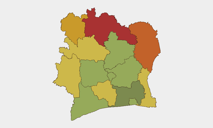
Situation Summary
Ivory Coast remains at moderate global threat ranking (#61, composite score 30) with security risks concentrated in the northern border districts and dispersed across rural savanna regions. The country's primary vulnerabilities stem from cross-border terrorism pressure from Mali and Burkina Faso, localized communal tensions, and critical infrastructure fragility, as evidenced by recent water-supply disruptions in the capital. The security environment is stable relative to regional peers but requires sustained monitoring in frontier zones and vigilance around political constituencies.
Key Developments
- Abidjan, 20 July 2026 — A technical failure at a drinking-water production facility operated by SODECI disrupted water supply across multiple neighborhoods in the capital. Service restoration was underway at time of reporting; no timeline provided for full recovery. This incident underscores infrastructure vulnerability and potential cascading impact on business continuity and public services.
- Cross-border zones (Mali/Burkina Faso frontier), standing advisory — The German Foreign Ministry maintains a non-essential travel warning for immediate border areas near Comoé National Park and the Bouna region, reflecting latent but unresolved terrorism risk and reports of civilian-targeting violence. No new specific incident was confirmed in the last 48 hours, but the advisory reflects persistent threat activity in these zones.
- Political messaging, national level — Two public statements attributed to DEPUTY entities on 21 July 2026 reference both "AFRICA" and "CÔTE D'IVOIRE" contexts, indicating ongoing political communication or commentary; full content and attribution require clarification to assess operational significance.
Highest-Risk Areas
The northern frontier districts—Savanes (78), Zanzan (75), Denguélé (72), and Comoé (70)—dominate the risk landscape and account for the majority of threat drivers. These regions face persistent cross-border infiltration by Mali and Burkina Faso-based armed groups, weak state presence, and porous terrain favorable to smuggling and irregular movement. Montagnes (68) and Woroba (65) districts extend this northern vulnerability arc southward. By contrast, Abidjan (45) and southern coastal zones register significantly lower composite risk, though they remain subject to infrastructure fragility and localized crime; they remain essential for business and diplomatic operations and require standard protective measures rather than heightened alert posture.
How GeoBit Would Assist
Security teams operating in Ivory Coast would benefit from AOI Monitoring & Early Warning focused on northern border districts (Savanes, Zanzan, Denguélé, Comoé) with persistent satellite and OSINT feeds to detect armed-group movement, unauthorized crossings, and civilian-targeting incidents. Intel Sweep and multi-language OSINT fusion (X, Telegram, local media) would provide real-time situational updates on political messaging, criminal activity, and infrastructure disruptions affecting Abidjan and regional offices. Routing & Network Analysis would support alternative transportation and supply-chain planning during periods of heightened border tension or infrastructure outage.
7-Day Outlook
No major escalation is anticipated in the near term, but the security baseline remains volatile in northern zones. Water infrastructure resilience in Abidjan warrants monitoring, as repeated disruptions could signal deeper system stress or create secondary security risks (crowding at distribution points, service-sector disruption). Border-region threat activity is expected to remain episodic and localized; significant escalation would likely emerge via OSINT and local reporting 3–5 days in advance of major incidents.
Highest-Risk Areas — Ranked
| # | State / Region | Risk |
|---|---|---|
| 1 | Savanes District | 78 |
| 2 | Zanzan District | 75 |
| 3 | Denguélé District | 72 |
| 4 | Comoé District | 70 |
| 5 | Montagnes District | 68 |
| 6 | Woroba District | 65 |
| 7 | Gôh-Djiboua District | 60 |
| 8 | Sassandra-Marahoué District | 58 |
| 9 | Vallée du Bandama District | 55 |
| 10 | Bas-Sassandra District | 52 |
| 11 | Lacs District | 48 |
| 12 | Abidjan | 45 |
Previous Daily Briefs
A new Ivory Coast brief is written every day — each with its own risk map and downloadable CSV. Here's the last week; use the calendar to go further back.
📅 Browse every day by calendar →
Highlighted days have a brief. Tap a day for that day's map & analysis, or “csv” for that day's dataset ($5).
Atlas — our AI intelligence desk — emails them this snapshot personally. Nothing else, no list.