Situation Summary
Lebanon remains in active conflict following a major escalation on 25–26 June 2026, with Israeli airstrikes intensifying across southern Lebanon and the Bekaa Valley despite a U.S.–Iran ceasefire memorandum signed on 25 June. At least 16 people were killed in overnight strikes on Nabatiih alone, and scores more have died in aerial operations targeting civilian and military infrastructure. Hezbollah continues ground operations against Israeli forces in southern Lebanon, and contradictory statements from U.S. and Lebanese officials regarding Israeli troop withdrawal have created ambiguity about ceasefire compliance and on-the-ground intent. The composite threat score of 79 and "active war" designation reflect sustained kinetic operations, civilian casualties, and an unpredictable trajectory despite diplomatic frameworks.
Key Developments
- Zawtar–Mayfadoun road, Nabatieh Governorate – 25 June 2026: Israeli airstrike on a civilian vehicle killed three people and injured one, according to Lebanon's National News Agency.
- Ain Arab area, southern Lebanon – 24–25 June 2026: Israeli forces ordered evacuation of residents by 17:00 local time, then torched multiple homes in the locality, per Lebanon's National News Agency.
- Southern Lebanon (multiple localities) – 24–25 June 2026: Israeli military reported striking over 200 Hezbollah targets within a 24-hour window, including infrastructure and forward positions, during ongoing U.S.–Iran ceasefire diplomacy.
- Nabatiih, Nabatieh Governorate – night of 25 June 2026: Israeli airstrikes killed at least 16 people with additional casualties trapped under rubble; smoke reported over the city following overnight attacks.
- Southern Lebanon – 25 June 2026: Drone strike killed at least one person hours after the U.S.–Iran memorandum of understanding was signed, suggesting continued operations despite ceasefire intent.
- Southern Lebanon security zone – 25–26 June 2026: U.S. State Department official told Reuters that Israel has withdrawn from part of the southern "security zone," but a Lebanese military official publicly denied any withdrawal, stating Israeli occupation forces remain in place.
- Tyre and Nabatieh districts, South & Nabatieh Governorates – 24–26 June 2026: Expanded Israeli air operations have forced residents to flee; numerous civilians reported killed during escape attempts on roads.
- Southern Lebanon frontline – 24–26 June 2026: Hezbollah claimed approximately 20 attacks on Israeli troops in recent hours, with Israeli reporting confirming multiple Hezbollah operations targeting its forces.
Highest-Risk Areas
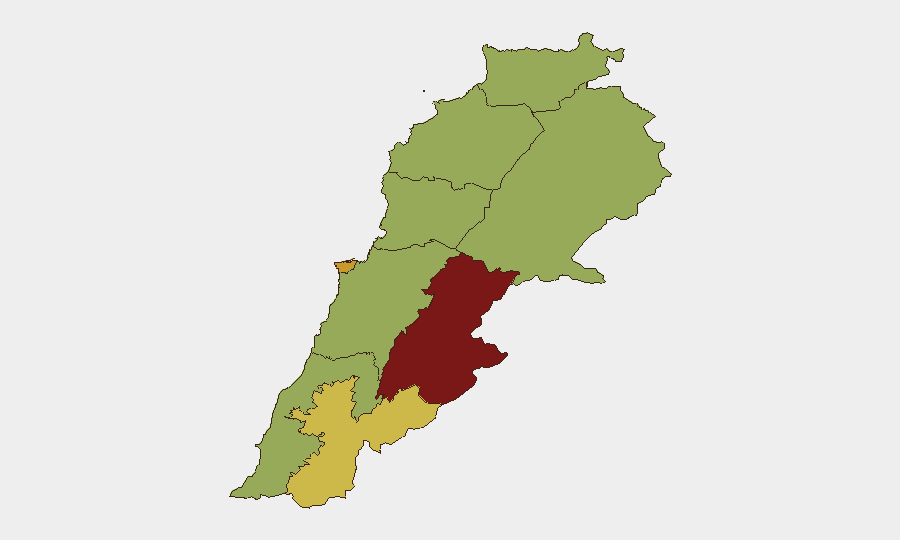
Beqaa Governorate (85.3) dominates the sub-national ranking, driven by its geography as a traditional Hezbollah stronghold and logistics corridor that Israeli operations have systematically targeted. Beirut Governorate (72.1) ranks second, reflecting both proximity to conflict zones and political/administrative importance; civilian infrastructure and population density amplify consequence risk. Nabatiih Governorate (60) has emerged as an acute flashpoint over the past 48 hours, with documented airstrikes, ground operations, and civilian displacement. The remaining governorates (South, North, Akkar, Mount Lebanon, Keserwan-Jbeil, Baalbek-Hermel) cluster at 55.3, indicating widespread but lower-intensity exposure; however, escalation can rapidly shift these rankings.
How GeoBit Would Assist
AOI Monitoring & Early Warning would provide persistent watch on Beqaa and southern Lebanon with automated alerting when airstrikes, military movements, or displacement events occur. Battle Mapping and force-structure tracking would clarify Israeli and Hezbollah positions, ceasefire compliance, and tactical intent. Conflict & Military intelligence, combined with Intel Sweep and multi-language OSINT fusion, would resolve contradictions (e.g., U.S. vs. Lebanese statements on troop withdrawal) and flag imminent operations. Routing & Network Analysis would identify safe corridors and alternative transport for personnel and asset evacuation.
7-Day Outlook
Without sustained ceasefire enforcement or a de-escalation agreement with explicit monitoring mechanisms, kinetic operations are likely to continue in southern Lebanon and the Bekaa Valley, with periodic spikes coinciding with retaliatory cycles. Civilian displacement will accelerate, particularly from Nabatiih, Tyre, and surrounding areas. Risk of miscalculation or unilateral escalation remains high given the gap between diplomatic statements and ground reality.
Highest-Risk Areas — Ranked
| # | State / Region | Risk |
|---|---|---|
| 1 | Beqaa Governorate | 85.3 |
| 2 | Beirut Governorate | 72.1 |
| 3 | Nabatieh Governorate | 60 |
| 4 | North Governorate | 55.3 |
| 5 | Akkar Governorate | 55.3 |
| 6 | Keserwan-Jbeil Governorate | 55.3 |
| 7 | Mount Lebanon Governorate | 55.3 |
| 8 | South Governorate | 55.3 |
| 9 | Baalbek-Hermel Governorate | 55.3 |
Sources
Previous Daily Briefs
A new Lebanon brief is written every day — each with its own risk map and downloadable CSV. Here's the last week; use the calendar to go further back.
📅 Browse every day by calendar →
Highlighted days have a brief. Tap a day for that day's map & analysis, or “csv” for that day's dataset ($5).