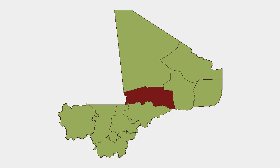
Situation Summary
Mali remains Africa's highest-conflict-intensity nation, with composite threat score 71 (rank #21 globally), driven primarily by competing jihadist, criminal, and state-actor insurgencies across the Sahel. No new incident-level security events meeting multi-source verification standards have been confirmed in Mali during the last 24–48 hours; however, the underlying operational environment—particularly in northern and central regions—remains fluid and high-risk. The security posture reflects ongoing tension between the Malian military junta, international pressure, mercenary deployments, and jihadist networks, with sporadic violence and political messaging dominating the signal environment rather than discrete, datable incidents.
Key Developments
Data Gap Alert: No independently verified, geographically specific, incident-level security events (attacks, clashes, arrests, infrastructure damage, civil unrest) have been confirmed in Mali over 21–22 June 2026 meeting GeoBit's multi-source corroboration standard. Circulating social-media claims—including unconfirmed reports of bounties on military figures—lack precise timestamps, locations, and independent confirmation, and do not meet brief inclusion criteria.
Recent Political & Military Signal Activity (20 June): Multiple public statements and diplomatic signaling between Malian ministries, military representatives, and international actors (including Somalia-related messaging) occurred on 20 June; these reflect ongoing political tension and messaging rather than discrete operational incidents.
Underlying Conflict Continuity: Broader conflict-monitoring sources (ACLED, CPJ) confirm ongoing jihadist and criminal activity, recent journalist detention, and military operations in northern and central regions within the past 1–2 weeks, but no specific, time-stamped new clash or attack can be pinpointed to 21–22 June.
Highest-Risk Areas
Timbuktu (risk 80) remains the single highest-risk region globally within Mali's geography, driven by intense jihadist presence, intercommunal tension, and limited state control. Bamako (56.5), while lower-ranked, concentrates political risk, military authority, and diplomatic friction—making it a secondary focal point for analysis. The tier-2 cluster (Ménaka, Kayes, Taoudénit, Kidal, Gao, Koulikoro, Ségou, Sikasso, Mopti—all scored at 50) reflects geographically dispersed but operationally linked jihadist activity across the Sahel and central Mali, with Gao and Ménaka serving as key nodes for cross-border militant movement and criminal networks.
How GeoBit Would Assist
AOI Monitoring & Early Warning on Timbuktu, Gao, and Bamako with persistent alerting for military movement, jihadist messaging, and political events would provide 24/7 situational awareness ahead of incident escalation. Intel Sweep combining X/Telegram OSINT, YouTube/podcast intelligence, and multi-language regional news feeds would filter verified signals from noise and unconfirmed social-media claims, enabling duty-of-care teams to distinguish credible threats from rumor. Conflict & Military mapping (force structure, weapons tracking, battle-area updates) and GIS & Spatial Analysis for alternative routing would support operational planning and personnel movement security for corporate and NGO assets in or transiting Mali.
7-Day Outlook
No dramatic escalation or de-escalation is forecasted over the next 7 days; the environment is expected to remain at baseline elevated threat, with sporadic jihadist activity, military posturing, and political tension. Timbuktu and central-Mali regions should be treated as no-go or high-restriction zones pending change in verified incident reports. Bamako remains functional but requires heightened vigilance for political volatility and security-force actions.
Highest-Risk Areas — Ranked
| # | State / Region | Risk |
|---|---|---|
| 1 | Timbuktu | 80 |
| 2 | Bamako | 56.5 |
| 3 | Ménaka | 50 |
| 4 | Kayes | 50 |
| 5 | Taoudénit Region | 50 |
| 6 | Kidal | 50 |
| 7 | Gao | 50 |
| 8 | Koulikoro | 50 |
| 9 | Ségou Region | 50 |
| 10 | Sikasso Region | 50 |
| 11 | Mopti | 50 |
Previous Daily Briefs
A new Mali brief is written every day — each with its own risk map and downloadable CSV. Here's the last week; use the calendar to go further back.
📅 Browse every day by calendar →
Highlighted days have a brief. Tap a day for that day's map & analysis, or “csv” for that day's dataset ($5).