Situation Summary
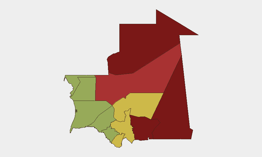
Mauritania remains a low-frequency threat environment globally (rank #145, composite score 8) with no discrete security incidents recorded in the current tracking window. However, sub-national risk is heavily concentrated in the Saharan north and east—Tiris Zemmour, Hodh Ech Chargui, and Hodh El Gharbi—where border porosity, militant activity, and ungoverned space create persistent operational hazard. The country's security posture is stable but fragmented by geography; southern and coastal regions present materially lower risk to personnel and assets.
Key Developments
- Amhijrat, northwest coast — 2026-08-27: Mauritanian coast guard rescued 161 migrants, including 17 children, from a vessel in distress. The incident reflects sustained irregular maritime migration pressure and associated search-and-rescue operations along Mauritania's Atlantic approaches, a known transit route to Europe.
*Note: No additional discrete security incidents were corroborated for the 24–48 hour window. Maritime migration and irregular transit represent the principal current operational signal.*
Highest-Risk Areas
Tiris Zemmour (risk 95) and Hodh Ech Chargui (risk 85) dominate the risk profile and warrant primary focus for duty-of-care planning. Both regions occupy Mauritania's northeastern border with Mali and Algeria, characterized by sparse settlement, limited state presence, cross-border militant sanctuaries, and trafficking corridors. Hodh El Gharbi (risk 80) and Adrar (risk 78) extend this frontier hazard southward and westward. Together, these four regions account for the vast majority of kidnapping, armed group activity, and asymmetric threat in Mauritania; personnel and supply chains transiting or operating in these zones face elevated exposure. By contrast, the southern and coastal belts—including Nouakchott and Dakhlet Nouadhibou—present substantially lower risk profiles and remain viable for standard corporate security protocols.
How GeoBit Would Assist
Security teams managing Mauritania exposure should employ AOI Monitoring & Early Warning on the high-risk northern regions (Tiris Zemmour, Hodh Ech Chargui) to detect militant movement, cross-border incursions, or kidnap activity in real time. Conflict & Military tracking and Network & Actor Analysis would establish baseline force-structure and militant-group disposition across the Saharan frontier. Routing & Network Analysis supports alternative journey planning and safe-passage assessment for personnel or logistics transiting the interior. For maritime supply chains or evacuation contingency, Maritime & Aviation tracking and satellite imagery analysis provide current visibility on coastal and offshore conditions, particularly relevant given the Amhijrat rescue and ongoing irregular-migration pressure.
7-Day Outlook
No immediate escalation is forecast; Mauritania's overall threat environment remains episodic rather than endemic. However, seasonal cross-border activity from Mali and Algeria into the northern regions typically increases during autumn months, and the coast-guard rescue signals continued irregular-migration transit risk. Security teams should maintain heightened monitoring posture in Tiris Zemmour and Hodh Ech Chargui and confirm staff-safety protocols for any necessary northern operations.
Highest-Risk Areas — Ranked
| # | State / Region | Risk |
|---|---|---|
| 1 | Tiris Zemmour | 95 |
| 2 | Hodh Ech Chargui | 85 |
| 3 | Hodh El Gharbi | 80 |
| 4 | Adrar | 78 |
| 5 | Tagant | 68 |
| 6 | Guidimaka | 65 |
| 7 | Assaba | 62 |
| 8 | Gorgol | 58 |
| 9 | Trarza | 55 |
| 10 | Inchiri | 52 |
| 11 | Brakna | 48 |
| 12 | Dakhlet Nouadhibou | 45 |
Sources
Previous Daily Briefs
A new Mauritania brief is written every day — each with its own risk map and downloadable CSV. Here's the last week; use the calendar to go further back.
- August 26, 2026
- August 24, 2026
- August 22, 2026
- August 20, 2026
- August 18, 2026
- August 16, 2026
- August 14, 2026
📅 Browse every day by calendar →
Highlighted days have a brief. Tap a day for that day's map & analysis, or “csv” for that day's dataset ($5).
Atlas — our AI intelligence desk — emails them this snapshot personally. Nothing else, no list.