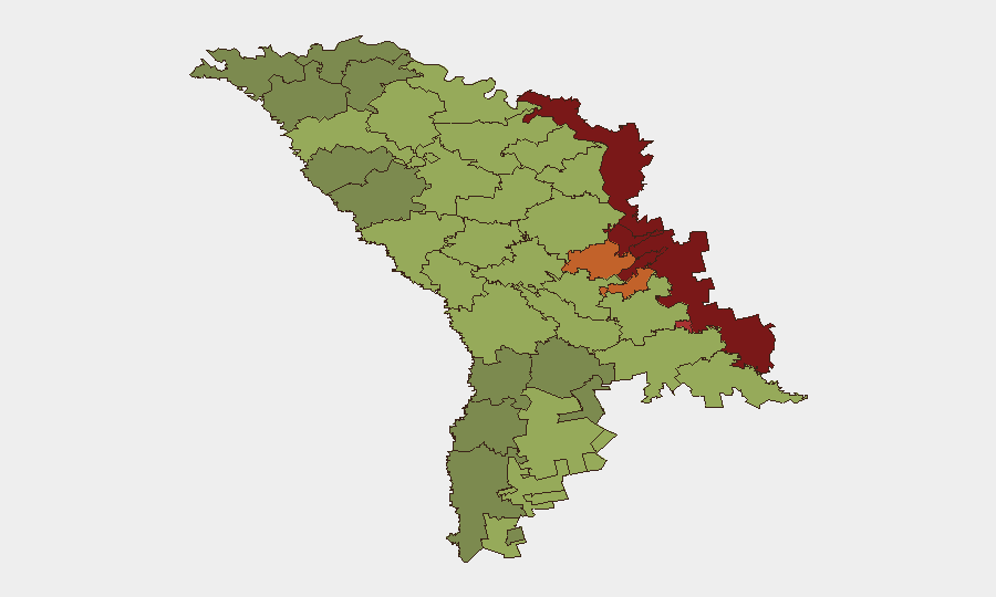
Situation Summary
Moldova remains a low-threat country overall (rank #156 globally) but faces materially elevated border and airspace risks due to proximity to ongoing Russian-Ukrainian conflict. Over the past 48 hours, multiple unidentified drone incursions have been detected crossing or briefly transiting Moldovan airspace, with confirmed damage to cross-border infrastructure on the Ukraine side affecting transit operations. The risk environment is characterized by spillover effects rather than direct threats to Moldova's sovereignty, but border-crossing disruptions and drone debris recovery operations underscore the volatility of the immediate frontier zone.
Key Developments
- Ștefan Vodă district, Palanca–Tudora area (26 Aug, 17:38–17:43) – An unidentified drone entered Moldovan airspace during a Russian air attack on Ukraine, detected for approximately 5 minutes near Palanca before exiting toward Tudora. No damage or debris reported on Moldovan territory.
- Vulcănești–Vynohradivka crossing, Ukraine–Moldova border (25–26 Aug) – Russian Shahed drones struck the Vynohradivka international road checkpoint on the Ukrainian side, temporarily suspending cross-border traffic. Operations resumed on 26 Aug following temporary repairs, restoring vehicle and pedestrian passage.
- Cahul district, southern airspace near Pașcani (night of 24 Aug, updated 26 Aug) – An unidentified drone overflew southern Moldovan airspace en route to Romania; Moldovan airspace was briefly restricted (15 minutes) as a precaution before reopening. No damage reported.
- Cahul district, Giurgiulești area (20 Aug incidents, investigative update 26 Aug) – Remains of a Geran-type drone were recovered approximately 1 km inside Moldovan territory following Russian strikes on Ukrainian port infrastructure at Reni; ongoing investigation and forensic analysis.
- Moldova-wide border infrastructure (August 2026 pattern, assessed 26 Aug) – Russian forces have intensified strikes on Ukrainian and Moldovan border crossings to disrupt export routes and create instability; multiple crossings including Vynohradivka–Vulcănești and Tabaky have experienced temporary closures and damage.
- Cross-border criminal enforcement (end of August, reported 26 Aug) – Moldovan Interior Ministry and Fulger special forces detained four men for 72 hours in connection with an assault case in Czech Republic; a fifth suspect identified. Operation underscores active law-enforcement cooperation and arrest activity on Moldovan territory.
Highest-Risk Areas
The Left Bank of the Dniester (Transnistria region, risk score 85) and the municipalities of Dubăsari (82) and Bender (79) dominate the sub-national risk ranking, reflecting the confluence of disputed territorial control, Russian military presence, and proximity to active conflict zones. Ștefan Vodă (51) and Cahul (south-border districts) rank moderately but show acute sensitivity to drone spillover and border infrastructure damage. The capital, Chișinău (49), remains below the highest-risk threshold; however, the elevation of southern and eastern border districts reflects the current operational tempo of Russian air operations targeting Ukrainian logistics routes that transit near or through Moldovan territory.
How GeoBit Would Assist
Security teams should deploy AOI Monitoring & Early Warning on eastern and southern border zones (Ștefan Vodă, Cahul, Dubăsari) to detect and alert on drone incursions and infrastructure incidents in real time. OSINT fusion and multi-language search (Telegram, local news, official ministry releases) enable rapid corroboration of drone sightings and damage reports. Routing & Network Analysis can identify alternative cross-border transit corridors and assess impact of temporary crossing closures on supply chains and personnel movement.
7-Day Outlook
Drone incursions are likely to remain episodic as Russian air operations against Ukraine continue; however, no direct targeting of Moldovan territory is currently assessed. Border crossing closures are expected to be temporary and localized. Risk remains primarily spillover-related rather than indicative of expanded Russian intent toward Moldova.
Highest-Risk Areas — Ranked
| # | State / Region | Risk |
|---|---|---|
| 1 | Administrative-Territorial Units of the Left Bank of the Dniester | 85 |
| 2 | Dubăsari | 82 |
| 3 | Bender | 79 |
| 4 | Criuleni | 75 |
| 5 | Rezina | 58 |
| 6 | Taraclia | 55 |
| 7 | Gagauzia | 54 |
| 8 | Căușeni | 53 |
| 9 | Soroca | 52 |
| 10 | Ștefan Vodă | 51 |
| 11 | Orhei | 50 |
| 12 | Chișinău | 49 |
Sources
Previous Daily Briefs
A new Moldova brief is written every day — each with its own risk map and downloadable CSV. Here's the last week; use the calendar to go further back.
- August 24, 2026
- August 22, 2026
- August 20, 2026
- August 18, 2026
- August 15, 2026
- August 13, 2026
- August 11, 2026
📅 Browse every day by calendar →
Highlighted days have a brief. Tap a day for that day's map & analysis, or “csv” for that day's dataset ($5).
Atlas — our AI intelligence desk — emails them this snapshot personally. Nothing else, no list.