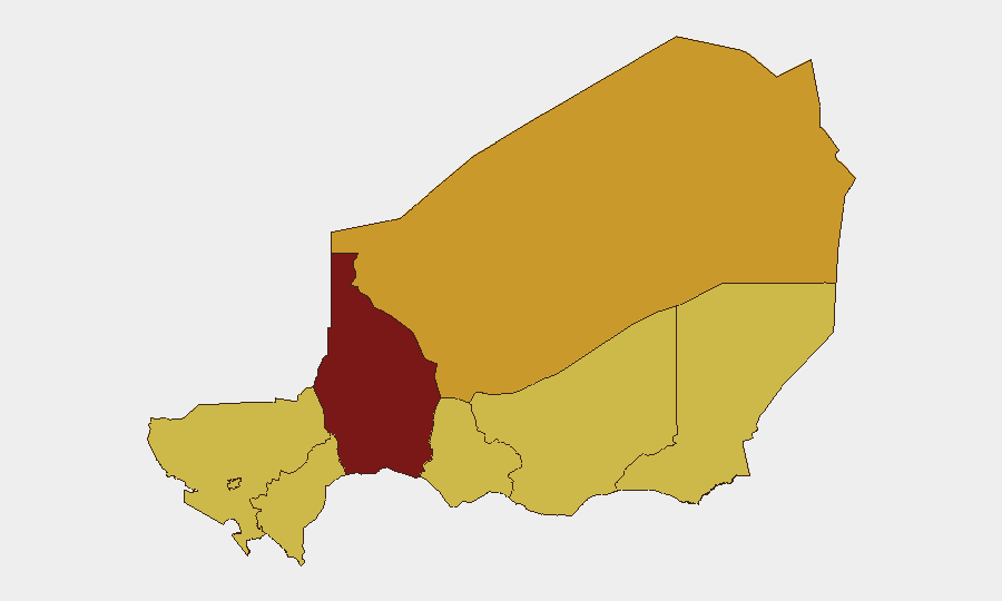
Situation Summary
Niger remains at elevated operational risk, ranked #22 globally with a composite threat score of 97. The security environment is shaped by persistent jihadist activity in the Sahel—particularly Islamic State Sahel Province (ISSP) and Jama'at Nusrat al-Islam wal-Muslimin (JNIM) operations—coupled with localized criminal activity and transnational border tensions. Recent diplomatic friction involving Nigeria and regional actors signals potential secondary spillover into cross-border security operations. The threat trajectory remains volatile, with insurgent cells maintaining capability to conduct attacks across multiple regions.
Key Developments
Constraint on current incident reporting: GeoBit's live web research (last 24–48 hours) has identified diplomatic and political statements involving Niger and neighboring states (Nigeria, Algeria, Ghana) dated 2026-06-26 and 2026-06-25, but cannot yet corroborate specific tactical security incidents within Niger's borders during this narrow window with multi-source confirmation. Earlier June 2026 events (jihadist operations in Tillabéri and at Niamey airport, reported 2026-06-17 to 2026-06-18) remain the most recent verified incidents but fall outside the 24–48-hour reporting frame.
Recommendation: Security teams should treat the platform's flagged diplomatic statements (PRESIDENT vs NIGERIA, NIGER vs ALGERIA) as potential harbingers of increased military or security activity rather than direct tactical threats at this time. Detailed incident bulletins will be issued once GeoBit's multi-source corroboration confirms specific events within the reporting window.
Highest-Risk Areas
Tahoua Region stands substantially above all others with a composite risk score of 97.8, driven by persistent ISSP and JNIM activity, limited state security presence, and difficult terrain that enables insurgent safe havens and logistics networks. Agadez Region (72.8) and Niamey (69.1) follow, with Agadez facing transnational smuggling and militant transit routes, and the capital exposed to intelligence collection, political instability, and potential asymmetric attacks. The remaining regions (Zinder, Diffa, Tillabéri, Dosso, Maradi—all 67.8) form a secondary risk band reflecting baseline jihadist presence, criminal activity, and border permeability. Companies and NGOs with operations in Tahoua should prioritize enhanced access control, staff movement restrictions, and liaison with local authorities.
How GeoBit Would Assist
Security teams protecting personnel and assets in Niger should deploy AOI Monitoring & Early Warning on Tahoua Region and Niamey to receive alerts on jihadist attack patterns, checkpoint activity, and movement anomalies. Routing & Network Analysis can identify safer alternative supply lines and staff transit corridors around known militant zones and criminal checkpoints. Intel Sweep, multi-language OSINT, and Telegram/X intelligence enable continuous monitoring of militant communications, regional diplomatic developments, and cross-border military operations that may escalate local risk.
7-Day Outlook
Tahoua Region is expected to remain the primary operational threat focus; no strategic change in jihadist capability or intent is anticipated in the immediate term. Regional diplomatic tensions (Nigeria, Niger, Algeria) may prompt increased military activity near borders, potentially constraining movement and complicating logistics. Security posture should remain heightened; any sudden escalation in diplomatic or military signaling warrants real-time re-assessment via targeted OSINT.
Highest-Risk Areas — Ranked
| # | State / Region | Risk |
|---|---|---|
| 1 | Tahoua Region | 97.8 |
| 2 | Agadez Region | 72.8 |
| 3 | Niamey | 69.1 |
| 4 | Zinder Region | 67.8 |
| 5 | Diffa Region | 67.8 |
| 6 | Tillabéri Region | 67.8 |
| 7 | Dosso Region | 67.8 |
| 8 | Maradi Region | 67.8 |
Sources
Previous Daily Briefs
A new Niger brief is written every day — each with its own risk map and downloadable CSV. Here's the last week; use the calendar to go further back.
📅 Browse every day by calendar →
Highlighted days have a brief. Tap a day for that day's map & analysis, or “csv” for that day's dataset ($5).