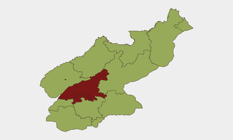
Situation Summary
North Korea remains at elevated military posture, with state-controlled reporting confirming stepped-up weapons testing and naval capability demonstrations over the past 48 hours. South Korea and the United States have responded with coordinated missile exercises in contested waters, signaling acute tension in the peninsula's military balance. No credible open-source reporting indicates civil unrest, public disorder, or changes to border/travel restrictions inside North Korea, though information controls make ground-level assessment difficult. The overall composite threat score (79, rank #23 globally) reflects primarily state-level military activity rather than imminent risk to civilian populations or foreign personnel.
Key Developments
- Pyongyang & East Coast (Wonsan area) – June 23–24, 2026: North Korea's armed forces conducted weapons tests and public military displays, per KCNA state media; concurrent reporting indicates a North Korean missile launch into waters off the peninsula, triggering a joint South Korean–U.S. retaliatory missile exercise in the same zone and characterized by allied capitals as "reckless."
- North Korean Strategic Fleet Facilities – June 23–24, 2026: State sources report deployment of a new destroyer and reaffirmation of a nuclear-powered naval development program announced within the last 24 hours, consistent with broader escalation in military showcase activity.
- Regional Military Response – June 24, 2026: South Korea and the United States fired missiles into contested waters in explicit protest of the North Korean test, underscoring heightened allied readiness and elevated risk of miscalculation in disputed maritime zones.
Highest-Risk Areas
South Pyongan (85.2) and Pyongyang (82.4) dominate the sub-national risk ranking and reflect concentration of military command, weapons development, and state-security apparatus in those provinces. Pyongyang's elevated score correlates with the capital's role as the seat of regime authority and weapons-test coordination; South Pyongan's higher risk likely reflects proximity to military test ranges and strategic infrastructure. The remaining ten provinces cluster at 55–59.3, indicating that acute military and strategic risks are geographically concentrated in the northwest and capital region, while other areas present baseline, chronic hardship risks rather than acute event-driven threats. Nampo (59.3), as a strategic port, reflects naval activity monitoring; all other provinces score uniformly lower and are not currently driving overall national threat elevation.
How GeoBit Would Assist
Security teams with North Korea exposure should deploy AOI Monitoring & Early Warning on Pyongyang, South Pyongan, and east-coast launch facilities (Wonsan area) to track military activity, weapons tests, and regime communications in near-real time. OSINT fusion (Intel Sweep, KCNA state-media feeds, multi-language search, and sentiment analysis) provides early detection of regime messaging shifts, evacuation directives, or changes to foreign-personnel restrictions that open-source reporting often misses. Satellite & Imagery analysis and conflict mapping offer ground truth on military deployments and border posture changes independent of state media spin, critical for duty-of-care decisions affecting personnel in border zones or Pyongyang.
7-Day Outlook
The weapons-test cycle and allied response are likely to persist over the near term, with both Pyongyang and Seoul–Washington maintaining elevated readiness and periodic provocative statements. No immediate indicator suggests a shift to direct conventional military engagement or internal regime instability. Personnel and asset security postures should remain at current elevated baseline; departure contingencies for Pyongyang and border regions should be refreshed and pre-positioned.
Highest-Risk Areas — Ranked
| # | State / Region | Risk |
|---|---|---|
| 1 | South Pyongan | 85.2 |
| 2 | P'yŏngyang | 82.4 |
| 3 | Nampo | 59.3 |
| 4 | Ryanggang | 55.2 |
| 5 | North Hamgyong | 55.2 |
| 6 | North Pyongan | 55.2 |
| 7 | Chagang | 55.2 |
| 8 | South Hwanghae | 55.2 |
| 9 | North Hwanghae | 55.2 |
| 10 | South Hamgyong | 55.2 |
| 11 | Kaesong | 55.2 |
| 12 | Kangwon | 55.2 |
Sources
Previous Daily Briefs
A new North Korea brief is written every day — each with its own risk map and downloadable CSV. Here's the last week; use the calendar to go further back.
📅 Browse every day by calendar →
Highlighted days have a brief. Tap a day for that day's map & analysis, or “csv” for that day's dataset ($5).