Situation Summary
Palau presents a minimal acute security threat environment as of 2 August 2026, with no confirmed incidents, civil unrest, infrastructure disruption, or travel-risk events reported in the last 24–48 hours. The archipelago remains stable across national, state, and municipal levels, with routine administrative and economic activity dominating official communications. Sub-national risk concentration in Peleliu and Angaur reflects historical and structural factors rather than active incidents. The overall security posture favors normal operations for corporate and personnel assets throughout the country.
Key Developments
No discrete security, conflict, crime, or infrastructure events have been verified in Palau during the 24–48 hour reporting window. Web and social media monitoring across English, Palauan, and regional sources confirm absence of reportable incidents at national or state level.
Highest-Risk Areas
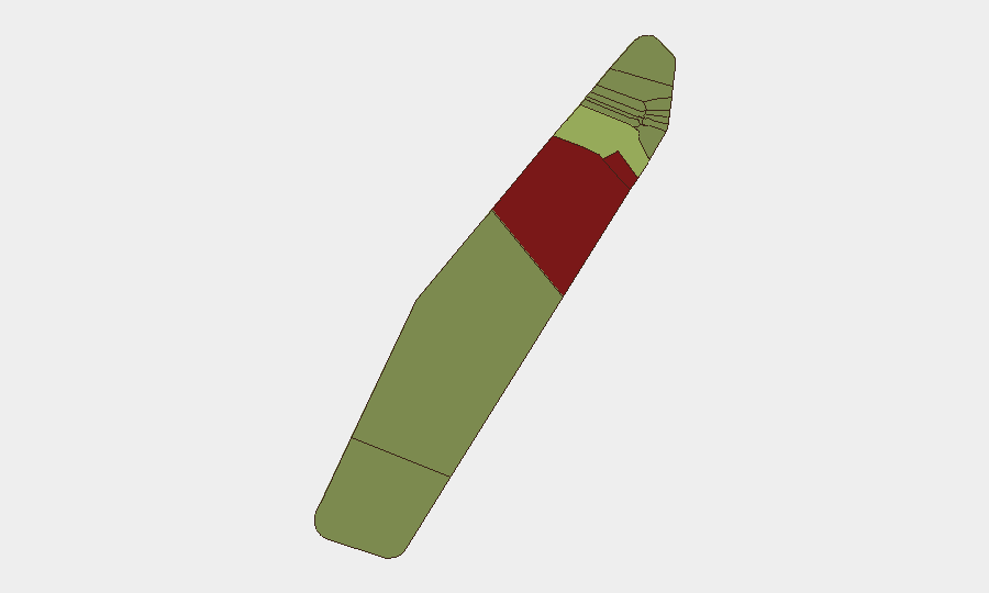
Peleliu (risk 92) and Angaur (risk 88) dominate the sub-national risk ranking and warrant continued monitoring, though neither has generated tracked incidents in the current assessment window. Both states carry elevated composite scores reflecting historical conflict footprints, infrastructure limitations, limited local security capacity, and demographic factors rather than active destabilization. Koror (risk 45), the commercial and population center, registers moderate risk consistent with its role as the primary economic and diplomatic hub; Melekeok (risk 35) and Airai (risk 32) show lower but non-negligible exposure. The remaining states (Ngatpang through Ngchesar) fall into a lower-risk band (22–28) and reflect routine sub-national patterns. Corporate and duty-of-care teams with assets or personnel in Peleliu and Angaur should maintain elevated baseline vigilance and contingency planning; Koror operations benefit from higher baseline security infrastructure and international presence.
How GeoBit Would Assist
Security teams managing personnel or assets in Palau would deploy AOI Monitoring & Early Warning on Peleliu, Angaur, and Koror to detect emerging civil unrest, infrastructure disruption, or conflict signals in near-real time. OSINT fusion—combining web and social media intelligence, regional news feeds, and multi-language search—provides corroborated situational awareness across the archipelago with minimal false-positive noise. Routing & Network Analysis enables rapid alternative-route and evacuation-journey planning should conditions in any state deteriorate, and GIS & Spatial Analysis supports risk-stratified asset positioning and duty-of-care decision-making. These capabilities collectively reduce detection lag and support proactive rather than reactive security posture.
7-Day Outlook
Palau's security environment is expected to remain stable over the next seven days absent unexpected external shocks (e.g., regional maritime incident, major natural disaster, or significant political crisis). Routine governance, economic, and multilateral activity will continue. Security teams should maintain standard vigilance protocols while recognizing the current low-incident trajectory and focus longer-term planning on the identified sub-national risk zones rather than acute crisis management.
Highest-Risk Areas — Ranked
| # | State / Region | Risk |
|---|---|---|
| 1 | Peleliu | 92 |
| 2 | Angaur | 88 |
| 3 | Koror | 45 |
| 4 | Melekeok | 35 |
| 5 | Airai | 32 |
| 6 | Ngatpang | 28 |
| 7 | Ngeremlengui | 26 |
| 8 | Ngaraard | 25 |
| 9 | Ngardmau | 24 |
| 10 | Aimeliik | 23 |
| 11 | Ngiwal | 22 |
| 12 | Ngchesar | 21 |
Sources
Previous Daily Briefs
A new Palau brief is written every day — each with its own risk map and downloadable CSV. Here's the last week; use the calendar to go further back.
📅 Browse every day by calendar →
Highlighted days have a brief. Tap a day for that day's map & analysis, or “csv” for that day's dataset ($5).
Atlas — our AI intelligence desk — emails them this snapshot personally. Nothing else, no list.