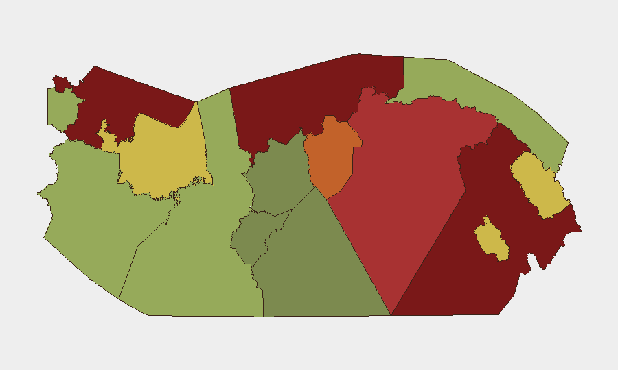
Situation Summary
Panama faces persistent baseline security challenges driven by organized crime, drug trafficking, and gang activity, particularly concentrated in remote border and Caribbean coastal zones. Law enforcement maintained operational tempo over the 2026-08-02 to 2026-08-03 weekend with 652 apprehensions and multiple firearms seizures, indicating continued police response capacity. Infrastructure vulnerabilities—including flood damage and bridge safety concerns—are compounding security risks in already-fragile regions. The threat environment remains localized to specific high-risk provinces rather than systemic nationwide; however, transnational criminal networks continue to exploit the country's geography and transit corridors.
Key Developments
- Tocumen, Panama City (2026-08-02/03) — National Police conducted a residential raid yielding firearms, ammunition, and suspected narcotics; one suspect was detained and handed to prosecutors, reflecting ongoing enforcement in the capital's periphery.
- Morrillo Beach, Mariato, Veraguas (2026-08-02/03) — Authorities seized 45 packages of suspected narcotics in a coastal operation, underscoring continued trafficking activity on Pacific beaches despite interdiction efforts.
- Changuinola, Bocas del Toro (2026-08-02/03) — Ministry of Public Works responded to damage on production roads in La Platanera, indicating either weather or criminal infrastructure disruption in this Caribbean high-risk zone.
- Oajaca Abajo (2026-08-02/03) — Public Works inspected a suspension bridge for structural safety following reported damage, raising concern about critical infrastructure resilience in remote areas.
- Nationwide Weekend Operations (ending 2026-08-03) — Police reported 652 apprehensions, multiple firearm seizures, and cash confiscation during weekend enforcement; two road fatalities occurred in Panama and Colón provinces during the period.
- Panama & Colón Provinces (2026-08-02/03) — Two traffic-related fatalities during weekend enforcement operations highlight secondary safety risks beyond organized crime.
Highest-Risk Areas
Darién (risk 95) and Colón (risk 88) remain the primary threat epicenters, driven by their proximity to Colombia, dense jungle terrain that enables drug production and smuggling networks, and minimal state presence. Bocas del Toro (risk 82) compounds Caribbean vulnerability with coastal trafficking routes and indigenous territory complications. Panamá Province (risk 78) and Panamá Oeste (risk 75) elevate risk through proximity to the Canal Zone and metropolitan infrastructure—critical for both economic targets and criminal logistics. Indigenous autonomous regions (Ngäbe-Buglé, Emberá-Wounaan, Guna Yala) rank moderately but remain exploited as trafficking corridors and gang recruitment zones. The disparity between the capital's relatively lower risk and the hinterland's acute vulnerability reflects Panama's dual-geography threat model: concentrated transnational crime in remote zones, localized enforcement and gang activity in urban centers.
How GeoBit Would Assist
Security teams should deploy AOI Monitoring & Early Warning on Darién, Colón, and Bocas del Toro with persistent satellite and OSINT watch to detect cartel camp movements, trafficking routes, and enforcement gaps before incidents escalate. Network & Actor Analysis combined with Entity Extraction across local news, police statements, and social signals can map criminal organization structure, arrest patterns, and suspected cartel affiliations in real time. GIS & Spatial Analysis layered with Routing & Network Analysis enables alternative journey planning and asset-movement optimization to avoid high-risk corridors and identify safe transit windows for personnel and supply chains.
7-Day Outlook
Enforcement operations are expected to continue at current tempo, with police weekend sweeps becoming routine; however, sustained arrests alone will not degrade cartel supply chains without interdiction at source or border. Weather-related infrastructure damage (flooding signals noted) may compound security risk by reducing state mobility and creating ungoverned space. Elevated vigilance is warranted in Bocas del Toro and Veraguas coastal zones ahead of the weekend.
Highest-Risk Areas — Ranked
| # | State / Region | Risk |
|---|---|---|
| 1 | Darién | 95 |
| 2 | Colón | 88 |
| 3 | Bocas del Toro | 82 |
| 4 | Panamá Province | 78 |
| 5 | Panamá Oeste | 75 |
| 6 | Ngäbe-Buglé | 68 |
| 7 | Emberá-Wounaan | 62 |
| 8 | Veraguas | 58 |
| 9 | Chiriquí | 48 |
| 10 | Naso Tjër Di | 45 |
| 11 | Guna Yala | 42 |
| 12 | Coclé | 35 |
Sources
Previous Daily Briefs
A new Panama brief is written every day — each with its own risk map and downloadable CSV. Here's the last week; use the calendar to go further back.
📅 Browse every day by calendar →
Highlighted days have a brief. Tap a day for that day's map & analysis, or “csv” for that day's dataset ($5).
Atlas — our AI intelligence desk — emails them this snapshot personally. Nothing else, no list.