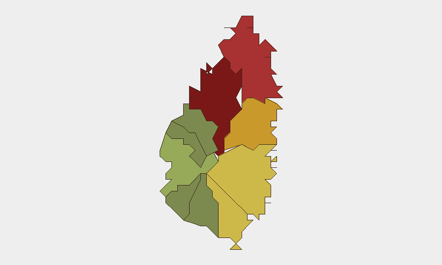
Situation Summary
Saint Lucia remains a low-tier global security concern (rank #146, composite threat score 6) but faces concentrated, localized risks in its northern urban and commercial zones. Over the past 48 hours, police have conducted coordinated firearms and drug operations, a serious pedestrian collision has occurred in Gros Islet, and marine search-and-rescue activity has been logged. The absence of tracked discrete events in GeoBit's current window, combined with sporadic but recurring traffic and violence incidents, suggests endemic rather than acute instability—though personnel and asset concentration in high-risk districts warrants monitoring.
Key Developments
- Rodney Bay Strip, Gros Islet (2026-08-09): A 28-year-old woman was struck by a minivan during an altercation and hospitalized at Owen King EU Hospital; Police investigation ongoing.
- Northern Zone (2026-08-10): Police charged three individuals for drug and gun-related offenses following a coordinated operation, indicating active law-enforcement focus on narcotics and firearms trafficking.
- Gros Islet / Northern Zone (2026-08-09–08-10): Major firearms-and-ammunition confiscation operation conducted by Police; details on scope and recovery amounts remain limited in public reporting.
- Offshore, Near Gros Islet Waters (2026-08-09): Police Marine Unit responded to a distressed vessel, signaling maritime safety concerns and Coast Guard responsiveness in territorial waters.
- Laborie, Banse La Grace (2026-08-04, background context): A motor-vehicle collision resulted in three presumed fatalities, illustrating ongoing road-safety hazards in southern and rural districts.
- Rodney Bay & Dennery (2026-08-03–04, background context): Multiple traffic incidents over the preceding weekend hospitalized several persons, including a separate crash in Dennery; pattern consistent with seasonal or behavioral risk factors.
Highest-Risk Areas
Castries (risk 95) and Gros Islet (risk 78) dominate the sub-national threat profile, driven by their status as commercial, residential, and tourism hubs where criminal enterprise, gang activity, and street-level violence concentrate. Dennery (72) and Vieux Fort (68) follow, reflecting secondary urban density and socioeconomic strain. The northern corridor—Castries through Gros Islet—accounts for the majority of reported firearms operations, drug trafficking, and interpersonal violence; Gros Islet specifically has emerged as a flashpoint for both criminal enforcement and police response in the past 48 hours. Southern districts (Laborie, Choiseul, Anse La Raye) and rural zones show markedly lower risk, though transport-corridor incidents (e.g., Laborie crash) confirm that road-safety hazards and opportunistic crime remain present.
How GeoBit Would Assist
Security teams with personnel or assets in Saint Lucia should deploy AOI Monitoring & Early Warning on Castries and Gros Islet to detect emerging violence clusters and police/enforcement activity in real time. Intel Sweep and multi-language OSINT fusion (including X/Twitter and local news streams) enable continuous asset-protection teams to track gang communication, drug-market shifts, and maritime smuggling patterns. Risk & Threat Assessment and Routing & Network Analysis tools allow duty-of-care managers to plan alternative transport routes around high-risk districts and identify safe windows for staff movement.
7-Day Outlook
Police interdiction activity and firearms seizures suggest sustained enforcement pressure on narcotics and weapons trafficking, likely to continue through the week. Road-safety incidents and street-level altercations are expected to remain sporadic but recurring; no major escalation or organized event-driven risk is anticipated. Personnel movement into or through Castries and Gros Islet should remain contingent on time-of-day, group size, and real-time operational intelligence.
Highest-Risk Areas — Ranked
| # | State / Region | Risk |
|---|---|---|
| 1 | Castries | 95 |
| 2 | Gros Islet | 78 |
| 3 | Dennery | 72 |
| 4 | Vieux Fort | 68 |
| 5 | Micoud | 65 |
| 6 | Soufrière | 42 |
| 7 | Laborie | 38 |
| 8 | Choiseul | 35 |
| 9 | Anse La Raye | 28 |
| 10 | Canaries | 12 |
Sources
Previous Daily Briefs
A new Saint Lucia brief is written every day — each with its own risk map and downloadable CSV. Here's the last week; use the calendar to go further back.
📅 Browse every day by calendar →
Highlighted days have a brief. Tap a day for that day's map & analysis, or “csv” for that day's dataset ($5).
Atlas — our AI intelligence desk — emails them this snapshot personally. Nothing else, no list.