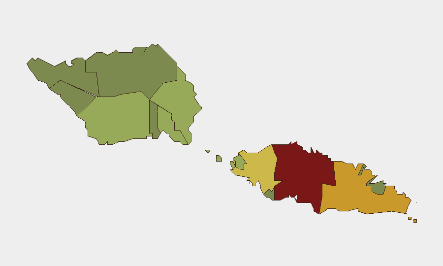
Situation Summary
Samoa maintains a composite global threat ranking of #88 with no tracked discrete security events in the past week. The security environment remains characterized by underlying vulnerabilities in maritime governance and isolated incidents of press restriction rather than acute, widespread instability. The overall threat trajectory is stable, though localized governance and transnational crime pressures warrant continued monitoring.
Key Developments
- Apia, September 29–October 2: Police Remembrance Day event at the Government Building resulted in a press incident in which the Prime Minister's security detail confiscated a camera belonging to a *Samoa Observer* reporter and deleted photographs. The Journalists Association of Samoa called for an investigation; the government defended its existing ban on the *Samoa Observer* while claiming restrictions on other independent media remain absent. (Tuamasaga district)
- Maritime domain, September 29: Foreign Minister Fiamē Naomi Mataʻafa warned at a UN forum that transnational criminal networks are actively exploiting Samoa's maritime area for illegal trafficking, including illicit drugs. This represents an official acknowledgment of an ongoing structural threat rather than a discrete recent seizure or interdiction.
- Samoa coastal and marine waters, October 3: The Samoa Meteorology Division maintained a marine severe-weather advisory through Monday, with wave heights forecast to reach 3 metres and hazardous sea conditions. Fishermen and maritime travelers were advised to monitor official updates. (Nationwide maritime impact)
- Maota Airport, Savai'i, October 8 (forthcoming): The Samoa Airport Authority confirmed that domestic flight services between Upolu and Maota are scheduled to resume on October 8, with two daily flights on Mondays, Wednesdays, and Fridays, following completion of renovation work. (Savai'i; operational/logistics development)
Highest-Risk Areas
Tuamasaga district (risk score 85) and Ātua district (risk score 71) drive the majority of composite risk in Samoa, reflecting concentration of government infrastructure, administrative functions, and urban activity in Upolu's capital region. Press-governance friction and urban crime patterns contribute to Tuamasaga's elevated profile. Mid-tier districts (Aʻana, Aiga-i-le-Tai, Faʻasaleleaga) carry moderate baseline risk, while outer districts show substantially lower scores, reflecting lower population density and administrative activity. Maritime and transnational crime pressures affect the entire nation regardless of sub-national ranking.
How GeoBit Would Assist
Security teams monitoring Samoa should employ OSINT fusion and corroboration (X/Twitter, Telegram, local news feeds) to detect early signs of press restrictions, civil unrest, or governance friction in Tuamasaga and Ātua. Maritime and aviation tracking combined with AOI monitoring and early warning on key ports and airports will provide persistent visibility into transnational crime flows and trafficking patterns flagged by the Foreign Ministry. Sentiment and temporal analysis of local media and government statements supports rapid detection of escalation in governance or stability narratives.
7-Day Outlook
No acute security events are forecast for the coming week. The scheduled resumption of domestic flights to Savai'i on October 8 should proceed as planned, barring weather or mechanical delays. Continued monitoring of maritime crime indicators and press-governance relations is advisable to detect any pattern shift in either domain.
Highest-Risk Areas — Ranked
| # | State / Region | Risk |
|---|---|---|
| 1 | Tuamasaga | 85 |
| 2 | Ātua | 71 |
| 3 | Aʻana | 62 |
| 4 | Aiga-i-le-Tai | 55 |
| 5 | Faʻasaleleaga | 48 |
| 6 | Palauli | 42 |
| 7 | Satupaʻitea | 38 |
| 8 | Gagaʻemauga | 35 |
| 9 | Gagaʻifomauga | 32 |
| 10 | Vaisigano | 28 |
| 11 | Vaʻa-o-Fonoti | 23 |
Sources
Previous Weekly Briefs
A new Samoa brief is written every Monday, covering the week — each with its own risk map and downloadable CSV. Use the calendar to go further back.
- September 28, 2026
- September 21, 2026
- September 14, 2026
- September 7, 2026
- September 2, 2026
- August 31, 2026
- August 29, 2026
📅 Browse past briefs by calendar →
Highlighted days have a brief. Tap a day for that day's map & analysis, or “csv” for that day's dataset ($5).
Atlas — our AI intelligence desk — emails them this snapshot personally. Nothing else, no list.