Situation Summary
Saudi Arabia faces an acute escalation in missile and drone attacks targeting energy and transport infrastructure, primarily from Yemen-based Houthi forces responding to Saudi-led coalition strikes. The attacks on 25 July—including strikes on Aramco facilities, airports, and the Petroline pipeline—represent an expansion in both scale and targeting of critical national infrastructure. The Cabinet's 24–25 July condemnation of Iran-backed militia activity signals official concern over sustained threats to oil exports, maritime commerce, and regional stability. Risk trajectory remains elevated, with Riyadh Region and Western coastal provinces now primary focus areas.
Key Developments
- Yanbu Governorate, Western Saudi Arabia – Saturday, 25 July 2026
Saudi Civil Defense issued three consecutive early-warning alerts for "potential danger" in Yanbu via the National Early Warning Platform; alerts were subsequently lifted with authorities reporting no casualties or damage, though multiple sources linked warnings to Houthi missile activity targeting Saudi Aramco facilities and Yanbu airport, resulting in temporary suspension of airport operations.
- Jazan Province, Southwestern Saudi Arabia – Saturday, 25 July 2026
Parallel civil defense alert issued and subsequently lifted; no casualties or damage reported. Alert timing coincided with reports of Yemeni missile attacks on regional airport and energy infrastructure in the same province.
- Jizan Aramco Refinery – Saturday, 25 July 2026
Houthi-linked sources claim missile strike on Aramco refinery facility; AFP-verified video evidence shows dark smoke rising from the site, consistent with damage to crude processing or storage infrastructure.
- Petroline Pipeline / Yanbu Port – Saturday, 25 July 2026
Reporting indicates Houthi drones targeted the Petroline pipeline terminating at Yanbu port, marking an expansion in targeting patterns from military/airport infrastructure to crude export routes on the Red Sea.
- Saudi-Led Coalition Response – Friday–Saturday, 24–25 July 2026
Coalition reported strikes on Houthi military sites in Hodeidah Province and Kamaran Island, Yemen, described as response to recent attacks on commercial vessels in Red Sea waters; Yemeni sources confirmed hits on naval base and military camp.
- Cabinet Statement – Tuesday, 24–25 July 2026
Saudi Cabinet publicly condemned attacks by Iran-backed militias in Yemen and Iraq on oil facilities in Riyadh Region and Eastern Province, and on Red Sea commercial shipping; pledged decisive responses and signaled sustained concern over energy security.
Highest-Risk Areas
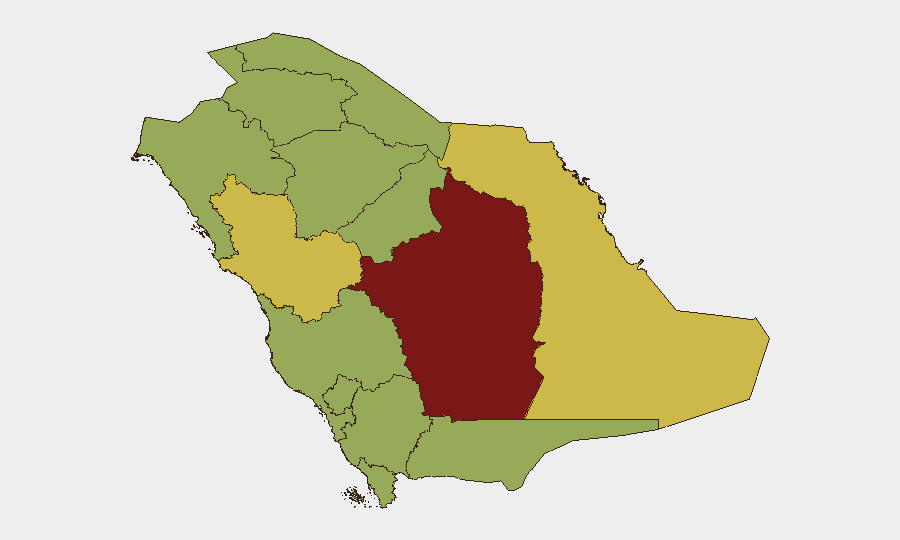
Riyadh Region (82.3) remains the country's highest-risk area, reflecting both national capital concentration and recent direct Cabinet acknowledgment of attacks on oil facilities there. Medina Province (66) and Eastern Province (61.8) follow, with the latter particularly vulnerable due to concentration of downstream refining and petrochemical assets; both regions have experienced Houthi targeting since at least February 2026. Western coastal zones (Yanbu in Makkah Region, Jazan, Asir) carry elevated risk due to Aramco infrastructure density and Red Sea exposure; the Petroline pipeline termination at Yanbu now represents a demonstrated target set.
How GeoBit Would Assist
Security teams should deploy AOI Monitoring & Early Warning on Riyadh energy complexes, Yanbu and Jazan airports, and Petroline infrastructure to detect pre-attack indicators and civil defense alerts in real time. Conflict & Military tracking (force structure, weapons-capability assessment) and Maritime & Aviation tracking would provide early visibility of Houthi launch activity in Yemen and coalition response timings. OSINT fusion (Twitter, Telegram, regional media) corroborated with Satellite & Imagery analysis accelerates damage assessment and threat confirmation independent of official announcements.
7-Day Outlook
Escalation dynamics suggest continued Houthi strike activity in response to ongoing coalition operations; attacks will likely cycle between energy infrastructure, airports, and maritime targets in Red Sea approaches. No de-escalation signals are evident. Security teams should expect further civil defense alerts, temporary transport/port disruptions, and potential supply-chain impacts to energy exports within the next 7 days.
Highest-Risk Areas — Ranked
| # | State / Region | Risk |
|---|---|---|
| 1 | Riyadh Region | 82.3 |
| 2 | Medina Province | 66 |
| 3 | Eastern Province | 61.8 |
| 4 | Jazan Province | 59.6 |
| 5 | 'Asir Province | 52.5 |
| 6 | Northern Borders Province | 52.3 |
| 7 | Makkah Region | 52.3 |
| 8 | Al-Bahah Province | 52.3 |
| 9 | Najran Region | 52.3 |
| 10 | Tabuk Province | 52.3 |
| 11 | Al Jawf Region | 52.3 |
| 12 | Ḥa'il Province | 52.3 |
Sources
Previous Daily Briefs
A new Saudi Arabia brief is written every day — each with its own risk map and downloadable CSV. Here's the last week; use the calendar to go further back.
📅 Browse every day by calendar →
Highlighted days have a brief. Tap a day for that day's map & analysis, or “csv” for that day's dataset ($5).
Atlas — our AI intelligence desk — emails them this snapshot personally. Nothing else, no list.