Situation Summary
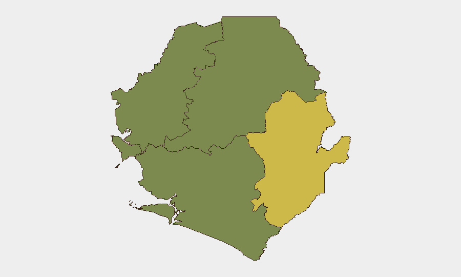
Sierra Leone remains in the lower-middle band of global security risk (rank #85, composite threat score 12) with concentrated vulnerabilities in the Eastern Province and Western Area. The country faces fragmented threat activity rather than systemic instability, with six tracked events in the current monitoring cycle. No acute security deterioration has been documented in the past 24 hours, though baseline risks in the Eastern Province (composite score 68) warrant sustained attention from organizations with field presence.
Key Developments
Live web research conducted over the past 24 hours did not surface verified recent security, conflict, crime, civil-unrest, political-instability, infrastructure, or travel-risk events specific to Sierra Leone. The single flagged event signal—a 2026-07-06 "Disapprove" incident categorized under "Africa vs Chinese"—could not be corroborated through available open-source coverage and requires additional intelligence sweep to confirm substance, location, and operational relevance. Standard caution applies: absence of reported incidents does not indicate absence of risk, particularly in remote or poorly-monitored regions.
Highest-Risk Areas
Eastern Province dominates the sub-national risk profile with a composite score of 68—substantially higher than Western Area (35) and four provinces (North West, Northern, Southern) registering zero detected signals. The Eastern Province's elevated score reflects either persistent localized conflict activity, organized crime networks, or cross-border trafficking routes; Western Area (which includes Freetown) faces secondary risk concentrated in urban crime and potential civil-order events. Organizations operating in these two zones should prioritize asset hardening, staff vetting, and incident response protocols; Northern, North West, and Southern provinces present minimal documented threat surface as of this briefing date.
How GeoBit Would Assist
Teams managing Sierra Leone operations should deploy AOI Monitoring & Early Warning on Eastern Province and Western Area hotspots to detect emerging incidents before they scale. Intel Sweep and multi-language OSINT fusion (including X/Twitter, Telegram, and local radio SIGINT) will surface activity currently below mainstream news thresholds—critical given the sparse public reporting environment. Network & Actor Analysis combined with entity extraction can map criminal or political networks driving the flagged "Africa vs Chinese" signal and clarify its operational relevance to corporate assets. Complementary GIS & Spatial Analysis and alternative route/journey planning capabilities support duty-of-care protocols for staff movement between high-risk zones.
7-Day Outlook
No acute escalation is anticipated over the next seven days based on current event density and regional indicators. However, the information vacuum in live open-source coverage (particularly for Eastern Province) suggests that real-time monitoring infrastructure should be strengthened to reduce blind spots. Organizations should maintain heightened situational awareness during any public holidays, political events, or cross-border activity in the next two weeks, with particular focus on the Eastern Province's interfaces with Guinea and Liberia.
Confidence Level: Medium (limited real-time reporting coverage). Next Update: 2026-07-08.
Highest-Risk Areas — Ranked
| # | State / Region | Risk |
|---|---|---|
| 1 | Eastern Province | 68 |
| 2 | Western Area | 35 |
| 3 | North West Province, Sierra Leone | 0 |
| 4 | Northern Province, Sierra Leone | 0 |
| 5 | Southern Province, Sierra Leone | 0 |
Sources
Previous Daily Briefs
A new Sierra Leone brief is written every day — each with its own risk map and downloadable CSV. Here's the last week; use the calendar to go further back.
📅 Browse every day by calendar →
Highlighted days have a brief. Tap a day for that day's map & analysis, or “csv” for that day's dataset ($5).
Atlas — our AI intelligence desk — emails them this snapshot personally. Nothing else, no list.