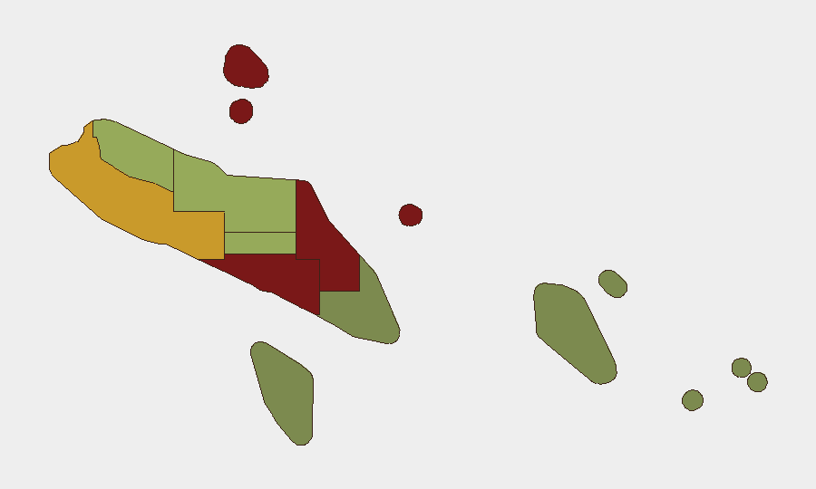
Situation Summary
Solomon Islands remains a stable, low-threat environment at the national level (global rank #139, composite score 7), with no acute security incidents, civil unrest, or infrastructure disruptions reported in the last 24–48 hours. The country's security posture is shaped by ongoing geopolitical repositioning—specifically, diplomatic engagement with the U.S. and Australia alongside review of existing security partnerships—rather than by domestic instability or criminal escalation. Risk remains concentrated in Honiara and Guadalcanal, driven by urban crime and social tensions; provincial areas are substantially lower-risk.
Key Developments
- Honiara, 10 Aug 2026: Prime Minister Matthew Wale announced a government review of Solomon Islands' 2022 security agreement with China, pledging increased transparency in future security arrangements. This reflects diplomatic repositioning but does not indicate an acute security incident or domestic disruption.
- Honiara, 10 Aug 2026: The Wale government characterized the recently signed U.S.–Solomon Islands maritime law-enforcement shiprider agreement as a sovereignty-preserving measure, positioning it as consistent with "friends to all and enemy to none" foreign policy. Opposition and civil society criticism has been noted; no civil disorder has been reported.
- Nationwide, 7 Aug 2026: Reuters reporting confirmed Solomon Islands is actively repairing diplomatic ties with the U.S. and Australia while maintaining its independent foreign policy stance. This represents routine diplomatic engagement rather than a security emergency.
- Nationwide, 6 Aug 2026: Royal Solomon Islands Police Force (RSIPF) drone specialists were selected for regional security deployment to Palau. This is a routine force-generation activity with no domestic security implications.
- No acute incidents recorded, 24–48 hour window: Web research and event monitoring returned no verified reports of acute crime, protests, clashes, infrastructure failures, or travel disruptions in Solomon Islands during 10–12 August 2026.
Highest-Risk Areas
Honiara (risk 92) and Guadalcanal (risk 88) dominate the sub-national risk profile, reflecting urban concentration of petty crime, gang activity, and occasional civil disorder in the capital and surrounding province. Malaita (risk 85) and Western Province (risk 72) also warrant monitoring, though incidents remain sporadic. Outer provinces—Temotu, Rennell and Bellona, and Makira-Ulawa—present substantially lower risk. For corporate personnel and assets, Honiara remains the priority focus area; travel to and within the capital should follow standard urban-crime precautions, while provincial deployments face lower but non-zero community-relations and petty-crime risks.
How GeoBit Would Assist
Security teams operating in Solomon Islands should deploy AOI (Area-of-Interest) Monitoring & Early Warning on Honiara and Guadalcanal to detect emerging crime clusters, civil unrest, or infrastructure disruptions in real time. Intel Sweep and global event feeds, combined with X/Twitter and Telegram OSINT, provide 24/7 monitoring of security developments, diplomatic incidents, and social sentiment. Risk & Threat Assessment and Network & Actor Analysis support ongoing review of geopolitical shifts (U.S.–China–Australia competition, security agreements) that may affect operating environment, permits, or duty-of-care obligations for in-country teams.
7-Day Outlook
No significant escalation in acute threats is expected over the next seven days. Diplomatic activity around security agreements will likely continue at the government level, but this poses minimal operational risk to corporate personnel. Standard urban-crime vigilance in Honiara remains the primary mitigating measure; no travel restrictions are warranted at this time.
Highest-Risk Areas — Ranked
| # | State / Region | Risk |
|---|---|---|
| 1 | Honiara | 92 |
| 2 | Guadalcanal | 88 |
| 3 | Malaita | 85 |
| 4 | Western | 72 |
| 5 | Choiseul | 58 |
| 6 | Isabel | 52 |
| 7 | Central Province | 48 |
| 8 | Makira-Ulawa | 38 |
| 9 | Rennell and Bellona | 22 |
| 10 | Temotu | 18 |
Sources
Previous Daily Briefs
A new Solomon Islands brief is written every day — each with its own risk map and downloadable CSV. Here's the last week; use the calendar to go further back.
📅 Browse every day by calendar →
Highlighted days have a brief. Tap a day for that day's map & analysis, or “csv” for that day's dataset ($5).
Atlas — our AI intelligence desk — emails them this snapshot personally. Nothing else, no list.