Situation Summary
Suriname presents a stable, low-acute-threat environment as of 31 July 2026, with no verified security incidents, civil unrest, or infrastructure disruptions reported in the past 48 hours. The national composite threat score remains at 4, reflecting endemic challenges (interior organized crime, trafficking, mining-related violence) rather than active, escalating crises. Risk remains geographically concentrated in the remote interior and select urban zones; the broader security trajectory is one of chronic, managed risk rather than deterioration.
Key Developments
No verified security, crime, civil-unrest, infrastructure, or travel-risk incidents have been confirmed for Suriname in the 24–48 hour period ending 31 July 2026. Open-source news feeds, mainstream outlets, and commercial security monitoring show no time-stamped incidents for 30–31 July. The most recent corroborated law-enforcement events in available databases are dated 2–3 July 2026. Absence of incident reporting does not indicate absence of risk; rather, it reflects a period of operational quiet relative to typical baseline activity in Paramaribo and the interior. Teams should note that this reporting vacuum is consistent with low-intensity but persistent underlying conditions (informal economy crime, trafficking networks, artisanal/illegal mining operations) that do not always generate immediate public incident logs.
Highest-Risk Areas
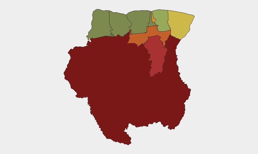
Sipaliwini (risk 92) dominates the threat landscape; this remote, sparsely administered southern interior region hosts illegal gold mining, drug-trafficking infrastructure, and limited state presence, creating persistent vulnerability to criminal exploitation and violence. Brokopondo (78), Para (74), and Paramaribo (71) form a secondary cluster driven by urban crime (robbery, assault, gang activity), drug markets, and trafficking transit corridors. Marowijne (68), the eastern border zone with French Guiana, carries elevated risk owing to cross-border smuggling networks and porous enforcement. Mid-tier districts (Commewijne, Wanica, Saramacca) show moderate risk tied to localized crime and informal settlements; western and northern zones (Coronie, Nickerie) remain comparatively lower-risk.
How GeoBit Would Assist
Security teams managing personnel or assets in Suriname should deploy AOI Monitoring & Early Warning on high-risk districts (Sipaliwini, Brokopondo, Paramaribo) to detect emerging crime clusters, trafficking activity, or violence spikes. Multi-language OSINT and sentiment analysis of Surinamese news, social media (X, Telegram), and local radio feeds enable early detection of political statements, labor unrest, or public grievances before they escalate. Network & Actor Analysis paired with entity extraction helps map criminal and trafficking networks operating in the interior and border zones, informing route-planning and personnel-movement decisions.
7-Day Outlook
No acute incidents or policy shifts are forecast for the immediate week. Risk trajectory remains static, with endemic challenges (trafficking, informal mining, localized urban crime) persisting at baseline. Security teams should maintain routine monitoring posture and update travel and movement protocols if personnel are scheduled for interior or Sipaliwini transit, where infrastructure and communication are limited and state presence is minimal.
Highest-Risk Areas — Ranked
| # | State / Region | Risk |
|---|---|---|
| 1 | Sipaliwini | 92 |
| 2 | Brokopondo | 78 |
| 3 | Para | 74 |
| 4 | Paramaribo | 71 |
| 5 | Marowijne | 68 |
| 6 | Commewijne | 42 |
| 7 | Wanica | 38 |
| 8 | Saramacca | 29 |
| 9 | Coronie | 12 |
| 10 | Nickerie | 8 |
Sources
- geobit.ai
- data.humdata.org
- surinamenieuwscentrale.com
- surinamenieuwscentrale.com
- surinamenieuwscentrale.com
- srnieuws.com
- waterkant.net
- surinamenieuwscentrale.com
- surinamesuntimes.com
- surinamenieuwscentrale.com
- newsdata.io
- surinametimes.com
- sun.sr
- surinamenieuwscentrale.com
- surinamenieuwscentrale.com
- srnieuws.com
- srnieuws.com
- surinametimes.com
Previous Daily Briefs
A new Suriname brief is written every day — each with its own risk map and downloadable CSV. Here's the last week; use the calendar to go further back.
📅 Browse every day by calendar →
Highlighted days have a brief. Tap a day for that day's map & analysis, or “csv” for that day's dataset ($5).
Atlas — our AI intelligence desk — emails them this snapshot personally. Nothing else, no list.