Situation Summary
Turkmenistan's security environment remains publicly calm and stable, with no verified incidents reported in the last 24–48 hours. The country maintains tight state control over information and a generally low crime baseline, though petty crime, smuggling in border regions, and strict legal constraints on movement and communications persist as ongoing background risks. The subnational threat picture is heavily concentrated in the northwestern border zones, while the capital and southern regions present materially lower risk profiles.
Key Developments
- No verified new security incidents reported in Turkmenistan during July 12–13, 2026. Official government media, international travel advisories, and accessible open-source reporting contain no timestamped incident reports, civil unrest, infrastructure disruptions, or acute crime events for this period.
- Border control environment (nationwide, ongoing): Serhetabat and Imam-Nazar border crossings remain open in principle but require difficult-to-obtain prior approval, reflecting persistent tight border administration rather than a recent policy shift.
- Legal and technical environment (Ashgabat, standing): VPN prohibition, strict currency-exchange controls, and criminalization of certain conduct remain in force and shape operational constraints for international personnel and business activity.
- Terrorism threat (nationwide, general): German Foreign Office notes a global baseline risk of terrorist attacks and kidnappings involving groups such as Al-Qaida and IS, but does not cite specific plots or recent activity targeting Turkmenistan itself.
Highest-Risk Areas
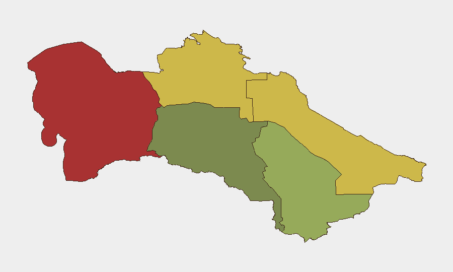
The Balkan Region (risk 78) and Lebap Region (risk 68) dominate Turkmenistan's subnational threat landscape, driven by proximity to the Afghan and Iranian borders and associated smuggling, trafficking, and cross-border security activity. Dashoguz Region (risk 62) presents elevated risk for similar reasons. By contrast, Ashgabat City (risk 18) and Ahal Region (risk 35) carry substantially lower composite scores, reflecting tighter state presence, lower trafficking volumes, and reduced cross-border exposure in the capital and southern territories. Organizations with personnel or assets in the north should prioritize border-zone monitoring and restrict movement near Serhetabat and other crossing points.
How GeoBit Would Assist
Security and risk teams can employ GeoBit's AOI Monitoring & Early Warning capability to maintain persistent watch on the Balkan and Lebap regions for cross-border activity, smuggling indicators, or civil disruption, with real-time alerting tied to specific geographic triggers. Intel Sweep and multi-language OSINT fusion across official media, social platforms, and regional networks will provide early visibility into any emerging incidents or policy changes, compensating for Turkmenistan's restricted information environment. Routing & Network Analysis supports duty-of-care planning by modeling safe transit corridors and identifying checkpoints or border-control pinch points that may affect staff movement or supply chains.
7-Day Outlook
No acute security deterioration is forecasted for the coming week. The stable, controlled environment is likely to persist, barring unexpected developments in cross-border dynamics with Afghanistan or Iran. Organizations should maintain standard protocols for border-zone operations and monitor for any shifts in Ashgabat's administrative stance on movement, visas, or foreign activity, which historically may be communicated with limited advance notice.
Highest-Risk Areas — Ranked
| # | State / Region | Risk |
|---|---|---|
| 1 | Balkan Region | 78 |
| 2 | Lebap Region | 68 |
| 3 | Dashoguz Region | 62 |
| 4 | Mary Region | 42 |
| 5 | Ahal Region | 35 |
| 6 | Ashgabat City | 18 |
Sources
Previous Daily Briefs
A new Turkmenistan brief is written every day — each with its own risk map and downloadable CSV. Here's the last week; use the calendar to go further back.
📅 Browse every day by calendar →
Highlighted days have a brief. Tap a day for that day's map & analysis, or “csv” for that day's dataset ($5).
Atlas — our AI intelligence desk — emails them this snapshot personally. Nothing else, no list.