Situation Summary
Venezuela remains under a declared state of emergency following twin major earthquakes on 24 June, with confirmed fatalities exceeding 1,719 and tens of thousands missing as of early July. Search-and-rescue operations, infrastructure disruption, and strained emergency services continue to dominate the security landscape across affected regions, compounding baseline risks from organized crime and political instability. No major new armed clashes, mass protests, or discrete political incidents have been corroborated in the last 24–48 hours; the current threat environment is primarily shaped by ongoing disaster response and persistent criminal activity operating under an expanded emergency framework.
Key Developments
- Caracas and nationwide – 3–4 July: Continued heavy search-and-rescue operations and civilian participation in recovery efforts following the 24 June earthquakes; emergency services remain overstretched, with congested routes and intermittent utilities elevating operational friction and safety risk for corporate movement and logistics.
- Multiple affected regions (coastal and urban zones) – 3–4 July: Humanitarian organizations are scaling deployment of emergency medical teams and aid operations into Venezuela to support damaged health systems; this reflects ongoing crisis conditions, including potential for localized disorder and resource competition.
- Nationwide – state of emergency framework (in effect since 24 June, confirmed active through 3–4 July): Expanded powers for security forces and emergency authorities continue to shape movement controls, checkpoints, and curfews in some areas, directly affecting travel and operational access.
- Nationwide – baseline crime environment: UK FCDO and recent travel advisories confirm that violence and serious criminal activity—including homicide, armed robbery, kidnapping, and carjacking—remain significant and ongoing security concerns, independent of earthquake impacts.
- Event signal review (2026-07-03 to -05): GeoBit's recent event feed includes citizen territory occupation, rebel threats, arrests by authorities, and public statements by the presidency regarding international criticism; these signals reflect underlying political and social tension but have not escalated to discrete new incidents in the last 24–48 hours.
Highest-Risk Areas
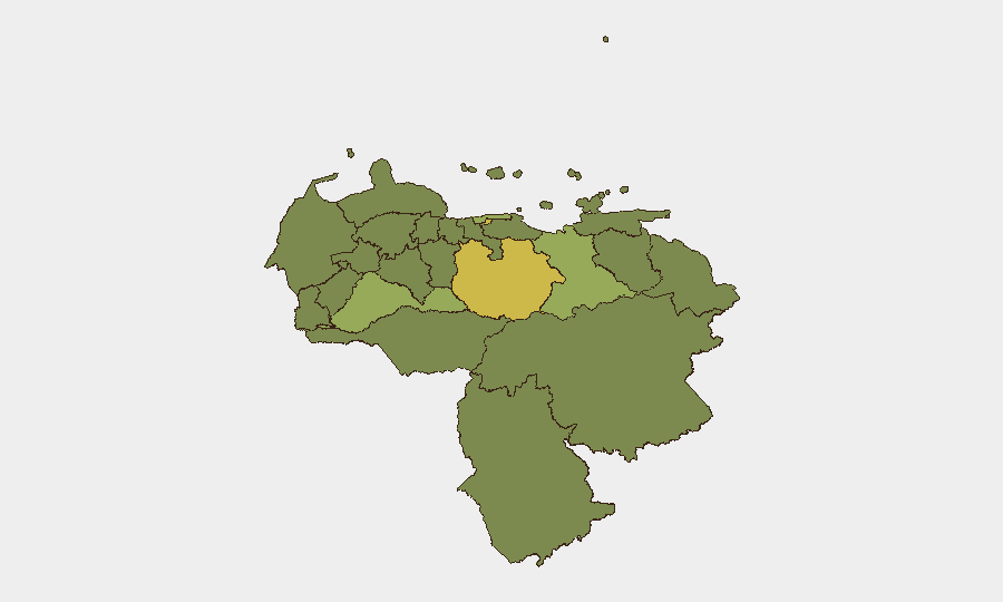
Guarico State (67.3) and the Federal District (64.4) carry the highest composite risk scores and drive vulnerability across the country. Guarico's elevated rating reflects a combination of armed-group activity, organized crime, and limited state presence; the Federal District (Caracas metropolitan area) faces compounded risk from high homicide and kidnapping rates, gang territorial control, and now earthquake-related infrastructure collapse and emergency congestion. Secondary cluster risk (Anzoategui, Barinas, Vargas, and Carabobo, all in the 38–42 range) indicates geographically dispersed crime, gang presence, and, in coastal zones, vulnerability to maritime trafficking and irregular migration networks. These rankings underscore that earthquake damage is overlaying an already fractured security environment.
How GeoBit Would Assist
Security teams operating in Venezuela should deploy Intel Sweep and OSINT fusion to track real-time rescue operations, checkpoint movements, and curfew changes affecting travel corridors, cross-referenced with multi-language X/Twitter and Telegram monitoring to detect emerging localized unrest or criminal activity during the emergency window. AOI Monitoring with alerting on Guarico State, Caracas, and secondary risk zones would provide early warning of armed clashes, mass displacement, or organized-crime escalation. Routing & Network Analysis can identify safe, operationally viable transit routes around earthquake-damaged infrastructure and active security cordons, while satellite and imagery analysis can assess real-time damage extent and checkpoint density to inform duty-of-care decisions.
7-Day Outlook
The earthquake response is expected to remain the dominant operational factor through early–mid July, with search-and-rescue intensity gradually shifting to reconstruction and aid distribution. Security force activity and government controls will likely remain elevated under the state of emergency, with continued checkpoint and curfew friction. Baseline organized-crime activity is likely to persist or increase opportunistically as emergency services remain stretched; no major political escalation is expected in the next seven days, but localized resource-driven disorder in disaster zones warrants close monitoring.
Highest-Risk Areas — Ranked
| # | State / Region | Risk |
|---|---|---|
| 1 | Guarico State | 67.3 |
| 2 | Federal District | 64.4 |
| 3 | Anzoategui State | 41.5 |
| 4 | Barinas State | 41.1 |
| 5 | Vargas State | 41.1 |
| 6 | Carabobo State | 38.6 |
| 7 | Lara State | 38.3 |
| 8 | Nueva Esparta State | 37.6 |
| 9 | Miranda State | 37.6 |
| 10 | Zulia State | 37.3 |
| 11 | Falcon State | 37.3 |
| 12 | Federal Dependencies | 37.3 |
Sources
Previous Daily Briefs
A new Venezuela brief is written every day — each with its own risk map and downloadable CSV. Here's the last week; use the calendar to go further back.
📅 Browse every day by calendar →
Highlighted days have a brief. Tap a day for that day's map & analysis, or “csv” for that day's dataset ($5).
Atlas — our AI intelligence desk — emails them this snapshot personally. Nothing else, no list.