Situation Summary
Yemen's civil war remains active and fragmented, with renewed military escalation in the western Hodeidah sector as of 10–11 July and concurrent maritime threats in the Red Sea. The composite threat score of 79 reflects persistent conventional conflict, political fragmentation, and transnational tensions (Israeli operations, US–Iran rhetoric). A UN Security Council session scheduled for Monday signals diplomatic concern and potential further hardening of positions among warring factions.
Key Developments
- Hodeidah barracks assault, 10 July (Al Hudaydah Governorate, south of city). Houthi forces launched a coordinated offensive against government-aligned army positions, reportedly killing 16 troops and wounding 22 in some of the heaviest clashes in recent months. Fighting began late Friday and continued into Saturday dawn, with government forces counterattacking to retake positions by morning.
- Southern Hodeidah front engagements, 10–11 July (western Yemen). Houthi units employed snipers, drone strikes, and mortar fire to briefly overrun multiple government positions before being pushed back, indicating renewed tactical coordination and resource availability among opposition forces.
- Red Sea merchant vessel attack, 11 July (approx. 30 nm southwest of Hodeidah). A bulk cargo ship came under small-arms fire from a skiff; onboard security returned fire and the attackers withdrew to a larger vessel with disabled AIS transponder. No casualties or serious damage reported, but attack pattern consistent with Houthi maritime threat resumption.
- Western Yemen reinforcement movements, 10–11 July (Hodeidah sector and approach roads). Both Houthi and government-aligned forces reported repositioning and moving reinforcements toward the Hodeidah axis, heightening short-term kinetic risk and travel restrictions in military zones and on key supply routes.
- UN Security Council emergency session, scheduled Monday. Diplomatic and political reporting indicates the Council has convened an open session to address escalating political and security tensions; Yemeni factions are hardening rhetorical positions via media and social channels, increasing uncertainty around the fragile truce framework.
- Houthi mobilization rhetoric and security measures, nationwide (particularly Sanaa, Saada), 11 July. Houthi authorities are reported increasing internal security deployments and local checkpoints in advance of Ashura-related events, likely to tighten movement restrictions in northern and Houthi-controlled urban areas.
Highest-Risk Areas
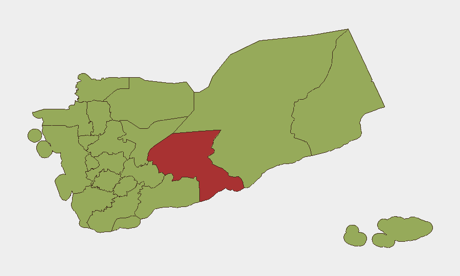
Amanat Al Asimah (Sanaa city, risk 85.4) and Shabwah Governorate (79.4) drive national risk, followed by a broad band of northern and western governorates (Sa'dah, Hajjah, Al Hudaydah, Sana'a, Raymah, Dhamar, Ibb, Ta'izz, Al Mahwit, 'Amran) all scoring 55.4. The concentration of risk in the western corridor—particularly Al Hudaydah and adjacent Ta'izz—reflects active ground combat, fragmented command structures, and maritime threats. Amanat Al Asimah's elevated score reflects political volatility, UN presence, and proxy activity.
How GeoBit Would Assist
Teams should deploy AOI Monitoring & Early Warning on Hodeidah and surrounding front lines to detect reinforcement movements and escalation signals in near real-time. Conflict & Military battle mapping and force-structure tracking enable operational assessment of Houthi and government capabilities and intentions. Maritime & Aviation tracking combined with Red Sea OSINT fusion provide early warning of renewed shipping attacks and chokepoint threats.
7-Day Outlook
Renewed Houthi offensive operations and maritime probing suggest a potential shift toward sustained escalation rather than static attrition. Political hardening ahead of the UN session and internal Houthi mobilization increase the risk of further ground combat and localized movement restrictions. Staff, supply chains, and maritime assets in the western corridor and Red Sea should anticipate elevated kinetic and operational friction through at least mid-week.
Highest-Risk Areas — Ranked
| # | State / Region | Risk |
|---|---|---|
| 1 | Amanat Al Asimah | 85.4 |
| 2 | Shabwah Governorate | 79.4 |
| 3 | Sa'dah Governorate | 55.4 |
| 4 | Hajjah Governorate | 55.4 |
| 5 | Al Mahwit Governorate | 55.4 |
| 6 | Al Hudaydah Governorate | 55.4 |
| 7 | 'Amran Governorate | 55.4 |
| 8 | Sana'a Governorate | 55.4 |
| 9 | Raymah Governorate | 55.4 |
| 10 | Dhamar Governorate | 55.4 |
| 11 | Ibb Governorate | 55.4 |
| 12 | Ta'izz Governorate | 55.4 |
Sources
Previous Daily Briefs
A new Yemen brief is written every day — each with its own risk map and downloadable CSV. Here's the last week; use the calendar to go further back.
📅 Browse every day by calendar →
Highlighted days have a brief. Tap a day for that day's map & analysis, or “csv” for that day's dataset ($5).
Atlas — our AI intelligence desk — emails them this snapshot personally. Nothing else, no list.