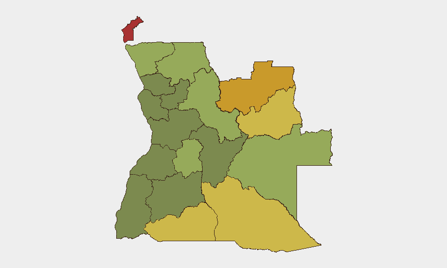
Situation Summary
Angola maintains a composite threat ranking of #48 globally with no tracked security incidents in the current reporting window. The country's risk profile is driven primarily by criminal activity, weak state capacity in remote regions, and persistent vulnerabilities in diamond-mining areas rather than by active armed conflict or organized political violence. Recent open-source reporting shows no discrete security events in the last 24–48 hours; risk assessment relies on baseline structural conditions and sub-national variation rather than event-driven alerts at present.
Key Developments
No corroborated security incidents were identified in Angola during the 24–48-hour reporting window ending 2026-07-09. Open-source and social media monitoring detected no time-stamped reports of armed conflict, civil unrest, major crime clusters, or infrastructure disruption with clear security implications. A police arrest/detention event was flagged in GeoBit feeds on 2026-07-09, but specific location, individuals, and operational context remain unconfirmed in public reporting. Multiple active wildfires have been detected across Angola (including cross-border activity with the Democratic Republic of Congo), with potential secondary effects on transportation and visibility in affected regions; a magnitude 4.4 earthquake was recorded 154 km northeast of Lucapa (Lunda Norte Province) in recent days, with no reported casualties or structural damage noted in available sources. Reporting gaps persist in remote provinces, particularly in diamond-mining zones; absence of reported incidents should not be interpreted as absence of underlying criminal or instability risk.
Highest-Risk Areas
Cabinda Province (risk 78) and the Lunda Norte and Lunda Sul provinces (72 and 68, respectively) dominate Angola's sub-national threat landscape. These three regions account for the country's most volatile dynamics: Cabinda faces historical separatist grievances and oil-sector vulnerability; the Lunda provinces are centers of artisanal diamond mining, associated with organized crime, trafficking, and informal armed groups competing for resource access. Cuando Cubango, Cunene, and Moxico provinces (64, 62, and 58) present elevated but secondary risk, primarily from cross-border trafficking and weak state presence. Central and western provinces (Huambo, Bié, Huíla) show markedly lower composite scores, reflecting better infrastructure and state capacity but persistent baseline crime and corruption.
How GeoBit Would Assist
Corporate security teams with operations or personnel in Angola should employ AOI Monitoring & Early Warning on high-risk provinces (Cabinda, Lunda Norte/Sul, Cuando Cubango) to detect emerging incidents before they affect operations. Intel Sweep and X/Twitter OSINT capabilities enable continuous scanning for non-public or emerging unrest, trafficking activity, or criminal incidents in real time, particularly in remote areas with reporting gaps. GIS & Spatial Analysis and Satellite & Imagery analysis support risk mapping of supply chains, site security posture, and environmental hazards (wildfires, seismic activity) relevant to duty-of-care obligations.
7-Day Outlook
No near-term escalation in organized political violence or armed conflict is anticipated. Baseline risks—criminal activity, informal mining operations, and state-capacity constraints in remote provinces—will persist. Wildfire activity and seismic events may create secondary operational disruptions; monitoring local environmental alerts and transport infrastructure status is advisable for teams with field operations in affected regions.
Highest-Risk Areas — Ranked
| # | State / Region | Risk |
|---|---|---|
| 1 | Cabinda Province | 78 |
| 2 | Lunda Norte Province | 72 |
| 3 | Lunda Sul Province | 68 |
| 4 | Cuando Cubango Province | 64 |
| 5 | Cunene Province | 62 |
| 6 | Moxico Province | 58 |
| 7 | Zaire Province | 54 |
| 8 | Huambo Province | 50 |
| 9 | Uíge Province | 48 |
| 10 | Malanje Province | 42 |
| 11 | Bié Province | 35 |
| 12 | Huíla Province | 32 |
Sources
Previous Daily Briefs
A new Angola brief is written every day — each with its own risk map and downloadable CSV. Here's the last week; use the calendar to go further back.
📅 Browse every day by calendar →
Highlighted days have a brief. Tap a day for that day's map & analysis, or “csv” for that day's dataset ($5).
Atlas — our AI intelligence desk — emails them this snapshot personally. Nothing else, no list.