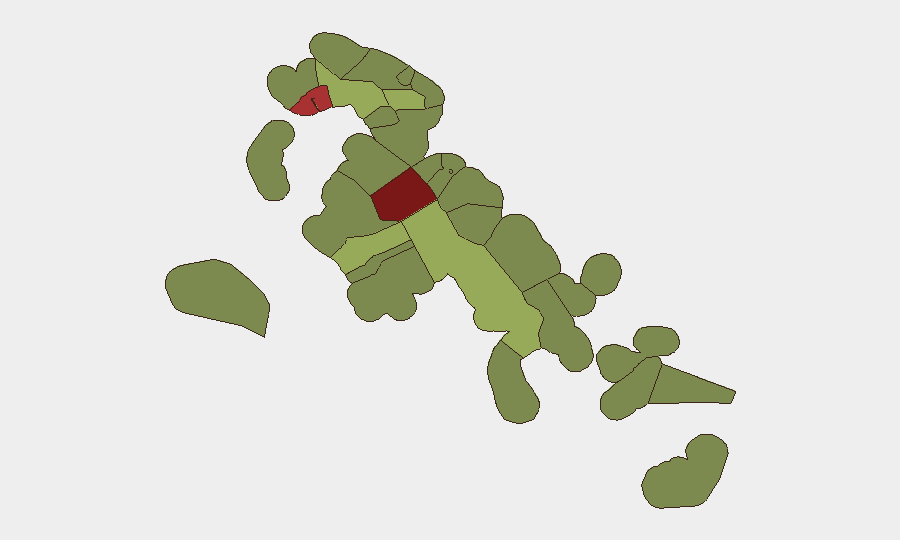
Situation Summary
The Bahamas remains a moderate-risk jurisdiction (global rank #72, composite threat score 21) with no confirmed new security incidents in the past 24–48 hours. Risk is heavily concentrated in New Providence (Nassau) and Freeport, where gang-linked street violence, property crime, and civil disorder dominate the threat landscape. The country's overall security posture reflects persistent baseline urban crime rather than acute escalation or emerging conflict.
Key Developments
- No confirmed new incidents (24–48 hour window, 2026-08-07 to 2026-08-08). Open-source monitoring and local reporting have not identified discrete security, civil-unrest, or travel-risk events in the Bahamas during this period.
- Baseline crime risk remains elevated in Nassau and Freeport. Ongoing street violence, theft, and gang activity continue to characterize New Providence and the City of Freeport, consistent with the sub-national risk ranking, but no new incident-specific alert has been generated in the current reporting window.
- Recent violent incidents (2026-08-01 to 2026-08-04, for context). Two fatal and one non-fatal shooting occurred on West Bay Street in Nassau on 4 August and 3 August; a government-led demolition of 64 structures in Blue Hills Shantytown on 1 August resulted in civil tensions and assault on task-force personnel. These events reinforce the established threat profile but do not represent new developments as of 8 August.
- Infrastructure disruptions (2026-08-01, for context). A lightning-triggered explosion at Blue Hills Power Station caused power disruptions on 1 August; restoration timeline remained unclear at time of reporting. A residential house fire on Palmetto Avenue on 3 August resulted in one fatality.
Highest-Risk Areas
New Providence (risk 92) and the City of Freeport (risk 78) account for the majority of identified threat activity and should be the primary focus of duty-of-care monitoring. Both jurisdictions experience sustained gang violence, armed robbery, and property crime. Central Abaco (52), Central Andros (48), and Exuma (45) represent secondary concern zones, where risk is significantly lower but remain above baseline. The concentration of risk in two urban centers reflects the geographic pattern of organized crime and street violence in the archipelago; outer islands and less-populated regions carry substantially reduced exposure.
How GeoBit Would Assist
Security teams with personnel or assets in the Bahamas should employ AOI Monitoring & Early Warning with persistent watch on New Providence and Freeport to detect emerging violence, civil unrest, or infrastructure disruption in real time. Intel Sweep and OSINT fusion (including X/Twitter, Telegram, and local reporting) provide continuous baseline assessment and event corroboration, critical to distinguishing genuine incident escalation from routine crime noise. Risk & Threat Assessment and Routing & Network Analysis enable rapid alternative-route planning and movement-risk mitigation if incidents occur near personnel or asset locations.
7-Day Outlook
No imminent escalation is anticipated; the security environment is expected to remain consistent with the established baseline of urban street crime concentrated in Nassau and Freeport. Continued monitoring of the Blue Hills demolition fallout and power-station recovery efforts is warranted, as civil tensions or infrastructure failures could create secondary risks to business continuity or personnel movement. Routine seasonal tropical weather and maritime hazards remain ambient risks across all island zones.
Highest-Risk Areas — Ranked
| # | State / Region | Risk |
|---|---|---|
| 1 | New Providence | 92 |
| 2 | City of Freeport | 78 |
| 3 | Central Abaco | 52 |
| 4 | Central Andros | 48 |
| 5 | Exuma | 45 |
| 6 | East Grand Bahama | 42 |
| 7 | South Andros | 38 |
| 8 | North Abaco | 35 |
| 9 | North Eleuthera | 33 |
| 10 | South Abaco | 32 |
| 11 | Cat Island | 30 |
| 12 | Mangrove Cay | 28 |
Sources
Previous Daily Briefs
A new Bahamas brief is written every day — each with its own risk map and downloadable CSV. Here's the last week; use the calendar to go further back.
📅 Browse every day by calendar →
Highlighted days have a brief. Tap a day for that day's map & analysis, or “csv” for that day's dataset ($5).
Atlas — our AI intelligence desk — emails them this snapshot personally. Nothing else, no list.