Situation Summary
Belarus remains a transit zone and secondary spillover arena amid the Russia–Ukraine conflict, with airspace incursions, infrastructure damage, and cross-border smuggling activity elevated over the past 48 hours. A major Russian drone strike on Ukraine on 22 August generated multiple airspace violations—at least 12 Banderol cruise missile-drones entered Belarusian territory, with at least one crashing deep inland after fuel exhaustion. Simultaneously, severe weather (cyclone "Priska") has disrupted power infrastructure across three regions, and localized crime incidents in Minsk have added to near-term security friction.
Key Developments
- Baranavichy airfield and Belarusian airspace, 22 August 04:00 local – At least 12 Russian Banderol hybrid missile-drones entered Belarusian airspace during a Russian strike on Ukraine, prompting emergency scramble of Belarusian Su-30 fighters from Baranavichy; one drone penetrated approximately 120 km into Belarusian territory before crashing in a field due to fuel exhaustion, raising hazards of uncontrolled debris and potential escalation miscalculation.
- Grodno Region (multiple districts), 22 August morning–afternoon – Cyclone "Priska" caused widespread power outages in over 30 settlements across Grodno, with winds forecast to 27 m/s; national operator Belenergo deployed 185 emergency repair crews across Grodno, Brest, and Vitebsk regions to address fallen trees and downed power lines affecting 148 populated areas as of 15:00 local time.
- Minsk, Prospekt Nezavisimosti 155, 21 August 17:50 – Armed robbery of a jewelry store by a suspect in medical mask claiming to possess a firearm; suspect remains at large as of 22 August per Investigative Committee and Interior Ministry reports, indicating active armed-crime risk in central commercial Minsk.
- Latvia–Belarus border, eastern Latvia, discovered by 22 August – Latvian authorities detained 28 migrants who entered Latvia via a camouflaged underground tunnel approximately 20 meters from the border; reported as the second such tunnel discovery in recent weeks, confirming organized cross-border smuggling activity and irregular migration flows linked to the Belarusian frontier.
- Krasny Kamen checkpoint and BMZ steel plant area, Minsk Region, 14–19 August (context: recent pattern) – Multiple drone strikes over one week targeted transport infrastructure; Iranian goods trucks burned and checkpoint facilities damaged, indicating sustained remote-violence risk targeting cross-border trade corridors and industrial zones.
Highest-Risk Areas
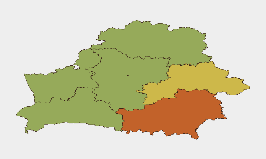
Homyel Region (risk 75) and Minsk city (risk 68) drive the sub-national risk ranking, reflecting exposure to airspace incursions, remote-violence targeting of cross-border infrastructure, and urban crime concentration. Mahilyow Region (62) follows, likely correlating with proximity to Russian border and drone-strike spillover patterns. Grodno Region's current power-infrastructure vulnerability from cyclone damage and proximity to the EU border (irregular migration tunneling) elevates operational risk for supply chains, telecommunications, and essential services. Rural and eastern regions remain most exposed to airspace debris and cross-border spillover effects.
How GeoBit Would Assist
Security teams should deploy AOI Monitoring & Early Warning on high-risk regions (Homyel, Minsk, Mahilyow) with persistent airspace and cross-border alerts; use Conflict & Military (battle mapping, weapons-capability tracking) to correlate Russian strike patterns with Belarusian airspace penetrations; and leverage Intel Sweep (global event feeds, OSINT fusion) to track cross-border smuggling routes, migration tunnels, and crime developments in real time. GIS & Spatial Analysis can model infrastructure-vulnerability zones affected by weather and drone strikes to inform asset-protection priorities.
7-Day Outlook
Russian drone strikes on Ukraine will likely continue generating airspace violations and debris-hazard risk over Belarus through early September. Cyclone "Priska" recovery operations will dominate infrastructure-repair efforts in western regions through 23–24 August, with residual outages possible in rural areas. Cross-border smuggling and crime patterns are expected to remain elevated; armed-robbery suspect apprehension in Minsk remains outstanding.
Highest-Risk Areas — Ranked
| # | State / Region | Risk |
|---|---|---|
| 1 | Homyel Region | 75 |
| 2 | Minsk | 68 |
| 3 | Mahilyow Region | 62 |
| 4 | Brest Region | 55 |
| 5 | Hrodna Region | 52 |
| 6 | Minsk Region | 48 |
| 7 | Vitsebsk Region | 45 |
Sources
Previous Daily Briefs
A new Belarus brief is written every day — each with its own risk map and downloadable CSV. Here's the last week; use the calendar to go further back.
- August 20, 2026
- August 18, 2026
- August 15, 2026
- August 13, 2026
- August 11, 2026
- August 10, 2026
- August 8, 2026
📅 Browse every day by calendar →
Highlighted days have a brief. Tap a day for that day's map & analysis, or “csv” for that day's dataset ($5).
Atlas — our AI intelligence desk — emails them this snapshot personally. Nothing else, no list.