Situation Summary
Benin remains under persistent threat from jihadist activity and organized crime, particularly in its northern border regions. The security environment is characterized by ongoing counter-terrorism operations by Beninese and Nigerian armed forces, supported by French units, targeting Ansaru leadership along the Benin–Nigeria frontier. No major security incidents have been corroborated within the last 24–48 hours (22–24 July 2026), though the underlying threat landscape remains elevated across the north and northwest departments.
Key Developments
- Benin–Nigeria Border Region (ongoing) – Coordinated counter-jihadist operations by Beninese and Nigerian armed forces, with French military backing, continue to target Ansaru group leadership. No specific operation date within 22–24 July 2026 is available from current open-source reporting, but this activity underscores sustained cross-border security engagement.
- Godomey, Abomey-Calavi (Atlantique Department) – Republican Police conducted a major anti-drug operation resulting in 52 arrests and seizures of narcotics and contraband. Exact operation date is not clearly timestamped in available reports; the "BREAKING" label suggests recent activity but cannot be definitively placed within the 24–48-hour window.
- No discrete security incidents with confirmed 22–24 July timestamps – Web research covering the last 24–48 hours has not returned clearly dated, corroborated reports of armed clashes, civil unrest, or attack events specific to Benin within this period.
- Persistent organized-crime operations – Police operations in early/mid-July (e.g., dismantling of drug "ghettos" in Djougou on 17 July) indicate ongoing suppression of narcotics trafficking and gang activity, reflecting a sustained criminal-threat environment rather than acute escalation.
- Regional travel advisories remain unchanged – Foreign governments maintain "high degree of caution" recommendations for Benin overall, with specific risk warnings for northern and northwestern departments, consistent with the sub-national threat geography.
Highest-Risk Areas
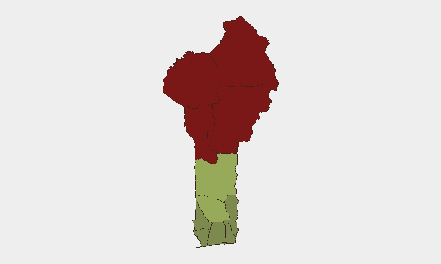
The northern and northwestern departments (Alibori, Atakora, Donga, and Borgou) drive Benin's composite threat profile, with risk scores ranging from 83 to 92. These areas border Nigeria and face direct exposure to Ansaru and affiliated jihadist movements operating across the frontier. Zou, Collines, and Plateau departments represent a secondary risk tier (38–45), while coastal and southern departments (Atlantique, Littoral, Ouémé) remain substantially lower-risk but still subject to organized-crime activity and petty violence. The stark geographic concentration of threat in the north reflects the transnational nature of the insurgent challenge and limited state capacity in remote border zones.
How GeoBit Would Assist
Security teams with personnel or assets in Benin should deploy AOI (Area-of-Interest) Monitoring & Early Warning focused on Alibori, Atakora, and Donga departments to detect emerging jihadist activity, armed clashes, or civil unrest with real-time alerting. OSINT Fusion & Corroboration (combining X/Twitter, Telegram, and multi-language web sources) would separate rumor from confirmed incident and establish precise timestamps and locations. Network & Actor Analysis would map jihadist and organized-crime leadership, funding flows, and recruitment patterns to support long-term risk mitigation and duty-of-care planning.
7-Day Outlook
Benin's security posture is likely to remain stable in the near term, with ongoing counter-terrorism operations in the north and routine organized-crime suppression in urban areas. No indicators suggest imminent escalation, but the underlying transnational threat from Ansaru and criminal networks persists. Risk of sudden localized incidents (ambush, kidnapping, or cross-border infiltration) remains inherent in the northern border zone.
Highest-Risk Areas — Ranked
| # | State / Region | Risk |
|---|---|---|
| 1 | Alibori Department | 92 |
| 2 | Atakora Department | 88 |
| 3 | Donga Department | 85 |
| 4 | Borgou Department | 83 |
| 5 | Zou Department | 45 |
| 6 | Collines Department | 42 |
| 7 | Plateau Department | 38 |
| 8 | Kouffo Department | 35 |
| 9 | Mono Department | 32 |
| 10 | Atlantique Department | 28 |
| 11 | Littoral | 25 |
| 12 | Ouémé Department | 22 |
Sources
Previous Daily Briefs
A new Benin brief is written every day — each with its own risk map and downloadable CSV. Here's the last week; use the calendar to go further back.
📅 Browse every day by calendar →
Highlighted days have a brief. Tap a day for that day's map & analysis, or “csv” for that day's dataset ($5).
Atlas — our AI intelligence desk — emails them this snapshot personally. Nothing else, no list.