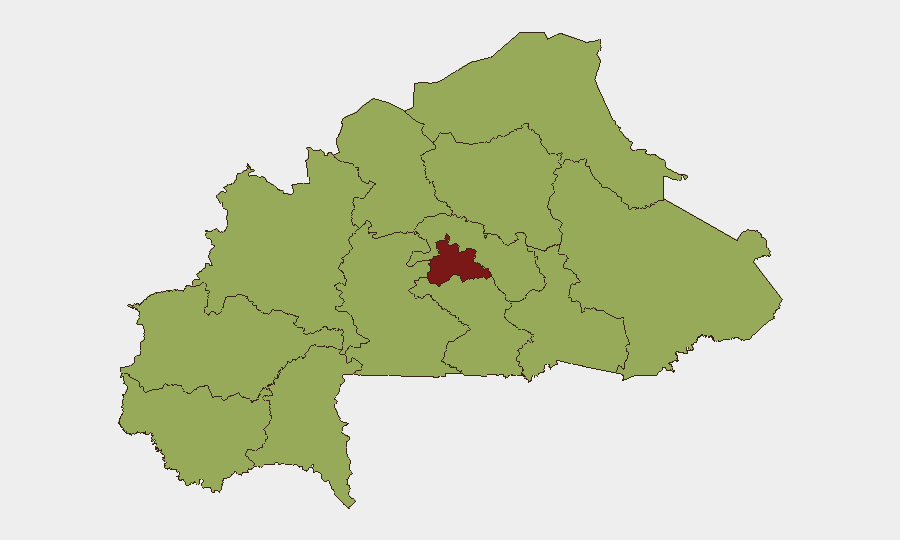
Situation Summary
Burkina Faso remains a high-threat environment (Global Rank #15, composite score 79), driven primarily by sustained insurgent activity across the Sahel and northern regions. No verified kinetic attacks or major civil disturbances have been reported in the last 24–48 hours as of 21 July 2026; however, elevated military posturing and diplomatic tensions—particularly a 19 July conventional forces signal involving Tunisia and a 20 July threat statement from Ghana—indicate regional friction without confirmed engagement. The threat trajectory remains persistently elevated rather than acutely deteriorating in the immediate term.
Key Developments
- National, 20 July 2026 – Ghana issued a threat statement directed at Burkina Faso; operational context and intent remain unclear from available open sources.
- National, 19 July 2026 – Military posture signal recorded between Burkina Faso and Tunisia; no confirmed kinetic engagement or operational details have been independently corroborated.
- National, 19 July 2026 – Public statement issued by Burkinabe authorities; full text and strategic intent require further analysis.
- Koualou border region (Burkina Faso–Benin), 14–16 July 2026 – Joint Burkinabe–Beninese army patrols deployed for counterterrorism and border control reinforcement (background context: outside 24–48h window but reflects ongoing operational posture).
- National, 2–15 July 2026 – Series of counterterrorism operations reported across multiple locations (Diabatou, Yensé, Séguénéga, Pibaoré, Dala, Outendéni) with reported militant casualties and base destructions (background context: pre-dates immediate window but informs sustained operational tempo).
Highest-Risk Areas
Centre region dominates the sub-national risk landscape (score 85), reflecting the concentration of insurgent activity, displaced populations, and security-force operations in and around the capital corridor. The remaining eleven regions cluster at score 55, indicating a broad geographic distribution of threat rather than geographically isolated pockets; Upper-Basins, Boucle du Mouhoun, and the Sahel belt are particularly affected by armed group presence and cross-border activity. Risk is driven by inadequate state capacity in remote areas, logistical constraints on security-force deployment, and the operational reach of militant networks across the north and west.
How GeoBit Would Assist
Security teams with personnel or assets in Burkina Faso should leverage Intel Sweep and multi-language OSINT feeds to monitor unfolding diplomatic and military signals (such as the Ghana and Tunisia developments) in real time. AOI Monitoring & Early Warning with persistent geospatial watch on Centre, Sahel, and border regions would provide advance notice of operational tempo shifts, displacement patterns, or security-force repositioning. Network & Actor Analysis combined with Conflict & Military force-structure tracking enables teams to map militant group movement, assess splinter-group activity, and correlate with reported counterterrorism operations—essential for duty-of-care route planning and facility-risk assessments.
7-Day Outlook
Military posturing between Burkina Faso, Tunisia, and Ghana suggests potential escalation of regional tensions, though kinetic engagement remains unconfirmed. Insurgent activity is likely to persist across northern and western corridors, with security forces maintaining offensive tempo in response. Risk of sudden localized clashes or kidnappings in Centre and Sahel regions remains elevated; movement and gatherings outside secure compounds should be treated as high-risk through at least late July.
Highest-Risk Areas — Ranked
| # | State / Region | Risk |
|---|---|---|
| 1 | Centre | 85 |
| 2 | Upper-Basins | 55 |
| 3 | Boucle du Mouhoun | 55 |
| 4 | Central-West | 55 |
| 5 | Central-South | 55 |
| 6 | Central-East | 55 |
| 7 | Waterfalls | 55 |
| 8 | Southwest | 55 |
| 9 | Sahel | 55 |
| 10 | Central-North | 55 |
| 11 | East | 55 |
| 12 | North | 55 |
Sources
Previous Daily Briefs
A new Burkina Faso brief is written every day — each with its own risk map and downloadable CSV. Here's the last week; use the calendar to go further back.
📅 Browse every day by calendar →
Highlighted days have a brief. Tap a day for that day's map & analysis, or “csv” for that day's dataset ($5).
Atlas — our AI intelligence desk — emails them this snapshot personally. Nothing else, no list.