Situation Summary
Chad remains at moderate global risk (rank #29, composite score 79) with 21 tracked events in the current cycle. The country's security environment is shaped primarily by cross-border dynamics with Sudan rather than internal instability; active Sudanese military operations in Darfur near the Chadian frontier are driving refugee flows, health infrastructure strain, and border security pressures in eastern provinces. No major internal civil unrest, political crisis, or infrastructure attacks have been confirmed in the last 24–48 hours. Regional diplomatic efforts, notably Nigeria–Chad bilateral engagement announced in late June, signal incremental cooperation on basin-level security.
Key Developments
- Kulbus, West Darfur (Sudan–Chad border), reported 1 July 2026: Sudanese Armed Forces claim recapture of the town of Kulbus following "decisive battles" against RSF units. Armed actor presence persists in pockets along the frontier, directly affecting Chadian border security and cross-border armed group mobility in eastern Chad.
- Eastern Chad (refugee-hosting regions, Sudan border), ongoing as of 1 July 2026: Humanitarian reporting confirms large-scale influx of Sudanese refugees correlating with measles and meningitis outbreaks. Health infrastructure in border provinces is under acute strain; travel risk elevated in affected areas due to disease vector concentration.
- Nigeria–Chad bilateral statement, 1 July 2026: Official communication reaffirms strategic commitment to strengthening bilateral relations and regional security cooperation, particularly in the Lake Chad Basin against cross-border crime and insurgent activity. No new operational incidents tied to this statement; primarily diplomatic signaling.
- Event signal: Coast Guard property seizure/damage, 1 July 2026: Recorded in event feed; insufficient open-source detail to confirm location, parties involved, or operational impact.
- Event signal: Multi-actor public statements (Chad government, US, Trinidad and Tobago, student groups), 30 June–2 July 2026: Signals indicate diplomatic messaging and civil expression; no direct security incident or policy shift corroborated by independent sources as of reporting time.
Highest-Risk Areas
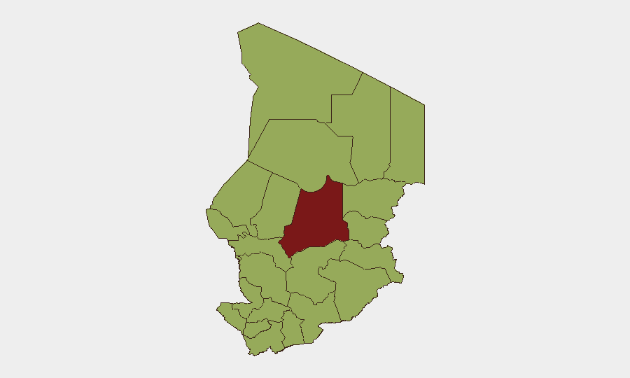
Batha region (composite risk 85) substantially exceeds all other provinces and warrants priority monitoring; it sits in central-north Chad, historically linked to pastoral conflict, resource competition, and irregular armed activity. The second tier—Ennedi-Ouest, Wadi Fira, Ouaddaï, Sila, Salamat, and eastern zones (all risk 55)—reflects the eastern and northern border belt where Sudanese conflict spillover, refugee pressure, and armed-group transit are concentrated. N'Djamena (risk 55), the capital, registers equal risk to eastern provinces, likely driven by event density and dual exposure to political instability signals and cross-border crime networks. The uniform mid-range risk across the eastern and southern tier suggests diffuse rather than localized threat drivers.
How GeoBit Would Assist
AOI Monitoring & Early Warning on Batha, eastern refugee zones, and the Sudan–Chad frontier would provide persistent watch for armed group movement, military buildup, or sudden security shifts before they escalate to reportable incidents. Conflict & Military mapping and force-structure tracking would clarify Sudanese and RSF positions near the border and forecast spillover risk into Chad. Humanitarian & NGO data integration combined with Environmental & Health monitoring would enable duty-of-care teams to track refugee arrivals, disease vectors, and health facility capacity in real time—critical for personnel health protocols.
7-Day Outlook
No imminent major escalation is forecast, but the Sudan–Chad border will remain the primary security variable; further Sudanese military gains in Darfur could accelerate refugee flows and armed-group transit into eastern Chad. Diplomatic engagement between Nigeria and Chad may stabilize the Lake Chad Basin operationally, reducing opportunistic cross-border raiding. Monitor Batha and eastern frontier zones for any uptick in armed-group activity or Sudanese force movements in the coming week.
Highest-Risk Areas — Ranked
| # | State / Region | Risk |
|---|---|---|
| 1 | Batha | 85 |
| 2 | Ennedi-Ouest | 55 |
| 3 | Wadi Fira | 55 |
| 4 | Ouaddaï | 55 |
| 5 | Sila | 55 |
| 6 | Salamat | 55 |
| 7 | East Ennedi | 55 |
| 8 | Kanem | 55 |
| 9 | Lac | 55 |
| 10 | N'Djamena | 55 |
| 11 | Hadjer-Lamis | 55 |
| 12 | Chari-Baguirmi | 55 |
Sources
Previous Daily Briefs
A new Chad brief is written every day — each with its own risk map and downloadable CSV. Here's the last week; use the calendar to go further back.
📅 Browse every day by calendar →
Highlighted days have a brief. Tap a day for that day's map & analysis, or “csv” for that day's dataset ($5).